File:Bathgate (1986) station geograph-3257521-by-Ben-Brooksbank.jpg
Jump to navigation
Jump to search

Size of this preview: 800 × 514 pixels. Other resolutions: 320 × 205 pixels | 640 × 411 pixels | 1,024 × 658 pixels | 1,280 × 822 pixels | 2,255 × 1,448 pixels.
Original file (2,255 × 1,448 pixels, file size: 2.64 MB, MIME type: image/jpeg)
Captions
Captions
Add a one-line explanation of what this file represents
Summary[edit]
_station_geograph-3257521-by-Ben-Brooksbank.jpg&action=edit§ion=1)
| Description |
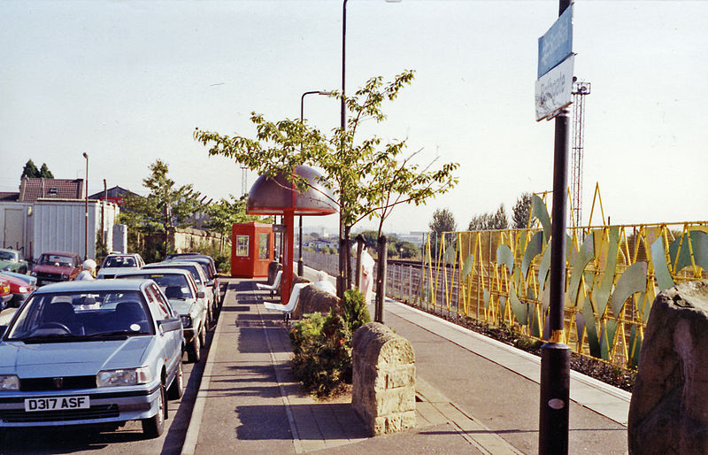
English: Bathgate (1986) station. View SE, towards Edinburgh. This single-platform station was opened on 24/3/86 on the site of the former Bathgate Upper station on the ex-NB Edinburgh - Bathgate - Airdrie - Glasgow line, which closed along with the route between Ratho (Bathgate Junction) and Airdrie from 9/1/56 but was restored (Edinburgh - Bathgate) in March 1986. On 18/10/10 this station was replaced a short distance away when the rest (Bathgate - Drumgelloch - Airdrie) of the former route was restored as a modern electrified railway. |
| Date | Taken on 3 September 1991 |
| Source | From geograph.org.uk |
| Author | Ben Brooksbank |
| Permission (Reusing this file) |
Creative Commons Attribution Share-alike license 2.0 |
| Attribution (required by the license) | Ben Brooksbank / Bathgate (1986) station / |
| Camera location | | View this and other nearby images on: OpenStreetMap |
|---|
_station_geograph-3257521-by-Ben-Brooksbank.jpg¶ms=055.898460_N_-003.643029_E_globe:Earth_type:camera_heading:135.00&language=en)
Licensing[edit]
_station_geograph-3257521-by-Ben-Brooksbank.jpg&action=edit§ion=2)

|
This image was taken from the Geograph project collection. See this photograph's page on the Geograph website for the photographer's contact details. The copyright on this image is owned by Ben Brooksbank and is licensed for reuse under the Creative Commons Attribution-ShareAlike 2.0 license.
|
This file is licensed under the Creative Commons Attribution-Share Alike 2.0 Generic license.
Attribution: Ben Brooksbank
- You are free:
- to share – to copy, distribute and transmit the work
- to remix – to adapt the work
- Under the following conditions:
- attribution – You must give appropriate credit, provide a link to the license, and indicate if changes were made. You may do so in any reasonable manner, but not in any way that suggests the licensor endorses you or your use.
- share alike – If you remix, transform, or build upon the material, you must distribute your contributions under the same or compatible license as the original.
File history
Click on a date/time to view the file as it appeared at that time.
| Date/Time | Thumbnail | Dimensions | User | Comment | |
|---|---|---|---|---|---|
| current | 10:44, 27 December 2012 | | 2,255 × 1,448 (2.64 MB) | Chevin (talk | contribs) | == {{int:filedesc}} == {{Information |Description={{en|1='''Bathgate (1986) station.'''<br/> View SE, towards Edinburgh. This single-platform station was opened on 24/3/86 on the site of the former Bathgate Upper station on the ex-NB Edinburgh - Bathga... |
You cannot overwrite this file.
File usage on Commons
The following page uses this file:
_station_geograph-3257521-by-Ben-Brooksbank.jpg&oldid=818558986)