File:Basin New.png
Jump to navigation
Jump to search
Size of this preview: 493 × 599 pixels. Other resolutions: 197 × 240 pixels | 619 × 752 pixels.
Original file (619 × 752 pixels, file size: 156 KB, MIME type: image/png)
Captions
Captions
Add a one-line explanation of what this file represents
Summary[edit]
| Description |
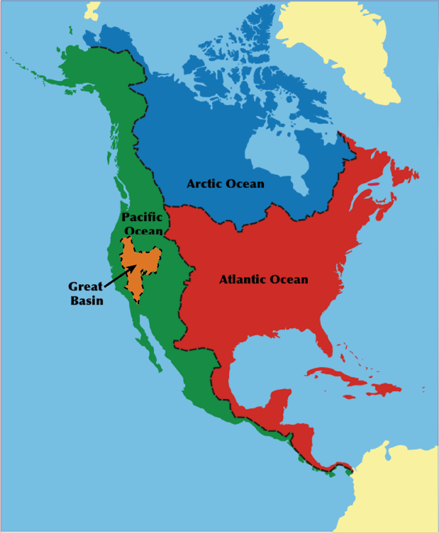
English: Updated North American drainage basins / watersheds map
|
| Date | 21 August 2006 (original upload date) |
| Source | Transferred from en.wikipedia to Commons. |
| Author | MojaveNC at English Wikipedia |
Licensing[edit]
| This work has been released into the public domain by its author, MojaveNC at English Wikipedia. This applies worldwide. In some countries this may not be legally possible; if so: MojaveNC grants anyone the right to use this work for any purpose, without any conditions, unless such conditions are required by law. |
Original upload log[edit]
The original description page was here. All following user names refer to en.wikipedia.
- 2006-08-21 18:03 MojaveNC 619×752×8 (159609 bytes) Updated Great Basin image
File history
Click on a date/time to view the file as it appeared at that time.
| Date/Time | Thumbnail | Dimensions | User | Comment | |
|---|---|---|---|---|---|
| current | 04:00, 26 March 2023 | | 619 × 752 (156 KB) | Hike395 (talk | contribs) | rv original research |
| 15:06, 27 November 2010 |  | 619 × 752 (176 KB) | Hike796 (talk | contribs) | Greenland is part of North America, and northern limit of Atlantic Ocean in Canada is 60th parallel north | |
| 12:56, 2 January 2008 |  | 619 × 752 (156 KB) | Psemper (talk | contribs) | {{Information |Description= |Source= http://upload.wikimedia.org/wikipedia/en/4/49/Basin_New.png |Date= |Author= |Permission= |other_versions= }} |
You cannot overwrite this file.
File usage on Commons
The following 2 pages use this file:
File usage on other wikis
The following other wikis use this file:
- Usage on ar.wikipedia.org
- Usage on bg.wikipedia.org
- Usage on ca.wikipedia.org
- Usage on de.wikipedia.org
- Usage on eo.wikipedia.org
- Usage on es.wikipedia.org
- Usage on hu.wikipedia.org
- Usage on id.wikipedia.org
- Usage on it.wikipedia.org
- Usage on ka.wikipedia.org
- Usage on kk.wikipedia.org
- Usage on ko.wikipedia.org
- Usage on nl.wikipedia.org
- Usage on pt.wikipedia.org
- Usage on sk.wikipedia.org
- Usage on sq.wikipedia.org
- Usage on sr.wikipedia.org
- Usage on sv.wikipedia.org
- Usage on trv.wikipedia.org
- Usage on tr.wikipedia.org
- Usage on uk.wikipedia.org
- Usage on vi.wikipedia.org
- Usage on www.wikidata.org
- Usage on zh.wikipedia.org