File:Basel - Straßenbahn - Netzplan-2.svg
Jump to navigation
Jump to search

Size of this PNG preview of this SVG file: 510 × 599 pixels. Other resolutions: 204 × 240 pixels | 408 × 480 pixels | 654 × 768 pixels | 871 × 1,024 pixels | 1,743 × 2,048 pixels | 714 × 839 pixels.
Original file (SVG file, nominally 714 × 839 pixels, file size: 216 KB)
Captions
Captions
Add a one-line explanation of what this file represents
| Description |
|
||
| Date | |||
| Source | Own work based on: Basel - Straßenbahn - Netzplan.svg by Maximilian Dörrbecker | ||
| Author | Maximilian Dörrbecker, / post-processing by Niabot (changing the placements of the elements of the legend) | ||
| Permission (Reusing this file) |
Maximilian Dörrbecker, / post-processing by Niabot (changing the placements of the elements of the legend, the copyright holder of this work, hereby publishes it under the following license: This file is licensed under the Creative Commons Attribution-Share Alike 2.5 Generic license. Attribution: Maximilian Dörrbecker, / post-processing by Niabot (changing the placements of the elements of the legend
|
||
| Other versions |
|
||
| SVG development | This map was created with Adobe Illustrator, and with Inkscape.
|


File history
Click on a date/time to view the file as it appeared at that time.
| Date/Time | Thumbnail | Dimensions | User | Comment | |
|---|---|---|---|---|---|
| current | 16:13, 14 February 2008 | | 714 × 839 (216 KB) | Niabot (talk | contribs) | Felder vertauscht |
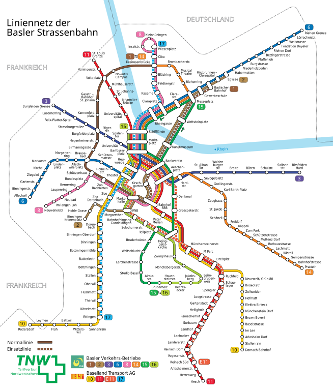
| 13:10, 14 February 2008 |  | 714 × 839 (216 KB) | Niabot (talk | contribs) | {{Information |Description= *{{de|Karte: Schema-Netzplan der Straßenbahn Basel}} *{{en|Map: Basel streetcar network}} *{{fr|Plan: Réseau des tramways de Bâle}} |Source= Self made, based on Image:Basel - Straßenbahn - Netzplan.svg by [[:de:User:Ch |
You cannot overwrite this file.
File usage on Commons
The following 5 pages use this file:
File usage on other wikis
The following other wikis use this file:
- Usage on de.wikipedia.org