File:Balkanzug route.svg
Jump to navigation
Jump to search

Size of this PNG preview of this SVG file: 800 × 600 pixels. Other resolutions: 320 × 240 pixels | 640 × 480 pixels | 1,024 × 768 pixels | 1,280 × 960 pixels | 2,560 × 1,920 pixels | 1,200 × 900 pixels.
Original file (SVG file, nominally 1,200 × 900 pixels, file size: 62 KB)
Captions
Captions
Add a one-line explanation of what this file represents
| Description |
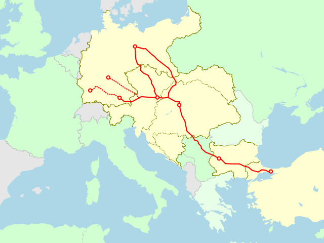
English: Route of Balkanzug(Berlin/Straßburg/München/Würzburg - Konstantinopel(Istanbul)) in 1916-1918. Countries in light yellow are Central Powers and those in light green are Allies. Serbia was occupied by Central Powers in 1916. Borders are based on the IEG-Maps project [1].
日本語: 1916年から1918年にかけてのバルカン列車(ベルリン・シュトラスブルク・ミュンヘン・ヴュルツブルク - コンスタンティノープル(イスタンブール))の走行経路図。薄黄色は中央同盟国、薄緑色は連合国で、国境は1914年(開戦直前)時点のもの。セルビアは1916年には中央同盟国に占領されている。国境に関するデータはIEG-Mapsプロジェクト[2]による。 |
||||||||||
| Date | |||||||||||
| Source | Own work | ||||||||||
| Author | Matsukaze | ||||||||||
| Permission (Reusing this file) |
|

File history
Click on a date/time to view the file as it appeared at that time.
| Date/Time | Thumbnail | Dimensions | User | Comment | |
|---|---|---|---|---|---|
| current | 13:01, 29 June 2011 | | 1,200 × 900 (62 KB) | Matsukaze (talk | contribs) | {{Information |Description={{en|1=Route of Balkanzug(Berlin/Straßburg/München/Würzburg - Konstantinopel(Istanbul)) in 1916-1918. Countries in light yellow are Central Powers and those in light green are Allies. Serbia was occupied by Central Powers in |
You cannot overwrite this file.
File usage on Commons
There are no pages that use this file.
File usage on other wikis
The following other wikis use this file:
- Usage on de.wikipedia.org
- Usage on it.wikipedia.org
- Usage on ja.wikipedia.org
- Usage on pl.wikipedia.org
- Usage on tr.wikipedia.org