File:Balkans in the 9th century.png
Jump to navigation
Jump to search
Size of this preview: 800 × 430 pixels. Other resolutions: 320 × 172 pixels | 640 × 344 pixels | 1,024 × 550 pixels | 1,696 × 911 pixels.
Original file (1,696 × 911 pixels, file size: 1.54 MB, MIME type: image/png)
Captions
Captions
Add a one-line explanation of what this file represents
Summary[edit]
| Description |
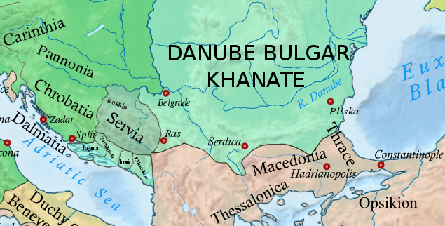
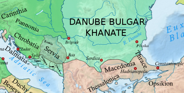
English: Political borders in the Balkans in the 9th century. |
| Date | 2 January 2013, 08:04:13 |
| Source |
This file was derived from: Europe 814.svg: |
| Author | Hel-hama |
Licensing[edit]
This file is licensed under the Creative Commons Attribution-Share Alike 3.0 Unported license.
- You are free:
- to share – to copy, distribute and transmit the work
- to remix – to adapt the work
- Under the following conditions:
- attribution – You must give appropriate credit, provide a link to the license, and indicate if changes were made. You may do so in any reasonable manner, but not in any way that suggests the licensor endorses you or your use.
- share alike – If you remix, transform, or build upon the material, you must distribute your contributions under the same or compatible license as the original.
File history
Click on a date/time to view the file as it appeared at that time.
| Date/Time | Thumbnail | Dimensions | User | Comment | |
|---|---|---|---|---|---|
| current | 20:11, 8 January 2023 | | 1,696 × 911 (1.54 MB) | Miki Filigranski (talk | contribs) | correction according to new version of original file |
| 07:21, 31 July 2022 |  | 635 × 322 (392 KB) | Miki Filigranski (talk | contribs) | Reverted to version as of 14:59, 29 December 2020 (UTC) - stop reverting my map | |
| 05:13, 18 July 2022 |  | 635 × 322 (427 KB) | Ionelen (talk | contribs) | Reverted to version as of 19:41, 13 April 2022 (UTC) | |
| 07:43, 12 July 2022 |  | 635 × 322 (392 KB) | Ahmet Q. (talk | contribs) | Reverted to version as of 20:16, 19 March 2022 (UTC) | |
| 19:41, 13 April 2022 |  | 635 × 322 (427 KB) | Wojsław12 (talk | contribs) | Reverted to version as of 14:05, 26 February 2022 (UTC) | |
| 20:16, 19 March 2022 |  | 635 × 322 (392 KB) | Silverije (talk | contribs) | Reverted to version as of 23:19, 23 February 2022 (UTC) | |
| 14:05, 26 February 2022 |  | 635 × 322 (427 KB) | TómasdeAquino2 (talk | contribs) | npov | |
| 23:19, 23 February 2022 |  | 635 × 322 (392 KB) | Silverije (talk | contribs) | map more correct | |
| 21:27, 26 January 2022 |  | 635 × 322 (427 KB) | TómasdeAquino2 (talk | contribs) | update | |
| 14:59, 29 December 2020 |  | 635 × 322 (392 KB) | Miki Filigranski (talk | contribs) | Uploaded a work by Hel-hama from https://commons.wikimedia.org/wiki/File:Europe_814.svg with UploadWizard |
You cannot overwrite this file.
File usage on Commons
There are no pages that use this file.
File usage on other wikis
The following other wikis use this file:
- Usage on el.wikipedia.org
- Usage on en.wikipedia.org
- Usage on es.wikipedia.org
- Usage on fr.wikipedia.org
- Usage on it.wikipedia.org
- Usage on uk.wikipedia.org
Metadata
Categories:
- Maps of the history of Croatia in the Middle Ages
- Maps of the history of Serbia in the Early Middle Ages
- Maps of medieval Bosnian and neighboring states
- Maps of 9th-century Bulgaria
- Maps of the history of the medieval Balkans
- Maps of the history of Bosnia and Herzegovina in the Early Middle Ages
- Maps of the Principality of Pannonian Croatia