File:Bahnstrecke Rybník–Lipno nad Vltavou 2.png
Jump to navigation
Jump to search
Size of this preview: 800 × 387 pixels. Other resolutions: 320 × 155 pixels | 640 × 310 pixels | 1,024 × 495 pixels | 1,280 × 619 pixels | 2,560 × 1,238 pixels | 4,857 × 2,349 pixels.
Original file (4,857 × 2,349 pixels, file size: 12.27 MB, MIME type: image/png)
Captions
Captions
Add a one-line explanation of what this file represents
Summary[edit]
| Description |
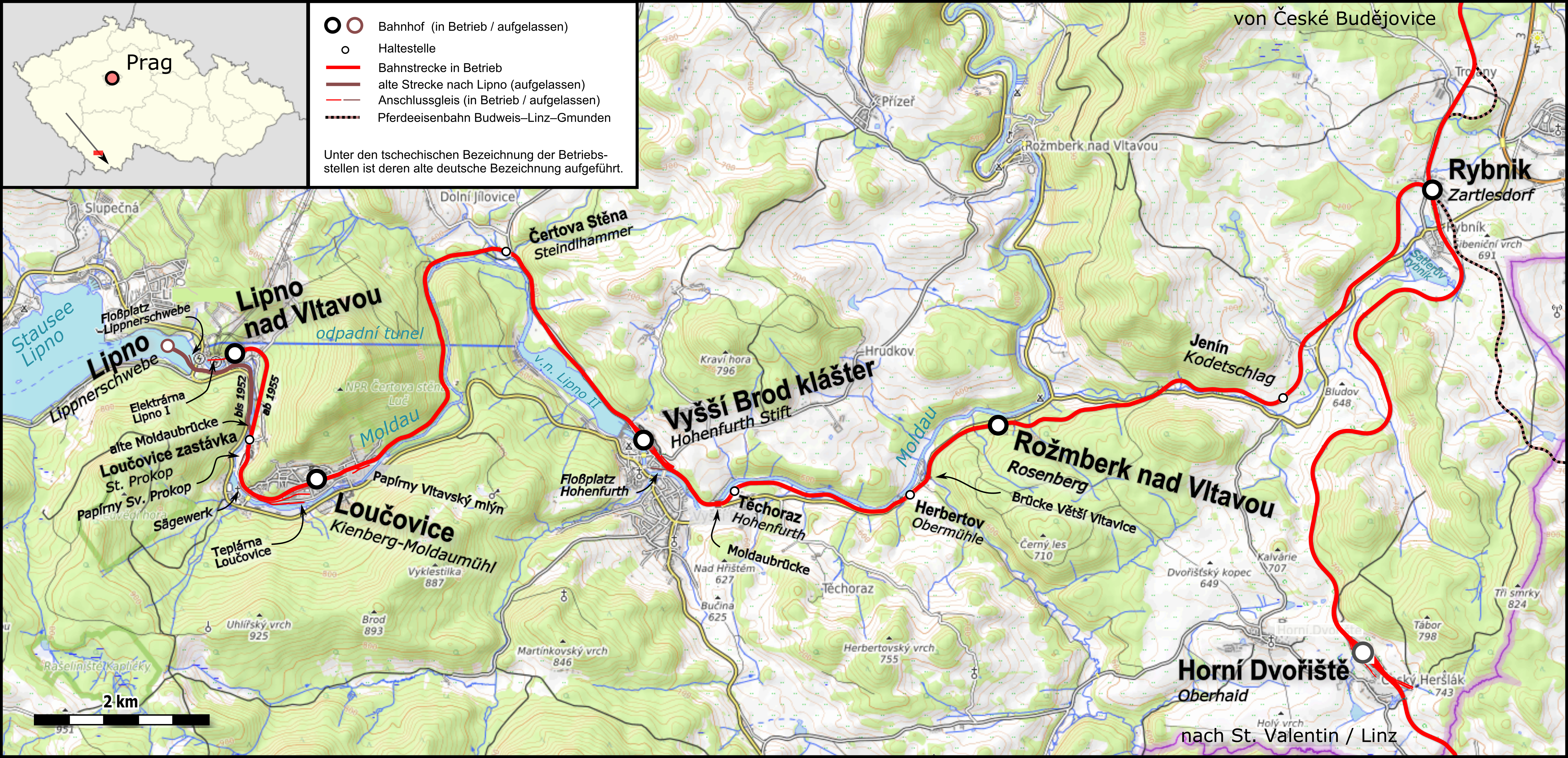
English: Map of the Rybník – Lipno nad Vltavou railway Čeština: Mapa Železniční trať Rybník - Lipno nad Vltavou
Deutsch: Karte der Bahnstrecke Rybník–Lipno nad Vltavou |
|||||||||
| Date | ||||||||||
| Source |
Map was created using:
|
|||||||||
| Creator |
|
|||||||||
| Permission (Reusing this file) |
|
|||||||||
| Geotemporal data | ||||||||||
| Bounding box |
|
|||||||||
| Georeferencing | ||||||||||
| Other versions |
Railway map Rybník–Lipno nad Vltavou.png:  |
|||||||||
Licensing[edit]
I, the copyright holder of this work, hereby publish it under the following license:
This file is licensed under the Creative Commons Attribution-Share Alike 3.0 Unported license.
- You are free:
- to share – to copy, distribute and transmit the work
- to remix – to adapt the work
- Under the following conditions:
- attribution – You must give appropriate credit, provide a link to the license, and indicate if changes were made. You may do so in any reasonable manner, but not in any way that suggests the licensor endorses you or your use.
- share alike – If you remix, transform, or build upon the material, you must distribute your contributions under the same or compatible license as the original.
| This work is licensed under the Open Database License (summary). |
File history
Click on a date/time to view the file as it appeared at that time.
| Date/Time | Thumbnail | Dimensions | User | Comment | |
|---|---|---|---|---|---|
| current | 20:18, 22 October 2017 | | 4,857 × 2,349 (12.27 MB) | Pechristener (talk | contribs) | Flossplatz Lipno am alten Platz wieder hergestellt. |
| 19:19, 22 October 2017 |  | 3,399 × 1,644 (7.15 MB) | Pechristener (talk | contribs) | gemäss Disk (Ch ivk) repariert. | |
| 16:51, 22 October 2017 |  | 3,399 × 1,644 (7.14 MB) | Pechristener (talk | contribs) | Flossplatz westlich des Bhfs eingezeichnet. | |
| 20:03, 21 October 2017 |  | 3,399 × 1,644 (7.13 MB) | Pechristener (talk | contribs) | Grösse (hoffentlich) verbessert, kleine Korrekturen an der Formatierung der Beschriftung | |
| 19:35, 21 October 2017 |  | 3,298 × 1,595 (6.81 MB) | Pechristener (talk | contribs) | korr gemäss Disk | |
| 13:26, 21 October 2017 |  | 3,298 × 1,595 (6.79 MB) | Pechristener (talk | contribs) | Verbesserungen gemäss Disk | |
| 08:47, 21 October 2017 |  | 2,591 × 1,253 (4.4 MB) | Pechristener (talk | contribs) | == {{int:filedesc}} == {{Map |Description={{en|1=Map of the Rybník – Lipno nad Vltavou railway}}{{cz|1=Mapa Železniční trať Rybník - Lipno nad Vltavou}} {{de|1=Karte der [[:de:Bahnstrecke... |
You cannot overwrite this file.
File usage on Commons
The following 4 pages use this file:
File usage on other wikis
The following other wikis use this file:
- Usage on de.wikipedia.org