File:Bahnstrecke Nürnberg-Crailsheim.png
Jump to navigation
Jump to search

Size of this preview: 800 × 441 pixels. Other resolutions: 320 × 176 pixels | 640 × 353 pixels | 1,024 × 564 pixels | 1,280 × 705 pixels | 2,000 × 1,102 pixels.
Original file (2,000 × 1,102 pixels, file size: 1.75 MB, MIME type: image/png)
Captions
Captions
Add a one-line explanation of what this file represents
| Description |
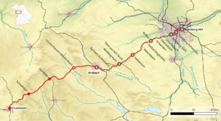
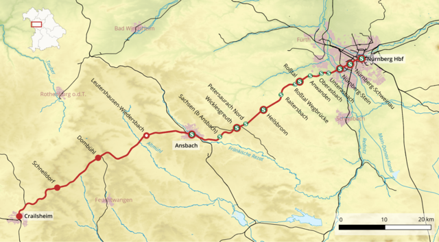
Deutsch: Karte der Bahnstrecke Nürnberg–Crailsheim, Stand Dezember 2016
English: Map of the Nuremberg–Crailsheim railway as of December 2016 |
|||
| Date | ||||
| Source |
Own work, using
|
|||
| Author | Földhegy | |||
| Permission (Reusing this file) |
This file is licensed under the Creative Commons Attribution-Share Alike 3.0 Unported license.
|
File history
Click on a date/time to view the file as it appeared at that time.
| Date/Time | Thumbnail | Dimensions | User | Comment | |
|---|---|---|---|---|---|
| current | 16:27, 2 January 2017 | | 2,000 × 1,102 (1.75 MB) | Földhegy (talk | contribs) | {{Information |Description={{de|Karte der {{w|Bahnstrecke Nürnberg–Crailsheim|3=de}}, Stand Dezember 2016}} {{en|Map of the {{w|Nuremberg–Crailsheim railway|3=en}} as of December 2016}} |Source={{own}}, using * OpenStreetMap data * [https://dd... |
You cannot overwrite this file.
File usage on Commons
The following 5 pages use this file:
File usage on other wikis
The following other wikis use this file:
- Usage on de.wikipedia.org
- Usage on en.wikipedia.org
- Usage on hu.wikipedia.org
- Usage on ja.wikipedia.org
- Usage on www.wikidata.org