File:Bahamas regions map-es.svg
Jump to navigation
Jump to search

Size of this PNG preview of this SVG file: 800 × 577 pixels. Other resolutions: 320 × 231 pixels | 640 × 461 pixels | 1,024 × 738 pixels | 1,280 × 923 pixels | 2,560 × 1,846 pixels | 1,559 × 1,124 pixels.
Original file (SVG file, nominally 1,559 × 1,124 pixels, file size: 857 KB)
Captions
Captions
Add a one-line explanation of what this file represents
Summary[edit]
| Description |
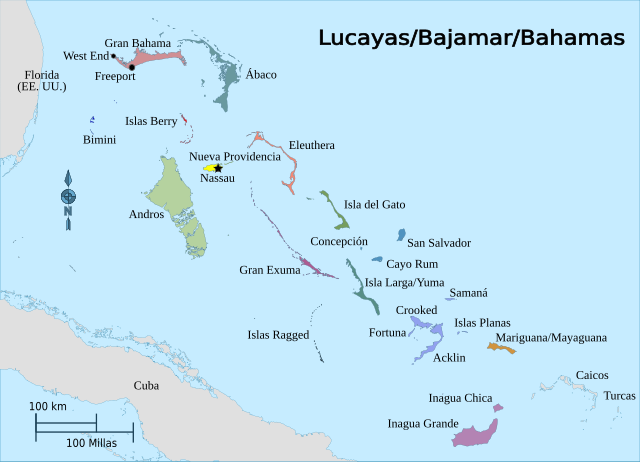
Español: Islas Lucayas, de la Bajamar o Bahamas. |
| Date | |
| Source | |
| Author | Peter Fitzgerald, NordNordWest |

Licensing[edit]
This file is licensed under the Creative Commons Attribution-Share Alike 3.0 Unported license.
- You are free:
- to share – to copy, distribute and transmit the work
- to remix – to adapt the work
- Under the following conditions:
- attribution – You must give appropriate credit, provide a link to the license, and indicate if changes were made. You may do so in any reasonable manner, but not in any way that suggests the licensor endorses you or your use.
- share alike – If you remix, transform, or build upon the material, you must distribute your contributions under the same or compatible license as the original.
File history
Click on a date/time to view the file as it appeared at that time.
| Date/Time | Thumbnail | Dimensions | User | Comment | |
|---|---|---|---|---|---|
| current | 19:52, 7 February 2022 | | 1,559 × 1,124 (857 KB) | Rowanwindwhistler (talk | contribs) | Uploaded a work by Peter Fitzgerald, NordNordWest from https://commons.wikimedia.org/wiki/File:Bahamas_regions_map.svg with UploadWizard |
You cannot overwrite this file.
File usage on Commons
The following 2 pages use this file:
File usage on other wikis
The following other wikis use this file:
- Usage on es.wikipedia.org
- Usage on fr.wikipedia.org