File:BC regions 2010.png
Jump to navigation
Jump to search

Size of this preview: 740 × 600 pixels. Other resolutions: 296 × 240 pixels | 593 × 480 pixels | 948 × 768 pixels | 1,264 × 1,024 pixels | 2,419 × 1,960 pixels.
Original file (2,419 × 1,960 pixels, file size: 1.41 MB, MIME type: image/png)
Captions
Captions
Add a one-line explanation of what this file represents
Summary[edit]
| Description |
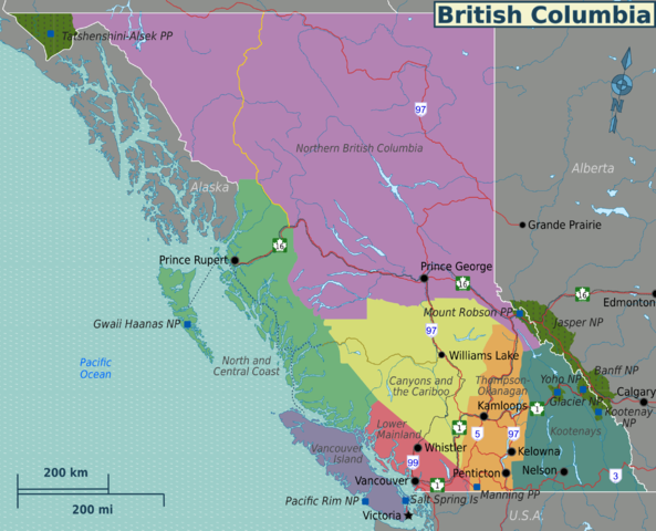
English: English Wikivoyage-style regions map of British Columbia. It shows travel regions, major cities and roads in the province. |
| Date | |
| Source | File:BC regions map.svg - SVG base map for all language versions |
| Author | Drawn by Shaund |
| Other versions | File:BC regions map (fr).png - French version of the map |
.png)
Licensing[edit]
This file is licensed under the Creative Commons Attribution-Share Alike 4.0 International, 3.0 Unported, 2.5 Generic, 2.0 Generic and 1.0 Generic license.
- You are free:
- to share – to copy, distribute and transmit the work
- to remix – to adapt the work
- Under the following conditions:
- attribution – You must give appropriate credit, provide a link to the license, and indicate if changes were made. You may do so in any reasonable manner, but not in any way that suggests the licensor endorses you or your use.
- share alike – If you remix, transform, or build upon the material, you must distribute your contributions under the same or compatible license as the original.
Original upload log[edit]
| This file was imported from Wikivoyage WTS. |
The original description page was here. All following user names refer to wts.wikivoyage-old.
- 2010-01-02 21:33 (WT-shared) Shaund archive copy at the Wayback Machine 1200×1125 (411361 bytes) {{Imagecredit|credit=Drawn by [[User:Shaund|Shaund]]|captureDate=Jan 2, 2010|location=British Columbia|source=|caption=|description=regions (Import from wikitravel.org/shared)
- 2010-01-05 06:22 (WT-shared) Shaund archive copy at the Wayback Machine 2419×1960 (1323433 bytes) add rail, parks (Import from wikitravel.org/shared)
- 2010-01-05 14:36 (WT-shared) Shaund archive copy at the Wayback Machine 2419×1960 (1333888 bytes) add highway shields hidden in last image (Import from wikitravel.org/shared)
- 2012-03-24 05:44 (WT-shared) Joelf[dead link] 2419×1960 (1481958 bytes) fixed minor misspellings (Import from wikitravel.org/shared)
File history
Click on a date/time to view the file as it appeared at that time.
| Date/Time | Thumbnail | Dimensions | User | Comment | |
|---|---|---|---|---|---|
| current | 05:38, 21 November 2012 | | 2,419 × 1,960 (1.41 MB) | OgreBot (talk | contribs) | (BOT): Reverting to most recent version before archival |
| 05:38, 21 November 2012 |  | 2,419 × 1,960 (1.27 MB) | OgreBot (talk | contribs) | (BOT): Uploading old version of file from wts.wikivoyage; originally uploaded on 2010-01-05 14:36:41 by (WT-shared) Shaund | |
| 05:38, 21 November 2012 |  | 2,419 × 1,960 (1.26 MB) | OgreBot (talk | contribs) | (BOT): Uploading old version of file from wts.wikivoyage; originally uploaded on 2010-01-05 06:22:23 by (WT-shared) Shaund | |
| 05:37, 21 November 2012 |  | 1,200 × 1,125 (402 KB) | OgreBot (talk | contribs) | (BOT): Uploading old version of file from wts.wikivoyage; originally uploaded on 2010-01-02 21:33:53 by (WT-shared) Shaund | |
| 22:41, 17 November 2012 |  | 2,419 × 1,960 (1.41 MB) | MGA73bot2 (talk | contribs) | {{BotMoveToCommons|wts.oldwikivoyage|year={{subst:CURRENTYEAR}}|month={{subst:CURRENTMONTHNAME}}|day={{subst:CURRENTDAY}}}} == {{int:filedesc}} == {{Information |description=. regions map of British Columbia, British Columbia * Map of: British Columbia... |
You cannot overwrite this file.
File usage on Commons
The following 2 pages use this file:
File usage on other wikis
The following other wikis use this file:
- Usage on en.wikivoyage.org
- Usage on es.wikivoyage.org
- Usage on he.wikivoyage.org
- Usage on it.wikivoyage.org
- Usage on pt.wikivoyage.org
- Usage on ru.wikivoyage.org