File:Aztec Airport VFR Map (2022).jpg
Jump to navigation
Jump to search

Size of this preview: 600 × 600 pixels. Other resolutions: 240 × 240 pixels | 480 × 480 pixels | 768 × 768 pixels | 1,250 × 1,250 pixels.
Original file (1,250 × 1,250 pixels, file size: 1.99 MB, MIME type: image/jpeg)
Captions
Captions
Add a one-line explanation of what this file represents
Summary[edit]
.jpg&action=edit§ion=1)
| Description |
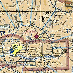
English: FAA VFR chart depicting location of Aztec Airport, San Juan County, New Mexico, USA. |
| Date | |
| Source | https://www.faa.gov/air_traffic/flight_info/aeronav/digital_products/vfr/ |
| Author | Federal Aviation Administration, VFR Raster Charts. Retrieved 2022-01-27. |
| Camera location | | View this and other nearby images on: OpenStreetMap |
|---|
.jpg¶ms=036.836531_N_-108.028590_E_globe:Earth_type:camera__&language=en)
Licensing[edit]
.jpg&action=edit§ion=2)
This image or file is a work of a Federal Aviation Administration employee, taken or made as part of that person's official duties. As a work of the U.S. federal government, the image is in the public domain in the United States.
|
 |
File history
Click on a date/time to view the file as it appeared at that time.
| Date/Time | Thumbnail | Dimensions | User | Comment | |
|---|---|---|---|---|---|
| current | 23:05, 19 January 2022 | | 1,250 × 1,250 (1.99 MB) | Ziesmerd (talk | contribs) | Uploaded a work by Federal Aviation Administration, VFR Raster Charts. Retrieved 2022-01-27. from https://www.faa.gov/air_traffic/flight_info/aeronav/digital_products/vfr/ with UploadWizard |
You cannot overwrite this file.
File usage on Commons
There are no pages that use this file.
File usage on other wikis
The following other wikis use this file:
- Usage on en.wikipedia.org
.jpg&oldid=832581509)