File:AutoZone Park satellite view.png
Jump to navigation
Jump to search

Size of this preview: 800 × 527 pixels. Other resolutions: 320 × 211 pixels | 640 × 421 pixels | 992 × 653 pixels.
Original file (992 × 653 pixels, file size: 1.22 MB, MIME type: image/png)
Captions
Captions
Add a one-line explanation of what this file represents
| Description |
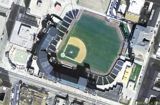
Français : Image satellite du stade AutoZone Park de Memphis, TN
Image USGS Urban Area de Nasa World Wind |
| Source | NASA World Wind 1.3.5 |
| Author | NASA |
Licensing[edit]
| This image is in the public domain because it is a screenshot from NASA’s globe software World Wind using a public domain layer, such as Blue Marble, MODIS, Landsat, SRTM, USGS or GLOBE.
|
 |
Original upload log[edit]
The original description page was here. All following user names refer to fr.wikipedia.
- 2007-11-05 15:15 Betp 992×653×??? (1276116 bytes) Image satellite du stade AutoZone Park de Memphis, TN ==Source== Image USGS Urban Area de Nasa World Wind ==Licence== {{Domaine public NASA}}
File history
Click on a date/time to view the file as it appeared at that time.
| Date/Time | Thumbnail | Dimensions | User | Comment | |
|---|---|---|---|---|---|
| current | 10:24, 20 September 2008 | | 992 × 653 (1.22 MB) | File Upload Bot (Magnus Manske) (talk | contribs) | {{BotMoveToCommons|fr.wikipedia}} {{Information |Description={{fr|Image satellite du stade AutoZone Park de Memphis, TN ==Source== Image USGS Urban Area de Nasa World Wind}} |Source=Transferred from [http://fr.wikipedia.org fr.wikipedia]; transferred to |
You cannot overwrite this file.
File usage on Commons
There are no pages that use this file.
File usage on other wikis
The following other wikis use this file:
- Usage on de.wikipedia.org
- Usage on fr.wikipedia.org