File:Austria extreme points.png
Jump to navigation
Jump to search
Size of this preview: 800 × 439 pixels. Other resolutions: 320 × 176 pixels | 820 × 450 pixels.
Original file (820 × 450 pixels, file size: 47 KB, MIME type: image/png)
Captions
Captions
Add a one-line explanation of what this file represents

|
This map has been uploaded by Electionworld from en.wikipedia.org to enable the |
Summary[edit]
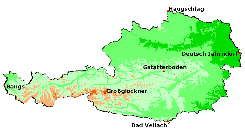
The extreme points of Austria.
Licensing[edit]
Stemonitis, the copyright holder of this work, hereby publishes it under the following license:

|
Permission is granted to copy, distribute and/or modify this document under the terms of the GNU Free Documentation License, Version 1.2 or any later version published by the Free Software Foundation; with no Invariant Sections, no Front-Cover Texts, and no Back-Cover Texts. A copy of the license is included in the section entitled GNU Free Documentation License. |
| This file is licensed under the Creative Commons Attribution-Share Alike 3.0 Unported license. | ||
| Attribution: Stemonitis | ||
| ||
| This licensing tag was added to this file as part of the GFDL licensing update. |
File history
Click on a date/time to view the file as it appeared at that time.
| Date/Time | Thumbnail | Dimensions | User | Comment | |
|---|---|---|---|---|---|
| current | 22:50, 23 December 2006 | | 820 × 450 (47 KB) | Electionworld (talk | contribs) | {{ew|en|Stemonitis}} == Summary == The extreme points of Austria. == Licensing == {{GFDL-user|Stemonitis}} |
You cannot overwrite this file.
File usage on Commons
The following 2 pages use this file:
File usage on other wikis
The following other wikis use this file:
- Usage on bs.wikipedia.org
- Usage on de.wikipedia.org
- GEONAM Österreich
- Geographie Österreichs
- Vorarlberger Geographisches Informationssystem
- Österreichische Karte
- Geoland.at
- Digitales Oberösterreichisches Raum-Informations-System
- ViennaGIS
- GIS-Steiermark
- Kärntner Geografisches Informationssystem
- Karten & Geoinformation in Niederösterreich
- Hora.gv.at
- Tiroler Rauminformationssystem
- Vorlage:Navigationsleiste GIS in Österreich
- Salzburger Geographisches Informationssystem
- Altlastenatlas
- GIS-Burgenland
- Usage on en.wikipedia.org
- Usage on he.wikipedia.org
- Usage on hu.wikipedia.org
- Usage on ka.wikipedia.org
- Usage on nn.wikipedia.org
- Usage on no.wikipedia.org
- Usage on pt.wikipedia.org