File:Austria-Hungary map ES.svg
Jump to navigation
Jump to search

Size of this PNG preview of this SVG file: 776 × 600 pixels. Other resolutions: 311 × 240 pixels | 621 × 480 pixels | 994 × 768 pixels | 1,280 × 989 pixels | 2,560 × 1,978 pixels | 783 × 605 pixels.
Original file (SVG file, nominally 783 × 605 pixels, file size: 379 KB)
Captions
Captions
Add a one-line explanation of what this file represents
| Description |
English:
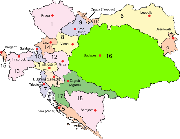
Austria–Hungary: Empire of Austria (Cisleithania): 1. Bohemia, 2. Bukovina, 3. Carinthia, 4. Carniola, 5. Dalmatia, 6. Galicia, 7. Küstenland, 8. Lower Austria, 9. Moravia, 10. Salzburg, 11. Silesia, 12. Styria, 13. Tyrol, 14. Upper Austria, 15. Vorarlberg; Kingdom of Hungary (Transleithania): 16. Hungary proper 17. Croatia-Slavonia; Austrian-Hungarian Co-dominion: 18. Bosnia and Herzegovina Deutsch:
Österreich-Ungarn 1910: Cisleithanien: 1. Böhmen, 2. Bukowina, 3. Kärnten, 4. Krain, 5. Dalmatien, 6. Galizien, 7. Küstenland, 8. Österreich unter der Enns, 9. Mähren, 10. Salzburg, 11. Schlesien, 12. Steiermark, 13. Tirol, 14. Österreich ob der Enns, 15. Vorarlberg; Transleithanien: 16. Ungarn, 17. Kroatien und Slawonien; 18. Bosnien und Herzegowina Español: Austria–Hungría: Imperio Austriaco (Cisleitania): 1. Bohemia, 2. Bucovina, 3. Carintia, 4. Carniola, 5. Dalmacia, 6. Galicia, 7. Provincia costera 8. Baja Austria, 9. Moravia, 10. Salzburgo, 11. Silesia, 12. Estiria, 13. Tirol, 14. Alta Austria, 15. Vorarlberg; Reino de Hungría (Transleitania): 16. Hungría 17. Croacia-Eslavonia; Condomio austro-magiar: 18. Bosnia y Hercegovina |
| Date | (UTC) |
| Source | |
| Author |
|
| Other versions | Derivative works of this file: CisleitaniaTransleitaniaYBosniaHercegovina.svg |
| This is a retouched picture, which means that it has been digitally altered from its original version. Modifications: Spanish version in svg.. The original can be viewed here: Austria-Hungary map new.svg:
|
I, the copyright holder of this work, hereby publish it under the following license:
| |
This work has been released into the public domain by its author, Example, at the [[::|English Wikipedia]] project. This applies worldwide. In case this is not legally possible: |
Original upload log[edit]
This image is a derivative work of the following images:
- File:Austria-Hungary_map_new.svg licensed with PD-user-w
- 2009-02-20T12:28:19Z Ivh123 783x605 (250731 Bytes) {{Information |Description={{en| '''Austria–Hungary''':'''Empire of Austria (Cisleithania)''': 1. Bohemia, 2. Bukovina, 3. Carinthia, 4. Carniola, 5. Dalmatia, 6. Galicia, 7. Küstenland, 8. Lower Austria, 9. Moravia, 10. S
Uploaded with derivativeFX
File history
Click on a date/time to view the file as it appeared at that time.
| Date/Time | Thumbnail | Dimensions | User | Comment | |
|---|---|---|---|---|---|
| current | 09:40, 29 July 2017 | | 783 × 605 (379 KB) | Rowanwindwhistler (talk | contribs) | Fake text added |
| 21:34, 3 September 2016 |  | 783 × 605 (342 KB) | Rowanwindwhistler (talk | contribs) | Leópolis, some text moved | |
| 17:35, 11 February 2010 |  | 783 × 605 (338 KB) | Rowanwindwhistler (talk | contribs) | {{Information |Description={{en| <br>'''<u>Austria–Hungary</u>''':<br>'''Empire of Austria (Cisleithania)''': 1. Bohemia, 2. Bukovina, 3. Carinthia, 4. Carniola, 5. Dalmatia, 6. Galicia, 7. Küstenland, 8. Lower Austria, 9. Moravia, 10. Salzburg, 11. Si |
You cannot overwrite this file.
File usage on Commons
The following 4 pages use this file:
.svg)
File usage on other wikis
The following other wikis use this file:
- Usage on ast.wikipedia.org
- Usage on es.wikipedia.org
- Usage on eu.wikipedia.org
- Usage on gl.wikipedia.org
- Usage on pt.wikipedia.org