File:Austria-Hungary map-pl.svg
Jump to navigation
Jump to search

Size of this PNG preview of this SVG file: 776 × 600 pixels. Other resolutions: 311 × 240 pixels | 621 × 480 pixels | 994 × 768 pixels | 1,280 × 989 pixels | 2,560 × 1,978 pixels | 783 × 605 pixels.
Original file (SVG file, nominally 783 × 605 pixels, file size: 331 KB)
Captions
Captions
Add a one-line explanation of what this file represents
| Description |
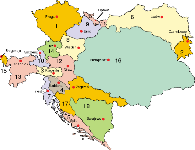
Polski: Austro–Węgry:
Cesarstwo Austrii (Przedlitawia): 1. Czechy, 2. Bukowina, 3. Karyntia, 4. Kraina, 5. Dalmacja, 6. Galicja i Lodomeria, 7. Pobrzeże, 8. Austria przed Anizą, 9. Morawy, 10. Salzburg, 11. Śląsk Austriacki, 12. Styria, 13. Tyrol, 14. Austria za Anizą, 15. Vorarlberg; Królestwo Węgier (Zalitawia): 16. Węgry, 17. Chorwacja; Bośnia: 18. Bośnia i Hercegowina
Deutsch: Österreich-Ungarn 1910:
Cisleithanien: 1. Böhmen, 2. Bukowina, 3. Kärnten, 4. Krain, 5. Dalmatien, 6. Galizien, 7. Küstenland, 8. Österreich unter der Enns, 9. Mähren, 10. Salzburg, 11. Schlesien, 12. Steiermark, 13. Tirol, 14. Österreich ob der Enns, 15. Vorarlberg; Transleithanien: 16. Ungarn, 17. Kroatien und Slawonien; 18. Bosnien und Herzegowina
English: Austria–Hungary:
Empire of Austria (Cisleithania): 1. Bohemia, 2. Bukovina, 3. Carinthia, 4. Carniola, 5. Dalmatia, 6. Galicia, 7. Küstenland, 8. Lower Austria, 9. Moravia, 10. Salzburg, 11. Silesia, 12. Styria, 13. Tyrol, 14. Upper Austria, 15. Vorarlberg; Kingdom of Hungary (Transleithania): 16. Hungary proper 17. Croatia-Slavonia; Austrian-Hungarian Condominium: 18. Bosnia and Herzegovina
Magyar: Ausztria–Magyarország
Osztrák Császárság (Ciszlajtánia): 1. Csehország, 2. Bukovina, 3. Karintia, 4. Krajna, 5. Dalmácia, 6. Galícia, 7. Tengermellék, 8. Alsó-Ausztria, 9. Morvaország, 10. Salzburg, 11. Szilézia, 12. Stájerország, 13. Tirol, 14. Felső-Ausztria, 15. Vorarlberg; Magyar Királyság (Transzlajtánia): 16. Magyarország 17. Horvát-Szlavónország; osztrák–magyar kondomínium: 18. Bosznia és Hercegovina
Latina: Austria-Hungaria: Imperium Austriae (Cisleithania): 1. Bohemia, 2. Bucovina, 3. Carinthia, 4. Carniola, 5. Dalmatia, 6. Galicia, 7. Litorale, 8. Austria Inferior, 9. Moravia, 10. Salisburgum, 11. Silesia, 12. Styria, 13. Tirolis, 14. Austria Superior, 15. Cisarulana; Regnum Hungariae (Transleithania): 16. Hungaria, 17. Croatia et Slavonia Condominium : 18. Bosnia et Herzegovina |
| Date | |
| Source | |
| Author |
|
| This is a retouched picture, which means that it has been digitally altered from its original version. Modifications: translated. The original can be viewed here: Austria-Hungary map.svg:
|
I, the copyright holder of this work, hereby publish it under the following license:
| |
This work has been released into the public domain by its author, Example, at the [[::|English Wikipedia]] project. This applies worldwide. In case this is not legally possible: |
Original upload log[edit]
This image is a derivative work of the following images:
- File:Austria-Hungary_map.svg licensed with PD-user-w
- 2010-04-16T22:48:31Z Vearthy 783x605 (339320 Bytes) changed colours
- 2009-09-14T22:49:21Z Kirk 783x605 (338680 Bytes) english names of capitals
- 2009-09-14T22:41:55Z Kirk 783x605 (338634 Bytes) correctioons
- 2009-08-09T21:00:32Z Gugganij 783x605 (322419 Bytes) Reverted to version as of 19:00, 24 July 2009, reason: the province "Küstenland" was blackened
- 2009-07-25T22:13:52Z Cäsium137 800x640 (280574 Bytes) Valid IDs
- 2009-07-24T23:41:46Z Cäsium137 800x640 (280239 Bytes) smooth
- 2009-07-24T19:00:43Z Hk kng 783x605 (322419 Bytes) a bit of cleanup
- 2009-07-24T18:32:00Z Hk kng 783x605 (326688 Bytes) testing whether using another font helps
- 2009-07-24T09:46:45Z NordNordWest 783x605 (326543 Bytes) Reverted to version as of 05:20, 30 March 2007
- 2009-07-24T09:36:23Z Zsoni 776x600 (2107 Bytes) Korrektur.
- 2007-03-30T05:20:57Z W!B: 783x605 (326543 Bytes) syntax cleanup: groups, named ids, sorted, ..
- 2006-06-28T23:01:58Z Neoneo13 783x605 (243229 Bytes) Taken from english Wikipedia. Created by user IMeowbot {{PD-self}}
Uploaded with derivativeFX
File history
Click on a date/time to view the file as it appeared at that time.
| Date/Time | Thumbnail | Dimensions | User | Comment | |
|---|---|---|---|---|---|
| current | 23:27, 16 April 2010 | | 783 × 605 (331 KB) | Vearthy (talk | contribs) | {{Information |Description={{en| <br/>'''<u>Austria–Hungary</u>''':<br/>'''Empire of Austria (Cisleithania)''': 1. Bohemia, 2. Bukovina, 3. Carinthia, 4. Carniola, 5. Dalmatia, 6. Galicia, 7. Küstenland, 8. Lower Austria, 9. Moravia, 10. Salzburg, 11. |
You cannot overwrite this file.
File usage on Commons
The following 3 pages use this file:
File usage on other wikis
The following other wikis use this file:
- Usage on pl.wikipedia.org
- Galicja (Europa Środkowa)
- Śląsk Opawski
- Śląsk Cieszyński
- Styria
- Kraj koronny
- Królestwo Dalmacji
- Trójjedyne Królestwo Chorwacji, Slawonii i Dalmacji
- Królestwo Czech
- Wikipedysta:Malarz pl/szablony/Państwo infobox
- Wikipedysta:Malarz pl/szablony/Państwo infobox/16
- Wikipedysta:Malarz pl/szablony/Państwo infobox/18
- Usage on pl.wiktionary.org
- Usage on uk.wikipedia.org