File:AucklandRailMap.png
Jump to navigation
Jump to search

Size of this preview: 667 × 600 pixels. Other resolutions: 267 × 240 pixels | 534 × 480 pixels | 854 × 768 pixels | 1,139 × 1,024 pixels | 1,388 × 1,248 pixels.
Original file (1,388 × 1,248 pixels, file size: 226 KB, MIME type: image/png)
Captions
Captions
Add a one-line explanation of what this file represents
Summary[edit]
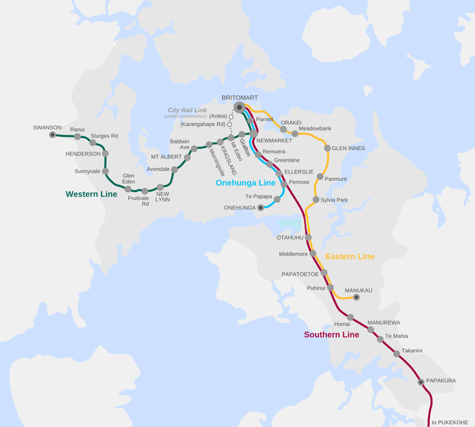
| Description | Map of the Auckland railway network | |||
| Date | ||||
| Source | Own work | |||
| Author | Vardion (the uploader) | |||
| Other versions |
|


Licensing[edit]
I, the copyright holder of this work, hereby publish it under the following licenses:

|
Permission is granted to copy, distribute and/or modify this document under the terms of the GNU Free Documentation License, Version 1.2 or any later version published by the Free Software Foundation; with no Invariant Sections, no Front-Cover Texts, and no Back-Cover Texts. A copy of the license is included in the section entitled GNU Free Documentation License. |
This file is licensed under the Creative Commons Attribution-Share Alike 4.0 International, 3.0 Unported, 2.5 Generic, 2.0 Generic and 1.0 Generic license.
- You are free:
- to share – to copy, distribute and transmit the work
- to remix – to adapt the work
- Under the following conditions:
- attribution – You must give appropriate credit, provide a link to the license, and indicate if changes were made. You may do so in any reasonable manner, but not in any way that suggests the licensor endorses you or your use.
- share alike – If you remix, transform, or build upon the material, you must distribute your contributions under the same or compatible license as the original.
You may select the license of your choice.
File history
Click on a date/time to view the file as it appeared at that time.
| Date/Time | Thumbnail | Dimensions | User | Comment | |
|---|---|---|---|---|---|
| current | 07:27, 23 October 2019 | | 1,388 × 1,248 (226 KB) | VerySunday (talk | contribs) | Replaced Boston Rd with Grafton |
| 22:06, 16 March 2017 |  | 1,388 × 1,248 (232 KB) | Akld guy (talk | contribs) | Removed Westfield Railway Station; deleted dots at fare stage stations | |
| 19:36, 17 January 2016 |  | 1,388 × 1,248 (251 KB) | Vardion (talk | contribs) | moving two station names, as per request | |
| 05:07, 17 January 2016 |  | 1,388 × 1,248 (226 KB) | Vardion (talk | contribs) | distinguishing fare stations; shrinking Parnell dot | |
| 01:22, 17 January 2016 |  | 1,388 × 1,247 (221 KB) | Vardion (talk | contribs) | attempt to update (having had to recreate image due to not having original file immediately available) | |
| 06:08, 10 August 2008 |  | 1,392 × 1,249 (247 KB) | Vardion (talk | contribs) | ||
| 08:00, 16 March 2008 |  | 1,392 × 1,249 (254 KB) | Vardion (talk | contribs) | {{Information |Description=Map of the Auckland railway network (revised according to suggestions) |Source=self-made |Date=16 March 2008 |Author= Vardion |Permission= |other_versions= }} | |
| 00:54, 15 March 2008 |  | 1,718 × 2,060 (336 KB) | Vardion (talk | contribs) | {{Information |Description=Map of the Auckland railway network |Source=Self-made |Date=15 March 2008 |Author=Vardion (the uploader) |Permission= |other_versions= }} |
You cannot overwrite this file.
File usage on Commons
The following 12 pages use this file:
- User:Chumwa/OgreBot/Potential transport maps/2016 January 11-20
- User:Chumwa/OgreBot/Potential transport maps/2017 March 11-20
- User:Chumwa/OgreBot/Potential transport maps/2019 October 21-31
- User:Chumwa/OgreBot/Public transport information/2016 January 11-20
- User:Chumwa/OgreBot/Public transport information/2017 March 11-20
- User:Chumwa/OgreBot/Public transport information/2019 October 21-31
- User:Chumwa/OgreBot/Transport Maps/2016 January 11-20
- User:Chumwa/OgreBot/Transport Maps/2017 March 11-20
- User:Chumwa/OgreBot/Transport Maps/2019 October 21-31
- User:Chumwa/OgreBot/Travel and communication maps/2016 January 11-20
- User:Chumwa/OgreBot/Travel and communication maps/2017 March 11-20
- User:Chumwa/OgreBot/Travel and communication maps/2019 October 21-31
File usage on other wikis
The following other wikis use this file:
- Usage on en.wikipedia.org
- Usage on es.wikipedia.org
- Usage on fr.wikipedia.org
- Usage on pt.wikipedia.org
- Usage on www.wikidata.org
- Usage on zh.wikipedia.org