File:Atlas of the World WDL2686.jpg
Jump to navigation
Jump to search

Size of this preview: 660 × 599 pixels. Other resolutions: 264 × 240 pixels | 529 × 480 pixels | 846 × 768 pixels | 1,128 × 1,024 pixels.
Original file (1,128 × 1,024 pixels, file size: 300 KB, MIME type: image/jpeg)
Captions
Captions
Add a one-line explanation of what this file represents
Summary[edit]
| Русский: Атлас мира
Français : Atlas du monde English: Atlas of the World 中文:天下地图 Português: Atlas do Mundo العربية: أطلس العالم Español: Atlas del mundo |
|
|---|---|
| Title |
Русский: Атлас мира
Français : Atlas du monde
English: Atlas of the World
中文:天下地图
Português: Atlas do Mundo
العربية: أطلس العالم
Español: Atlas del mundo |
| Description |
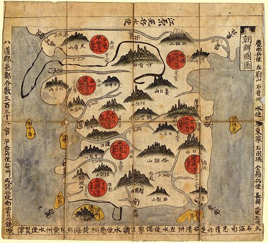
Русский: "Ch’ŏnha chido" (Атлас мира) представляет собой копию XIX века традиционного корейского атласа, выпущенного в начале правления династии Чосон (1392-1910 гг.). Одна из карт атласа "Ch’ŏnhado" (Карта мира) является уникальной и популярной картой, которая составлена так, что Китай располагается в центре карты мира с точки зрения Кореи. Типичным содержанием традиционных корейских атласов этого периода является следующее: карта мира под названием "Ch’ŏnhado", карта Кореи, карты восьми провинций Кореи и карты соседних стран: Китая, Японии и островов Рюкю. Различные ученые считают, что вымышленные названия мест на карте "Ch’ŏnhado" взяты из Shanghaijing. Shanghaijing (Описание гор и морей) является сборником описаний древнего мира Китая, написанным в период правления династии Цинь в III веке до н.э. На карте Китая в данном атласе четко изображены Великая китайская стена, а также реки Хуанхэ и Янцзы. Возможно, что данная карта была составлена на основе карты, созданной в период китайской империи Мин (1368-1644 гг.).
Карты мира Français : Le Ch’ŏnha chido (Atlas du monde) est une copie du XIXe siècle de l'atlas coréen traditionnel produit au début de la dynastie de Chosŏn (1392-1910). L'une des cartes de l'atlas, "Ch'ŏnhado" (carte du monde), est une carte mondiale centrée sur la Chine, unique et populaire, vue d'une perspective coréenne. Le contenu typique des atlas de tradition coréenne au cours de cette période sont les suivants : une carte du monde qui porte le titre Ch'ŏnhado, une carte de la Corée, des cartes de huit provinces de Corée, et des cartes des pays voisins - la Chine, le Japon, et les îles Ryukyu. Divers chercheurs ont attribué les noms de lieux imaginaires dans Ch'ŏnhado à Shanghaijing. Shanghaijing (Classique des montagnes et des mers) est une compilation de descriptions de la Chine antique, écrites au cours de la dynastie Chin au 3ème siècle avant J.-C. La carte de la Chine dans cet atlas met en évidence la Grande Muraille ainsi que les fleuves Jaune et Yangtsé. Cette carte est peut-être dérivée d'une carte produite au cours de la dynastie Ming (1368-1644).
Cartes du monde English: The Ch’ŏnha chido (Atlas of the world) is a 19th century copy of the traditional Korean atlas produced in the early Chosŏn dynasty (1392-1910). One of the maps in the atlas, "Ch’ŏnhado" (Map of the world), is a unique and popular China-centered world map seen in Korean perspective. The typical contents of the traditional Korean atlases during this period consist of the following: a world map bearing the title Ch’ŏnhado, a map of Korea, maps of the eight provinces of Korea, and maps of neighboring countries--China, Japan, and the Ryukyu Islands. Various scholars have attributed the imaginary place names in Ch’ŏnhado to Shanghaijing. Shanghaijing (Classic of mountains and seas) is a compilation of the descriptions of the ancient world of China, written during the Chin dynasty in the 3rd century B.C. The map of China in this atlas prominently depicts the Great Wall and the Yellow and Yangtze rivers. This map may have been derived from a map produced during the Chinese Ming Empire (1368-1644).
World maps 中文:这本 《Ch’ŏnha chido》(世界地图集)是早期朝鲜王朝(1392 - 1910 年)制作的传统朝鲜地图集的十九世纪副本。地图集中的“Ch’ŏnhado”(世界地图)从朝鲜视角出发,而以中国为中心,是一幅独特而风行的世界地图。传统朝鲜地图集当时的典型内容包括:一幅标题为Ch’ŏnhado的世界地图,一幅朝鲜地图,朝鲜八个省份地图以及邻国地图——中国、日本以及琉球群岛。 大多数学者均认为 Ch’ŏnhado 的虚构地名出自 《山海经》. 《山海经》 (有关山与海的古典文学)是一部描述中国古代世界的汇编,约创作于公元前 三世纪的秦朝。 本地图集中的中国地图突出描述了长城、黄河和长江。 本地图可能源自中国明朝(1368 - 1644 年)的一幅地图。
世界地图 Português: O Ch’ŏnha chido (Atlas do mundo) é uma cópia do século XIX do tradicional atlas coreano produzido no início da dinastia Choson (1392-1910). Um dos mapas no atlas, "Ch'ŏnhado" (Mapa do mundo), é um mapa do mundo original e popular com a China no centro e visto sob a perspectiva coreana. Os conteúdos típicos dos atlas Coreanos durante este período consistiam do seguinte: um mapa do mundo com o título Ch’ŏnhado, um mapa da Coréia, mapas das oito províncias de Coréia, e mapas dos países vizinhos - China, Japão, e as Ilhas Ryukyu. Vários estudiosos atribuiram nomes do lugar imaginário em Ch'ŏnhado para Shanghaijing. Shanghaijing (Clássicos de montanhas e mares) é uma compilação das descrições do mundo antigo da China, escrito durante a dinastia Chin no século IIIterceiro B.C. O mapa da China neste altas descreve prominentemente a Grande Muralha e os rios Amarelo e Yangtze. Este mapa é derivado de um mapa produzido durante o Império Chinês Ming (1368-1644).
Mapas-múndi العربية: إن أطلس تشونها تشيدو (أي أطلس العالم)، هو نسخة تعود إلى القرن التاسع عشر من الأطلس الكوري التقليدي الذي أُنتج في سلالة تشوسون الأولى (1392-1910). إحدى خرائط الأطلس، تشونهادو (خريطة العالم)، فريدة من نوعها وشعبية وتركز على الصين كمحور للعالم ضمن منظور كوري. وتتكون محتويات الأطالس النمطية التقليدية الكورية خلال هذه الفترة من العناصر التالية: خريطة للعالم تحمل اسم تشونهادو وخريطة لكوريا وخرائط لمقاطعات كوريا الثمانية وخرائط الدول المجاورة لكوريا-- الصين واليابان وجزر ريوكيو. وقد عزا علماء مختلفون أسماء الأماكن الخيالية في تشونهادو إلى تشانهيجنغ. تشانهيجنغ (كلاسيكية الجبال والبحار)، وهي مجموعة من أوصاف العالم القديم فى الصين التي كُتبت خلال عهد سلالة تشين في القرن الثالث قبل الميلاد. وتظهر خريطة الصين فى هذا الأطلس بشكل بارز سور الصين العظيم والنهرين الأصفر ويانغتسي. وربما كانت هذه الخريطة مستمدة من خريطة أُنتجت خلال عهد إمبراطورية مينغ في الصين (1368-1644).
خرائط العالم Español: El Ch’ŏnha chido (Atlas del mundo) es una copia que data del siglo XIX del atlas tradicional coreano elaborado a comienzos de la dinastía Chosŏn (1392-1910). Uno de los mapas del atlas, «Ch’ŏnhado» (Mapa del mundo), es un excepcional y popular mapa del mundo, en cuyo centro se encuentra China, visto desde una perspectiva coreana. Los contenidos típicos de los atlas tradicionales coreanos durante este período incluyen: un mapa del mundo con el título de Ch’ŏnhado, un mapa de Corea, mapas de las ocho provincias de Corea, y mapas de los países vecinos: China, Japón y las islas Ryukyu. Varios estudiosos han atribuido los nombres geográficos imaginarios que aparecen en el Ch’ŏnhado al Shanghaijing. Shanghaijing (Clásico de montañas y mares) es una recopilación de las descripciones del mundo antiguo de China, escrita durante la dinastía Chin en el siglo III a. C. El mapa de China de este atlas muestra de manera prominente la Gran Muralla y los ríos Amarillo y Yangtsé. Este mapa podría haber estado basado en un mapa elaborado durante el Imperio chino Ming (1368-1644).
Mapas del mundo |
| Date | between 1800 and 1899 |
| Medium |
Русский: Карты
Français : Cartes
English: Maps
中文:地图
Português: Mapas
العربية: خرائط
Español: Mapas |
| Dimensions |
English: 1 manuscript atlas ([13] folded leaves) : color maps mounted on rice paper ; sheets 30 x 33 centimeters, folded to 15 x 8 centimeters |
| Collection |
Русский: Библиотека Конгресса
Français : Bibliothèque du Congrès
English: Library of Congress
中文:国会图书馆
Português: Biblioteca do Congresso
العربية: مكتبة الكونغرس
Español: Biblioteca del Congreso |
| Place of creation |
Русский: Китай
Français : Chine
English: China
中文:中国
Português: China
العربية: الصين
Español: China |
| Notes | Original language title: 天下地圖 |
| References | http://hdl.loc.gov/loc.wdl/dlc.2686 |
| Source/Photographer |
http://www.wdl.org/media/2686/service/thumbnail/6000x6000/1/1.jpg
|
Licensing[edit]
|
This is a faithful photographic reproduction of a two-dimensional, public domain work of art. The work of art itself is in the public domain for the following reason:
The official position taken by the Wikimedia Foundation is that "faithful reproductions of two-dimensional public domain works of art are public domain".
This photographic reproduction is therefore also considered to be in the public domain in the United States. In other jurisdictions, re-use of this content may be restricted; see Reuse of PD-Art photographs for details. | ||||
File history
Click on a date/time to view the file as it appeared at that time.
| Date/Time | Thumbnail | Dimensions | User | Comment | |
|---|---|---|---|---|---|
| current | 12:06, 11 March 2014 | | 1,128 × 1,024 (300 KB) | Fæ (talk | contribs) | =={{int:filedesc}}== {{Artwork |artist = |author = |title ={{ru|1=Атлас мира}} {{fr|1=Atlas du monde}} {{en|1=Atlas of the World}} {{zh|1=天下地图}} {{pt|1=Atlas do Mundo}} {{ar|1=أطلس العالم}} {{es|1=Atlas del mundo}} |descript... |
You cannot overwrite this file.
File usage on Commons
The following page uses this file: