File:Atlas Vidal-Lablache - carte ethnographique Autriche-Hongrie.jpg
Jump to navigation
Jump to search
Size of this preview: 800 × 575 pixels. Other resolutions: 320 × 230 pixels | 640 × 460 pixels | 1,024 × 735 pixels | 1,280 × 919 pixels | 1,611 × 1,157 pixels.
Original file (1,611 × 1,157 pixels, file size: 535 KB, MIME type: image/jpeg)
Captions
Captions
Add a one-line explanation of what this file represents
Summary[edit]
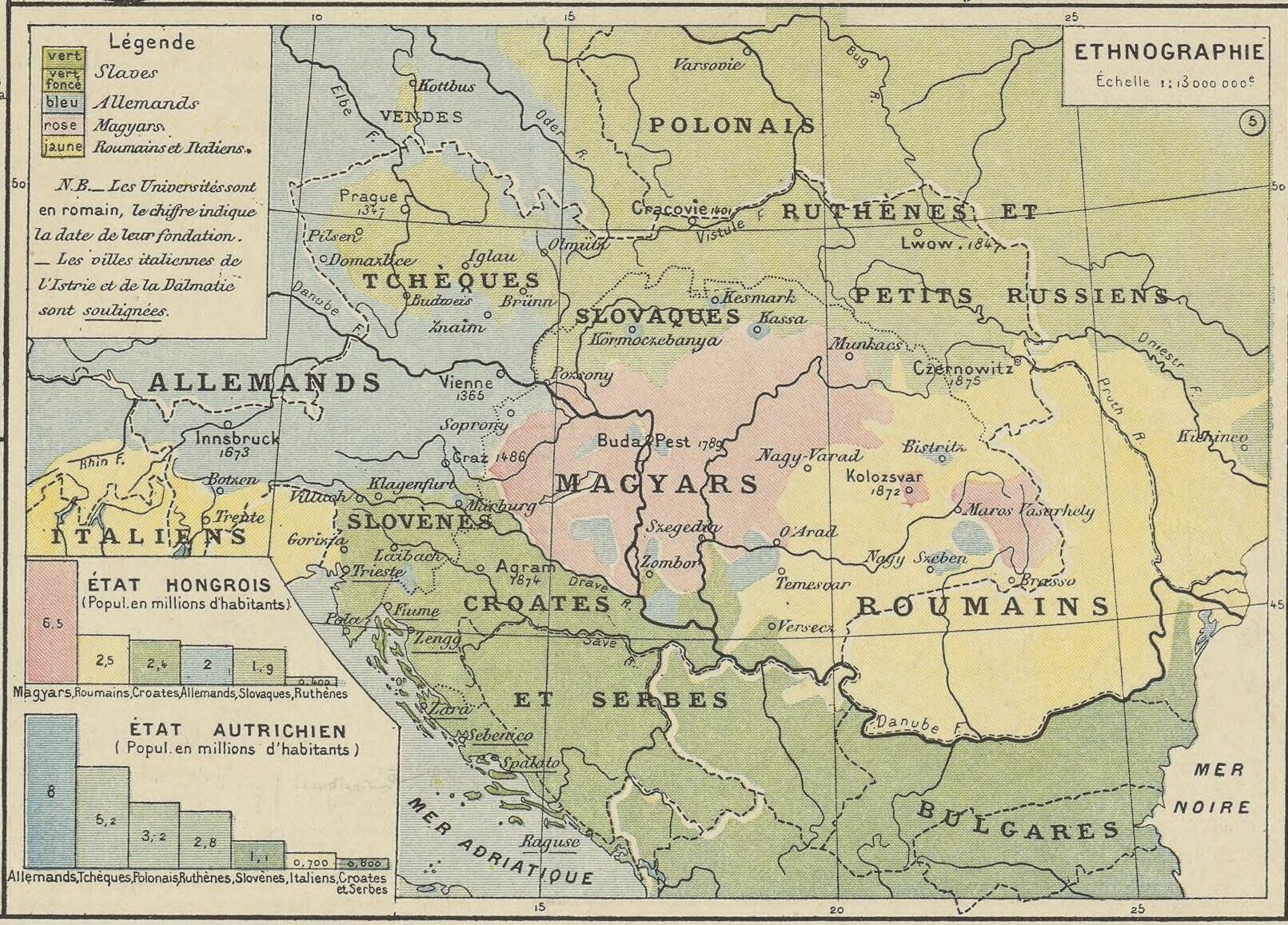
| Autriche-Hongrie ; Italie ancienne ; Alsace-Lorraine : Atlas Vidal-Lablache
( |
|||||||||||||||||||||||||||
|---|---|---|---|---|---|---|---|---|---|---|---|---|---|---|---|---|---|---|---|---|---|---|---|---|---|---|---|
| Author |
Vidal de La Blache, Paul (1845-1918). Cartographe |
||||||||||||||||||||||||||
| Title |
Autriche-Hongrie ; Italie ancienne ; Alsace-Lorraine : Atlas Vidal-Lablache |
||||||||||||||||||||||||||
| Description |
Français : Sujet : Agriculture
Industrie Religions Autriche-Hongrie -- Divisions politiques et administratives Autriche-Hongrie Autriche-Hongrie -- Ethnographie Vienne -- Environs Portes de Fer, Défilé des Italie antique -- Nord -- Antiquité Alsace-Lorraine Échelle(s) : [Échelles diverses] Appartient à l’ensemble documentaire : Alsace1 Couverture : Autriche Hongrie Italie France – Grand-Est Langue : français Éditeur : A. Colin (Paris) |
||||||||||||||||||||||||||
| Date | 1891 | ||||||||||||||||||||||||||
| Dimensions | height: 53 cm (20.8 in); width: 38 cm (14.9 in) | ||||||||||||||||||||||||||
| Collection |
|
||||||||||||||||||||||||||
| References |
Français : Notice du catalogue : http://catalogue.bnf.fr/ark:/12148/cb40700616q |
||||||||||||||||||||||||||
| Source/Photographer |
Français : Bibliothèque nationale de France, département Cartes et plans, GE D-9346
Bibliothèque nationale de France (1/2) |
||||||||||||||||||||||||||
| Permission (Reusing this file) |
|
||||||||||||||||||||||||||
| Other versions | |||||||||||||||||||||||||||

.jpg)
File history
Click on a date/time to view the file as it appeared at that time.
| Date/Time | Thumbnail | Dimensions | User | Comment | |
|---|---|---|---|---|---|
| current | 11:21, 17 August 2023 | | 1,611 × 1,157 (535 KB) | Enyavar (talk | contribs) | File:Autriche-Hongrie ; Italie ancienne ; Alsace-Lorraine - Atlas Vidal-Lablache - btv1b530197220 (1 of 2).jpg cropped 75 % horizontally, 75 % vertically using CropTool with precise mode. |
You cannot overwrite this file.
File usage on Commons
The following 3 pages use this file:
- File:Atlas Vidal-Lablache - carte ethnographique Autriche-Hongrie.jpg
- File:Autriche-Hongrie ; Italie ancienne ; Alsace-Lorraine - Atlas Vidal-Lablache - btv1b530197220 (1 of 2).jpg
- File:Autriche-Hongrie ; Italie ancienne ; Alsace-Lorraine - Atlas Vidal-Lablache - btv1b530197220 (1 of 2) (cropped).jpg (file redirect)
_(cropped).jpg&redirect=no)