File:Athens tram 2007.png
Jump to navigation
Jump to search

Size of this preview: 478 × 599 pixels. Other resolutions: 191 × 240 pixels | 383 × 480 pixels | 900 × 1,128 pixels.
Original file (900 × 1,128 pixels, file size: 212 KB, MIME type: image/png)
Captions
Captions
Add a one-line explanation of what this file represents
Summary[edit]
| Description |
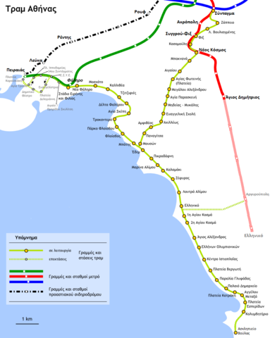
Ελληνικά: Γεωγραφικά ακριβές διάγραμμα - χάρτης του δικτύου τραμ της Αθήνας English: Geographically accurate diagram - map of the Athens tram network |
| Date | (UTC) |
| Source | |
| Author |
|
| This is a retouched picture, which means that it has been digitally altered from its original version. Modifications: Removed copyrighted logo. The original can be viewed here: Athens tram 2007 el.png:
|
Licensing[edit]
This file is licensed under the Creative Commons Attribution-Share Alike 2.5 Generic, 2.0 Generic and 1.0 Generic license.
- You are free:
- to share – to copy, distribute and transmit the work
- to remix – to adapt the work
- Under the following conditions:
- attribution – You must give appropriate credit, provide a link to the license, and indicate if changes were made. You may do so in any reasonable manner, but not in any way that suggests the licensor endorses you or your use.
- share alike – If you remix, transform, or build upon the material, you must distribute your contributions under the same or compatible license as the original.

|
Permission is granted to copy, distribute and/or modify this document under the terms of the GNU Free Documentation License, Version 1.2 or any later version published by the Free Software Foundation; with no Invariant Sections, no Front-Cover Texts, and no Back-Cover Texts. A copy of the license is included in the section entitled GNU Free Documentation License. |
| This file is licensed under the Creative Commons Attribution-Share Alike 3.0 Unported license. | ||
| ||
| This licensing tag was added to this file as part of the GFDL licensing update. |
Original upload log[edit]
This image is a derivative work of the following images:
- File:Athens_tram_2007_el.png licensed with Cc-by-sa-2.5,2.0,1.0, GFDL
- 2007-07-07T19:07:11Z Anastasios 900x1128 (193095 Bytes) {{Information | Description = {{el|Γεωγραφικά ακριβές διάγραμμα - χάρτης του [[:el:Τραμ Αθήνας|δικτύου τραμ της Αθήνας]]}} {{en|Geographically accurate diagram
Uploaded with derivativeFX
File history
Click on a date/time to view the file as it appeared at that time.
| Date/Time | Thumbnail | Dimensions | User | Comment | |
|---|---|---|---|---|---|
| current | 03:34, 8 June 2011 | | 900 × 1,128 (212 KB) | Skgxt2 (talk | contribs) | extension Elliniko-Argyroupoli, Askilipieio Voulas |
| 15:33, 17 May 2009 |  | 900 × 1,128 (167 KB) | Sv1xv (talk | contribs) | {{Information |Description={{el|Γεωγραφικά ακριβές διάγραμμα - χάρτης του δικτύου τραμ της Αθήνας}} {{en|Geographically accurate diagram - map of the [[:en:Athens Tram|At |
You cannot overwrite this file.
File usage on Commons
There are no pages that use this file.
File usage on other wikis
The following other wikis use this file:
- Usage on eo.wikipedia.org
- Usage on fr.wikipedia.org
- Usage on pl.wikipedia.org
- Usage on uk.wikipedia.org
- Usage on zh.wikipedia.org