File:Athens metro future map.png
Jump to navigation
Jump to search

Size of this preview: 610 × 600 pixels. Other resolutions: 244 × 240 pixels | 488 × 480 pixels | 781 × 768 pixels | 1,277 × 1,256 pixels.
Original file (1,277 × 1,256 pixels, file size: 153 KB, MIME type: image/png)
Captions
Captions
Add a one-line explanation of what this file represents
Summary[edit]
| Description |
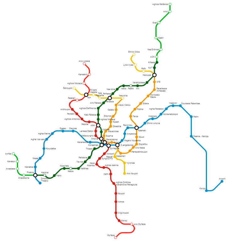
English: Athens metro system. Lines 1, 2, 3, 4 complete. |
| Date | |
| Source | Own work |
| Author | RoseAphro |
Licensing[edit]
I, the copyright holder of this work, hereby publish it under the following license:
This file is licensed under the Creative Commons Attribution-Share Alike 3.0 Unported license.
- You are free:
- to share – to copy, distribute and transmit the work
- to remix – to adapt the work
- Under the following conditions:
- attribution – You must give appropriate credit, provide a link to the license, and indicate if changes were made. You may do so in any reasonable manner, but not in any way that suggests the licensor endorses you or your use.
- share alike – If you remix, transform, or build upon the material, you must distribute your contributions under the same or compatible license as the original.
File history
Click on a date/time to view the file as it appeared at that time.
| Date/Time | Thumbnail | Dimensions | User | Comment | |
|---|---|---|---|---|---|
| current | 16:09, 11 October 2022 | | 1,277 × 1,256 (153 KB) | Antondimak (talk | contribs) | Update. |
| 20:17, 28 July 2020 |  | 1,277 × 1,256 (126 KB) | Maphobbyist (talk | contribs) | Update: The section from Aghia Marina to Nikaia on Line 3 opened | |
| 08:48, 11 March 2019 |  | 1,277 × 1,256 (127 KB) | Χρηστος Μυτακιδης (talk | contribs) | Anotheer update | |
| 13:58, 19 June 2017 |  | 1,277 × 1,256 (140 KB) | Maphobbyist (talk | contribs) | Update | |
| 13:18, 8 September 2012 |  | 1,277 × 1,246 (124 KB) | RoseAphro (talk | contribs) | Zefyri --> Ano Liossia | |
| 13:07, 8 September 2012 |  | 1,254 × 1,279 (124 KB) | RoseAphro (talk | contribs) | cropped | |
| 12:57, 8 September 2012 |  | 1,584 × 1,369 (136 KB) | RoseAphro (talk | contribs) | User created page with UploadWizard |
You cannot overwrite this file.
File usage on Commons
The following 12 pages use this file:
- User:Chumwa/OgreBot/Potential transport maps/2017 June 11-20
- User:Chumwa/OgreBot/Potential transport maps/2019 March 11-20
- User:Chumwa/OgreBot/Public transport information/2017 June 11-20
- User:Chumwa/OgreBot/Public transport information/2019 March 11-20
- User:Chumwa/OgreBot/Public transport information/2020 July 21-31
- User:Chumwa/OgreBot/Public transport information/2022 October 11-20
- User:Chumwa/OgreBot/Transport Maps/2017 June 11-20
- User:Chumwa/OgreBot/Transport Maps/2019 March 11-20
- User:Chumwa/OgreBot/Transport Maps/2020 July 21-31
- User:Chumwa/OgreBot/Transport Maps/2022 October 11-20
- User:Chumwa/OgreBot/Travel and communication maps/2017 June 11-20
- User:Chumwa/OgreBot/Travel and communication maps/2019 March 11-20
File usage on other wikis
The following other wikis use this file:
- Usage on el.wikipedia.org
- Usage on fr.wikipedia.org
- Usage on zh.wikipedia.org