File:Aspeberget - KMB - 16000300014849.jpg

Original file (2,980 × 1,973 pixels, file size: 8.25 MB, MIME type: image/jpeg)
Captions
Captions
| Aspeberget
( |
|||||||||||||||||||||||||||
|---|---|---|---|---|---|---|---|---|---|---|---|---|---|---|---|---|---|---|---|---|---|---|---|---|---|---|---|
| Photographer |
|
||||||||||||||||||||||||||
| Title |
Aspeberget |
||||||||||||||||||||||||||
| Original caption |
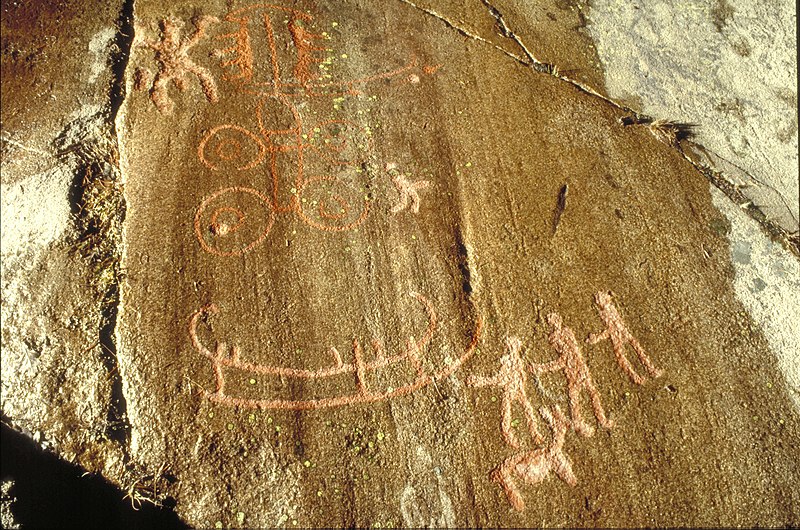
Notera Av dokumentationsskäl har originalbeskrivningen från Riksantikvarieämbetet behållits. Tillrättalägganden och alternativa beskrivningar bör införas separat från nedanstående information. Tanum 12:1. Vagn med dragdjur. Skepps- och människofigurer, samt djur. Unik koncentration av monumentala hällristningar av internationellt intresse. Ett stort antal gravar från brons- och järnålder ligger i direkt anknytning till dagens bebyggelselägen och antyder ett kontinuerligt landskapsutnyttjande allt sedan bronsåldern.Felaktigheter kan även anmälas till denna sida. Motiv: Aspebergets hällristningsområde |
||||||||||||||||||||||||||
| Description |
Tanum 12:1. Vagn med dragdjur. Skepps- och människofigurer, samt djur. Unik koncentration av monumentala hällristningar av internationellt intresse. Ett stort antal gravar från brons- och järnålder ligger i direkt anknytning till dagens bebyggelselägen och antyder ett kontinuerligt landskapsutnyttjande allt sedan bronsåldern. Aspebergets hällristningsområde.
|
||||||||||||||||||||||||||
| Depicted place | Sweden, Tanum Municipality, Q10690716 | ||||||||||||||||||||||||||
| Date | Taken on 1 April 1989 | ||||||||||||||||||||||||||
| Collection |
|
||||||||||||||||||||||||||
| Accession number | |||||||||||||||||||||||||||
| Source |
Bengt A Lundberg / Kulturmiljöbild, Riksantikvarieämbetet
|
||||||||||||||||||||||||||
| Permission (Reusing this file) |
This file is licensed under the Creative Commons Attribution 2.5 Generic license. Attribution: Bengt A Lundberg / Riksantikvarieämbetet
|
||||||||||||||||||||||||||


| Object location | | View this and other nearby images on: OpenStreetMap |
|---|
File history
Click on a date/time to view the file as it appeared at that time.
| Date/Time | Thumbnail | Dimensions | User | Comment | |
|---|---|---|---|---|---|
| current | 20:08, 30 November 2021 | | 2,980 × 1,973 (8.25 MB) | VulpesVulpes42 (talk | contribs) | Högre upplösning. |
| 04:38, 10 June 2017 |  | 768 × 512 (112 KB) | AndreCostaWMSE-bot (talk | contribs) | {{Kulturmiljöbild-image | short title = Aspeberget | original description = Tanum 12:1. Vagn med dragdjur. Skepps- och människofigurer, samt djur. Unik koncentration av monumentala hällristningar av internationellt intresse. Ett stort antal gravar f... |
You cannot overwrite this file.
File usage on Commons
The following 2 pages use this file:
File usage on other wikis
The following other wikis use this file:
- Usage on de.wikipedia.org