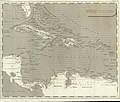
File:Arrowsmith - Map of the West Indies.jpg

Original file (5,880 × 5,010 pixels, file size: 5.22 MB, MIME type: image/jpeg)
Captions
Captions
Summary[edit]
| Artist |
artist QS:P170,Q301678 |
||||||||||||||||||||
| Publisher |
Cadell and Davies, Strand and Longman and Rees Paternoster Row |
||||||||||||||||||||
| Description |
English: A map of the world as seen from Florida to colonial Venezuela, which later became independent of Spain in 1811. |
||||||||||||||||||||
| Date |
1806 date QS:P571,+1806-00-00T00:00:00Z/9 |
||||||||||||||||||||
| Source/Photographer | http://tablespace.net/maps2/index.html | ||||||||||||||||||||
| Permission (Reusing this file) |
This file is licensed under the Creative Commons Attribution-Share Alike 2.0 Generic license. Attribution: William Favorite
|
||||||||||||||||||||
Licensing[edit]
| Public domainPublic domainfalsefalse |
|
This work is in the public domain in its country of origin and other countries and areas where the copyright term is the author's life plus 100 years or fewer. This work is in the public domain in the United States because it was published (or registered with the U.S. Copyright Office) before January 1, 1929. | |
| This file has been identified as being free of known restrictions under copyright law, including all related and neighboring rights. | |
https://creativecommons.org/publicdomain/mark/1.0/PDMCreative Commons Public Domain Mark 1.0falsefalse
| Annotations InfoField | This image is annotated: View the annotations at Commons |
File history
Click on a date/time to view the file as it appeared at that time.
| Date/Time | Thumbnail | Dimensions | User | Comment | |
|---|---|---|---|---|---|
| current | 07:59, 15 June 2021 |  | 5,880 × 5,010 (5.22 MB) | Aavindraa (talk | contribs) | Uploaded a work by {{Creator:Aaron Arrowsmith}} from http://tablespace.net/maps2/index.html with UploadWizard |
You cannot overwrite this file.
File usage on Commons
The following 2 pages use this file:
Metadata
This file contains additional information such as Exif metadata which may have been added by the digital camera, scanner, or software program used to create or digitize it. If the file has been modified from its original state, some details such as the timestamp may not fully reflect those of the original file. The timestamp is only as accurate as the clock in the camera, and it may be completely wrong.
| Orientation | Normal |
|---|---|
| Horizontal resolution | 300 dpi |
| Vertical resolution | 300 dpi |
| Software used | GIMP 2.10.24 |
| File change date and time | 03:50, 15 June 2021 |
| Color space | sRGB |
| Unique ID of original document | xmp.did:eb9e9f73-b914-421e-af7c-d333a9d3b96a |

