File:Arles centre-ville map-fr.svg
Jump to navigation
Jump to search

Size of this PNG preview of this SVG file: 800 × 508 pixels. Other resolutions: 320 × 203 pixels | 640 × 406 pixels | 1,024 × 650 pixels | 1,280 × 812 pixels | 2,560 × 1,624 pixels | 1,450 × 920 pixels.
Original file (SVG file, nominally 1,450 × 920 pixels, file size: 209 KB)
Captions
Captions
Add a one-line explanation of what this file represents
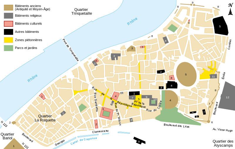
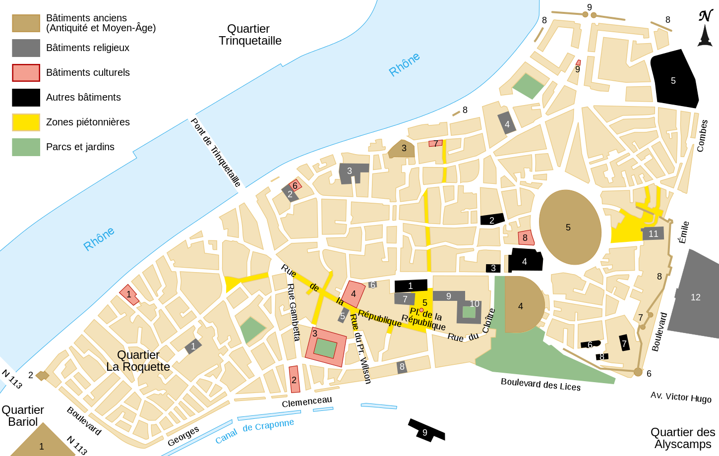
Picture keys[edit]
| 1 | Ruines du cirque romain | Église Saint-Césaire | Théâtre de la Calade | Hôtel de ville |
| 2 | Tour de l'écorchoir | Chapelle du Méjan | Théâtre d'Arles | École nationale de photo |
| 3 | Thermes de Constantin | Église des frères prêcheurs | Espace Van Gogh | Sous-préfecture |
| 4 | Théâtre antique | Église Saint-Julien | Musée de l'Arlaten | Collège Saint-Charles |
| 5 | Amphithéâtre | Chapelle des Trinitaires | Obélisque | Collège Frédéric Mistral |
| 6 | Tour des Mourgues | Chapelle des Jésuites | Cinéma du Méjan | Église Saint-Jean de Moustier |
| 7 | Porte d'Auguste | Chapelle Sainte Anne | Musée Réattu | Abbaye Saint-Césaire |
| 8 | Remparts | Temple Protestant | Fondation Van Gogh | Ancienne église Saint-Blaise |
| 9 | Porte de la cavalerie | Eglise Saint Trophime | Fontaine Amédée Pichot | Bourse du Travail |
| 10 | Cloître de Saint Trophime | |||
| 11 | Eglise de la Major | |||
| 12 | Cimetière de ville |
Summary[edit]
| Description | |||
| Date | |||
| Source | |||
| Author | Sémhur | ||
| Other versions | |||
| Attribution (required by the license) | © Sémhur / Wikimedia Commons / | ||
| SVG | W3C-validity not checked.
|
||
| Graphic Lab |

| Camera location | | View this and other nearby images on: OpenStreetMap |
|---|
Licensing[edit]
I, the copyright holder of this work, hereby publish it under the following licenses:
| Copyleft: This work of art is free; you can redistribute it and/or modify it according to terms of the Free Art License. You will find a specimen of this license on the Copyleft Attitude site as well as on other sites. |
This file is licensed under the Creative Commons Attribution-Share Alike 4.0 International, 3.0 Unported, 2.5 Generic, 2.0 Generic and 1.0 Generic license.
- You are free:
- to share – to copy, distribute and transmit the work
- to remix – to adapt the work
- Under the following conditions:
- attribution – You must give appropriate credit, provide a link to the license, and indicate if changes were made. You may do so in any reasonable manner, but not in any way that suggests the licensor endorses you or your use.
- share alike – If you remix, transform, or build upon the material, you must distribute your contributions under the same or compatible license as the original.
You may select the license of your choice.
File history
Click on a date/time to view the file as it appeared at that time.
| Date/Time | Thumbnail | Dimensions | User | Comment | |
|---|---|---|---|---|---|
| current | 11:18, 10 June 2008 | | 1,450 × 920 (209 KB) | Sémhur (talk | contribs) | Bon positionnement du quartier La Roquette |
| 18:54, 8 June 2008 |  | 1,450 × 920 (209 KB) | Sémhur (talk | contribs) | {{Information |Description={{en|1=Map of the town center of Arles, France.}} {{fr|1=Carte du centre-ville d'Arles, France.}} {{es|1=Mapa del centro de la cuidad de Arles, Francia.}} |Source=travail personnel (own |
You cannot overwrite this file.
File usage on Commons
The following page uses this file:
File usage on other wikis
The following other wikis use this file:
- Usage on en.wikipedia.org
- Usage on es.wikipedia.org
- Usage on fr.wikipedia.org
- Usage on zh.wikipedia.org