File:Arizona Scenic Road Marker.svg
Jump to navigation
Jump to search

Size of this PNG preview of this SVG file: 360 × 599 pixels. Other resolutions: 144 × 240 pixels | 288 × 480 pixels | 461 × 768 pixels | 615 × 1,024 pixels | 1,230 × 2,048 pixels | 1,624 × 2,704 pixels.
Original file (SVG file, nominally 1,624 × 2,704 pixels, file size: 11 KB)
Captions
Captions
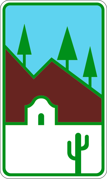
This is the winning design by Richard A. Dooley, who, at the time was a UofA art student. The contest, sponsored by ADOT had a total of 108 entries, from around the state.
Summary[edit]
| Description |
English: 18 in x 30 Scenic Road Marker used to identify Scenic Roads, Parkways and Historic Roads within the state of Arizona. Designed by Richard A. Dooley.Colors, sizes and dimensions all approximated from official ADOT file. |
| Date | |
| Source | [1] |
| Author | Matthew Anderson |
Licensing[edit]
This file is in the public domain because it comes from the Arizona Supplement to the Manual on Uniform Traffic Control Device for Streets and Highways, which states on p. AZ-i that "If a Section, Table, or Figure from the MUTCD is not contained within this Supplement, the section in the MUTCD shall remain unchanged." The federal MUTCD states specifically on its page I-1 that:
No provisions of the supplement supersede this provision of the MUTCD. |
File history
Click on a date/time to view the file as it appeared at that time.
| Date/Time | Thumbnail | Dimensions | User | Comment | |
|---|---|---|---|---|---|
| current | 00:58, 16 July 2023 | | 1,624 × 2,704 (11 KB) | MatthewAnderson707 (talk | contribs) | Shrank file size by deleting un-necessary geometry and fixed minor rendering issues. |
| 02:52, 9 July 2023 |  | 1,624 × 2,704 (11 KB) | MatthewAnderson707 (talk | contribs) | Fixed issues with the corners of the sign, resized page boundaries to fit cut off stroke areas and fixed gap between the green border and the saguaro. | |
| 05:51, 27 September 2018 |  | 1,620 × 2,700 (12 KB) | MatthewAnderson707 (talk | contribs) | User created page with UploadWizard |
You cannot overwrite this file.
File usage on Commons
The following 3 pages use this file:
File usage on other wikis
The following other wikis use this file:
- Usage on en.wikipedia.org
- List of state routes in Arizona
- Arizona State Route 85
- Arizona State Route 89A
- U.S. Route 89A
- Catalina Highway
- Arizona State Route 82
- Arizona State Route 77
- Arizona State Route 83
- Arizona State Route 88
- Arizona State Route 260
- Arizona State Route 73
- Arizona State Route 288
- Arizona State Route 177
- Arizona State Route 98
- Arizona State Route 261
- Arizona State Route 273
- Arizona State Route 366
- U.S. Route 60 in Arizona
- U.S. Route 191 in Arizona
- U.S. Route 93 in Arizona
- User talk:MatthewAnderson707/sandbox
- Usage on en.wikivoyage.org
- Usage on www.wikidata.org