File:Arisdorf, Luftaufnahme 2022.jpg
Jump to navigation
Jump to search

Size of this preview: 800 × 599 pixels. Other resolutions: 320 × 240 pixels | 640 × 479 pixels | 1,024 × 767 pixels | 1,280 × 958 pixels | 2,500 × 1,872 pixels.
Original file (2,500 × 1,872 pixels, file size: 1.75 MB, MIME type: image/jpeg)
Captions
Captions
Add a one-line explanation of what this file represents
Summary[edit]
| Description |
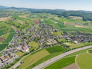
Deutsch: Luftaufnahme von Arisdorf 2022 im Vergleich zur Aufnahme von 1940 zeigt den Landschaftswandel. Die einst zahlreichen Obstbäume sind nur noch spärlich vorhanden. |
| Date | |
| Source | www.regionatur.ch |
| Author | Beat Ernst, Basel |
| Camera location | | View this and other nearby images on: OpenStreetMap |
|---|
Licensing[edit]
This file is licensed under the Creative Commons Attribution-Share Alike 4.0 International license.
- You are free:
- to share – to copy, distribute and transmit the work
- to remix – to adapt the work
- Under the following conditions:
- attribution – You must give appropriate credit, provide a link to the license, and indicate if changes were made. You may do so in any reasonable manner, but not in any way that suggests the licensor endorses you or your use.
- share alike – If you remix, transform, or build upon the material, you must distribute your contributions under the same or compatible license as the original.
File history
Click on a date/time to view the file as it appeared at that time.
| Date/Time | Thumbnail | Dimensions | User | Comment | |
|---|---|---|---|---|---|
| current | 06:40, 8 November 2023 | | 2,500 × 1,872 (1.75 MB) | Meiermuttenz (talk | contribs) | Uploaded a work by Beat Ernst, Basel from www.regionatur.ch with UploadWizard |
You cannot overwrite this file.
File usage on Commons
There are no pages that use this file.
File usage on other wikis
The following other wikis use this file:
- Usage on de.wikipedia.org