File:Argos, Western Road - geograph.org.uk - 211915.jpg
From Wikimedia Commons, the free media repository
Jump to navigation
Jump to search
Argos,_Western_Road_-_geograph.org.uk_-_211915.jpg (640 × 479 pixels, file size: 188 KB, MIME type: image/jpeg)
File information
Structured data
Captions
Captions
Add a one-line explanation of what this file represents
Summary[edit]
| DescriptionArgos, Western Road - geograph.org.uk - 211915.jpg |
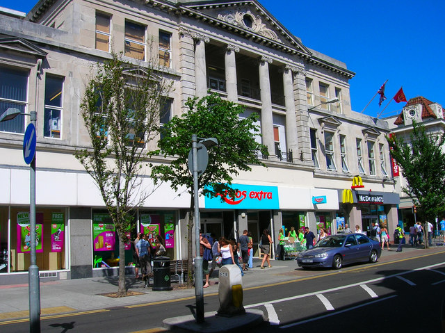
English: Argos, Western Road. At the bottom of Victoria Street turn east along Upper North Street then south down Spring Street until you Western Road again. Originally the road was a track that connected Brighton to Hove church and the road gradually began to be developed from the 1830s as the new terraces and squares by the sea extended westwards. By the 1860s it had become a major shopping street servicing the great, good and not so good in their day to day urban life. By the early part of the twentieth century the road had become clogged with the traffic and was subsequently widened piecemeal between 1926-36. The demolition took place on the northern side and it is here that the reproductions of Selfridges in London along with art deco designs occurred. This building was constructed in the 1930s for Staffords and in the last 20 years has been home to Fads, Virgin Megastore and since 1998 Argos who originally occupied just the west wing of the building.
Click on the link to take you to the next page. https://www.geograph.org.uk/photo/211917 |
| Date | |
| Source | From geograph.org.uk |
| Author | Simon Carey |
| Attribution (required by the license) InfoField | Simon Carey / Argos, Western Road / |
InfoField | Simon Carey / Argos, Western Road |
| Camera location | 50° 49′ 26″ N, 0° 08′ 56″ W | View this and other nearby images on: OpenStreetMap |
|---|
| Object location | 50° 49′ 30″ N, 0° 08′ 56″ W | View this and other nearby images on: OpenStreetMap |
|---|
Licensing[edit]

|
This image was taken from the Geograph project collection. See this photograph's page on the Geograph website for the photographer's contact details. The copyright on this image is owned by Simon Carey and is licensed for reuse under the Creative Commons Attribution-ShareAlike 2.0 license.
|
This file is licensed under the Creative Commons Attribution-Share Alike 2.0 Generic license.
Attribution: Simon Carey
- You are free:
- to share – to copy, distribute and transmit the work
- to remix – to adapt the work
- Under the following conditions:
- attribution – You must give appropriate credit, provide a link to the license, and indicate if changes were made. You may do so in any reasonable manner, but not in any way that suggests the licensor endorses you or your use.
- share alike – If you remix, transform, or build upon the material, you must distribute your contributions under the same or compatible license as the original.
File history
Click on a date/time to view the file as it appeared at that time.
| Date/Time | Thumbnail | Dimensions | User | Comment | |
|---|---|---|---|---|---|
| current | 20:05, 31 January 2010 |  | 640 × 479 (188 KB) | GeographBot (talk | contribs) | == {{int:filedesc}} == {{Information |description={{en|1=Argos, Western Road. At the bottom of Victoria Street turn east along Upper North Street then south down Spring Street until you Western Road again. Originally the road was a track that connected Br |
You cannot overwrite this file.
File usage on Commons
There are no pages that use this file.
Metadata
This file contains additional information such as Exif metadata which may have been added by the digital camera, scanner, or software program used to create or digitize it. If the file has been modified from its original state, some details such as the timestamp may not fully reflect those of the original file. The timestamp is only as accurate as the clock in the camera, and it may be completely wrong.
| Camera manufacturer | NIKON |
|---|---|
| Camera model | E4600 |
| Exposure time | 151,011/100,000,000 sec (0.00151011) |
| F-number | f/4.9 |
| ISO speed rating | 50 |
| Date and time of data generation | 15:23, 30 July 2006 |
| Lens focal length | 5.7 mm |
| Orientation | Normal |
| Horizontal resolution | 300 dpi |
| Vertical resolution | 300 dpi |
| Software used | PictureProject 1.1.0 M |
| File change date and time | 19:19, 30 July 2006 |
| Y and C positioning | Centered |
| Exposure Program | Normal program |
| Exif version | 2.2 |
| Date and time of digitizing | 15:23, 30 July 2006 |
| APEX exposure bias | 0 |
| Maximum land aperture | 3 APEX (f/2.83) |
| Metering mode | Pattern |
| Light source | Unknown |
| Flash | Flash did not fire, auto mode |
| Color space | sRGB |
