File:Argon-Field-katavothra Peloponnese Greece.jpg
Jump to navigation
Jump to search
Size of this preview: 800 × 533 pixels. Other resolutions: 320 × 213 pixels | 640 × 427 pixels | 1,024 × 683 pixels | 1,280 × 853 pixels | 1,800 × 1,200 pixels.
Original file (1,800 × 1,200 pixels, file size: 3.27 MB, MIME type: image/jpeg)
Captions
Captions
Add a one-line explanation of what this file represents
Summary[edit]
| Description |
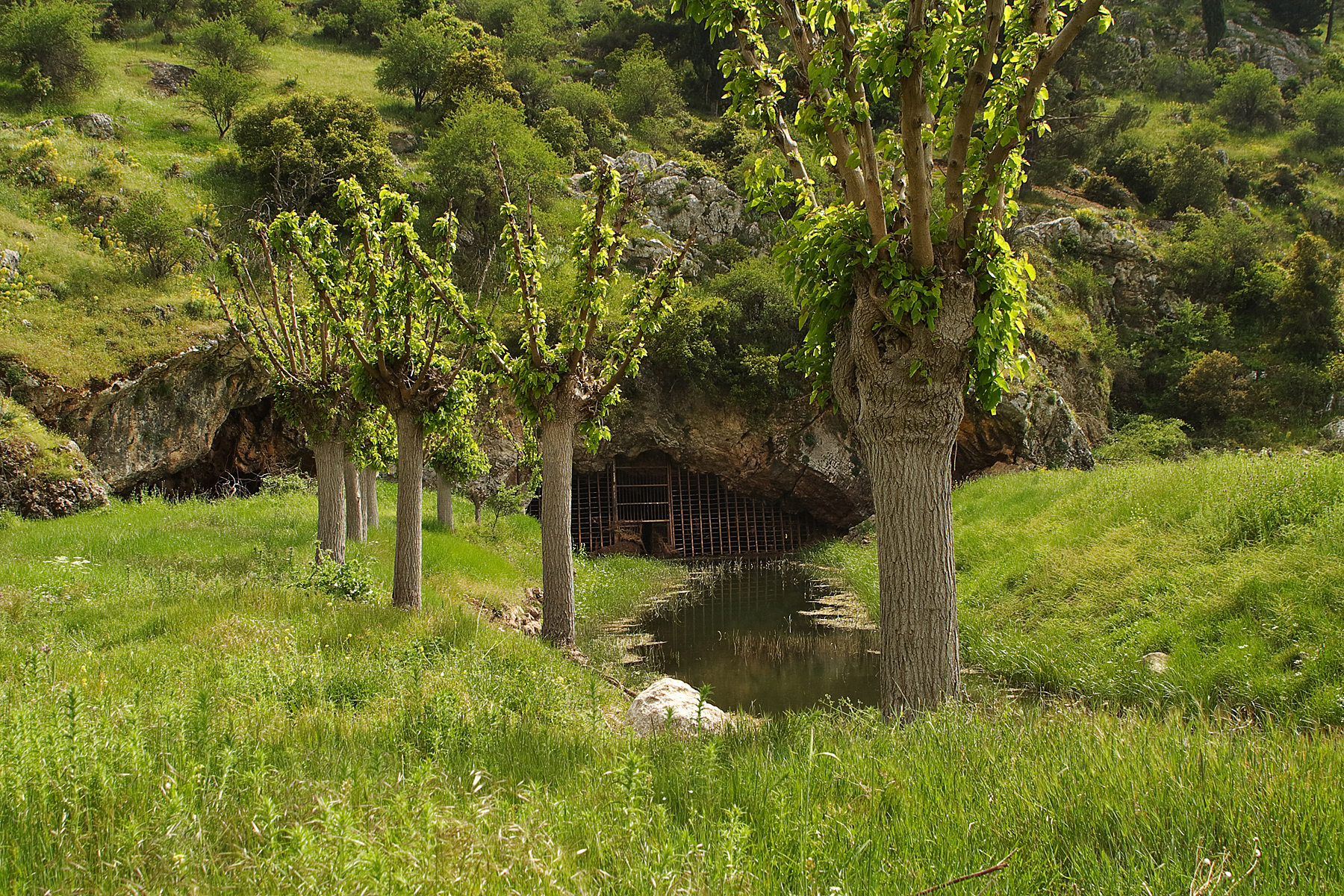
Ελληνικά: Το μοναδικό καταβόθρα (English: ponor) του μήκους περίπου 5 Χμ πολπε „Αργόν Πεδίον“ πήρε το όνομά του από τον Παυσανίας (160 μ. Χρ.). Μερικές φορές πολύ άφθονη βροχόπτωση τροφοδοτείται στο καταβόθρα μέσω μιας σειράς τάφρων αποστράγγισης στο κοίλο σχήμα του καρστικού τοπίου, το οποίο είναι κλειστό από όλες τις πλευρές. Μετά από περίπου 30 χμ σε υπόγειες πλωτές οδούς, το νερό επανεμφανίζεται σε μια πολύ μεγάλη υποθαλάσσια πηγή "Ανάβαλος" ακριβώς στην παραλιακή άκρη του Αργολικού Κόλπου. Οι κάτοικοι του χωριού Νεστάνη, στο νότιο άκρο Άγρον Πεδίον, αφήνουν τα κοπάδια των αιγοπροβάτων να βόσκουν στα βοσκοτόπια τους.
English: Single Ponor of a ca. 5 km long polje. The polje’s name Argón Pedíon (“untilled field”) is preserved in the book “Description of Greece, Book 8, Arcadia” (ca. 160 A.D.), Pausanias. The polje has no surface outflow.
A row of drainage ditches and meandering furrows drain the plain, unless precipitation was so excessive that a temporary lake forms. The ponor’s run-off, whether inhibited by debris or even clogged, determinates the lake’s disappearance. After ca. 30 km, subsurface, the waters emerge again in a large coastal spring called “Anavalos”. Deutsch: Einziger Ponor einer ca. 5 km langen Polje. Die Polje wurde schon von dem antiken Schriftsteller ]Pausanias (ca. 160 AD) in seinen Dokumenten „Beschreibung Griechenlands, Buch VIII Arkadien“ überliefert. Er nannte die Polje „Argón Pedíon“ („Faules Feld“). Zuweilen zu reichlich anfallende Niederschläge werden in der allseits geschlossenen Karst-Hohlform dann als temporärer See gespeichert und in einer natürlichen Furche und einer Reihe Entwässerungsgräben dem Ponor - dessen jeweiliger Abflussleistung gemäß – zugeführt. Nach ca. 30 km, unterirdisch, kommt das Wasser in einer sehr großen Unterseeischen Quelle („Dine“), unmittelbar am Küstensaum des Argolischen Golfs wieder ans Tageslicht. Foto der Polje: Image:Argon-Field-Panorama_Peloponnese_Greece.jpg. |
| Date | |
| Source | Own work |
| Author | Ulrichstill |
Licensing[edit]
I, the copyright holder of this work, hereby publish it under the following license:
This file is licensed under the Creative Commons Attribution-Share Alike 4.0 International license.
- You are free:
- to share – to copy, distribute and transmit the work
- to remix – to adapt the work
- Under the following conditions:
- attribution – You must give appropriate credit, provide a link to the license, and indicate if changes were made. You may do so in any reasonable manner, but not in any way that suggests the licensor endorses you or your use.
- share alike – If you remix, transform, or build upon the material, you must distribute your contributions under the same or compatible license as the original.
File history
Click on a date/time to view the file as it appeared at that time.
| Date/Time | Thumbnail | Dimensions | User | Comment | |
|---|---|---|---|---|---|
| current | 09:05, 19 October 2022 | | 1,800 × 1,200 (3.27 MB) | Ulrichstill (talk | contribs) | Uploaded own work with UploadWizard |
You cannot overwrite this file.
File usage on Commons
There are no pages that use this file.