File:Argentinien topo.jpg
Jump to navigation
Jump to search

Size of this preview: 445 × 599 pixels. Other resolutions: 178 × 240 pixels | 357 × 480 pixels | 571 × 768 pixels | 761 × 1,024 pixels | 1,600 × 2,153 pixels.
Original file (1,600 × 2,153 pixels, file size: 599 KB, MIME type: image/jpeg)
Captions
Captions
Add a one-line explanation of what this file represents
Summary[edit]
| Description |
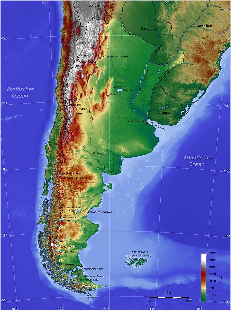
Deutsch: Topografische Karte von Argentinien |
| Date | 25 May 2005 (original upload date); 10 May 2008 (last version) |
| Source |
Own work using Generic Mapping Tools (http://gmt.soest.hawaii.edu/)
|
| Author |
Captain Blood at de.wikipedia. Later version(s) were uploaded by Antipatico at de.wikipedia. |
Licensing[edit]
Captain Blood at the German-language Wikipedia, the copyright holder of this work, hereby publishes it under the following license:

|
Permission is granted to copy, distribute and/or modify this document under the terms of the GNU Free Documentation License, Version 1.2 or any later version published by the Free Software Foundation; with no Invariant Sections, no Front-Cover Texts, and no Back-Cover Texts. A copy of the license is included in the section entitled GNU Free Documentation License. |
| This file is licensed under the Creative Commons Attribution-Share Alike 3.0 Unported license. | ||
| Attribution: Captain Blood | ||
| ||
| This licensing tag was added to this file as part of the GFDL licensing update. |
Original upload log[edit]
The original description page was here. All following user names refer to de.wikipedia.
- 2008-05-10 21:12 Antipatico 1600×2153× (613178 bytes) {{Bild-GFDL}} {| {{Lizenzdesign4}} | Bei der Erstellung der Landkarte wurden die '''Generic Mapping Tools''' verwendet: http://gmt.soest.hawaii.edu/ Für das Relief - falls vorhanden - wurde(n) einer oder mehrere dieser externen [[Public Domain]]-Datens�
- 2005-05-25 13:49 Captain Blood 1600×2153× (944368 bytes)
- 2005-05-25 13:40 Captain Blood 1600×2153× (944447 bytes)
File history
Click on a date/time to view the file as it appeared at that time.
| Date/Time | Thumbnail | Dimensions | User | Comment | |
|---|---|---|---|---|---|
| current | 01:38, 12 June 2011 | | 1,600 × 2,153 (599 KB) | File Upload Bot (Magnus Manske) (talk | contribs) | {{BotMoveToCommons|de.wikipedia|year={{subst:CURRENTYEAR}}|month={{subst:CURRENTMONTHNAME}}|day={{subst:CURRENTDAY}}}} {{Information |Description={{de|{| | Bei der Erstellung der Landkarte wurden die '''Generic Mapping Tools''' verwendet: http://gmt.soe |
You cannot overwrite this file.
File usage on Commons
There are no pages that use this file.
File usage on other wikis
The following other wikis use this file:
- Usage on bg.wikipedia.org
- Usage on cs.wikipedia.org
- Usage on da.wikipedia.org
- Usage on de.wikipedia.org
- Usage on ru.wikipedia.org
- Usage on stq.wikipedia.org