File:Argentina regions map.png
Jump to navigation
Jump to search

Size of this preview: 345 × 600 pixels. Other resolutions: 138 × 240 pixels | 276 × 480 pixels | 442 × 768 pixels | 589 × 1,024 pixels | 1,731 × 3,008 pixels.
Original file (1,731 × 3,008 pixels, file size: 927 KB, MIME type: image/png)
Captions
Captions
Add a one-line explanation of what this file represents
Summary[edit]
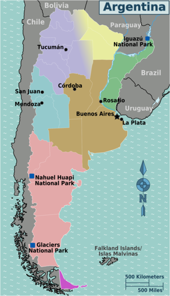
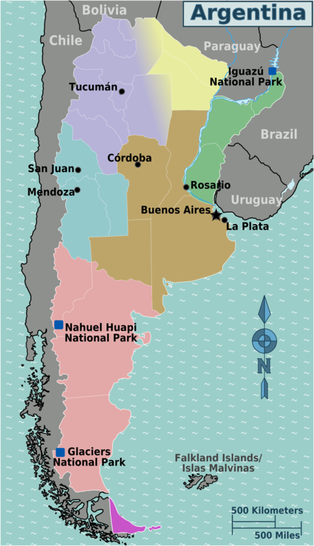
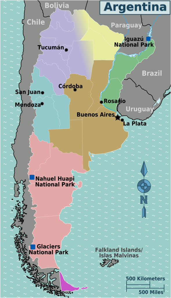
| Description | Regional map of Argentina (Wikivoyage regional scheme), English version |
| Date | |
| Source | own work based on the blank map of regions and CIA WFB map |
| Author | Peter Fitzgerald, minor amendments by Cacahuate |
| Other versions |
.png)
.png)
.png)
Licensing[edit]
This file is licensed under the Creative Commons Attribution-Share Alike 3.0 Unported license.
- You are free:
- to share – to copy, distribute and transmit the work
- to remix – to adapt the work
- Under the following conditions:
- attribution – You must give appropriate credit, provide a link to the license, and indicate if changes were made. You may do so in any reasonable manner, but not in any way that suggests the licensor endorses you or your use.
- share alike – If you remix, transform, or build upon the material, you must distribute your contributions under the same or compatible license as the original.
Original upload log[edit]
| This file was imported from Wikivoyage WTS. |
The original description page was here. All following user names refer to wts.wikivoyage-old.
- 2008-08-26 05:02 (WT-shared) Peterfitzgerald archive copy at the Wayback Machine 1731×3008 (949714 bytes) {{Imagecredit|credit=Peter Fitzgerald|captureDate=25 August 2008|location=Argentina|source=[[:Image:Argentina regions map.svg]]|caption=Arge (Import from wikitravel.org/shared)
- 2009-06-08 02:05 (WT-shared) Cacahuate[dead link] 568×992 (233634 bytes) minor - black borders to white, etc (Import from wikitravel.org/shared)
File history
Click on a date/time to view the file as it appeared at that time.
| Date/Time | Thumbnail | Dimensions | User | Comment | |
|---|---|---|---|---|---|
| current | 10:26, 1 March 2022 | | 1,731 × 3,008 (927 KB) | Turbo Slayer 2021 (talk | contribs) | Clearer Verison |
| 10:37, 18 November 2012 |  | 568 × 992 (228 KB) | OgreBot (talk | contribs) | (BOT): Reverting to most recent version before archival | |
| 10:37, 18 November 2012 |  | 1,731 × 3,008 (927 KB) | OgreBot (talk | contribs) | (BOT): Uploading old version of file from wts.wikivoyage-old; originally uploaded on 2008-08-26 05:02:42 by (WT-shared) Peterfitzgerald | |
| 21:48, 17 November 2012 |  | 568 × 992 (228 KB) | MGA73bot2 (talk | contribs) | {{BotMoveToCommons|wts.oldwikivoyage|year={{subst:CURRENTYEAR}}|month={{subst:CURRENTMONTHNAME}}|day={{subst:CURRENTDAY}}}} == {{int:filedesc}} == {{Information |description=Argentina regions map. English version, Argentina * Map of: Argentina¤ |date=... |
You cannot overwrite this file.
File usage on Commons
The following 2 pages use this file:
File usage on other wikis
The following other wikis use this file:
- Usage on el.wikivoyage.org
- Usage on en.wikipedia.org
- Usage on en.wikivoyage.org
- Usage on he.wikivoyage.org
- Usage on incubator.wikimedia.org
- Usage on it.wikivoyage.org
- Usage on ja.wikivoyage.org
- Usage on nl.wikivoyage.org
- Usage on uz.wikipedia.org
- Usage on vi.wikivoyage.org
- Usage on zh.wikivoyage.org