File:Argentina - Mapa fitogeográfico (Parodi 1934).svg
Jump to navigation
Jump to search

Size of this PNG preview of this SVG file: 352 × 599 pixels. Other resolutions: 141 × 240 pixels | 282 × 480 pixels | 451 × 768 pixels | 602 × 1,024 pixels | 1,204 × 2,048 pixels | 1,418 × 2,412 pixels.
Original file (SVG file, nominally 1,418 × 2,412 pixels, file size: 1.32 MB)
Captions
Captions
Add a one-line explanation of what this file represents
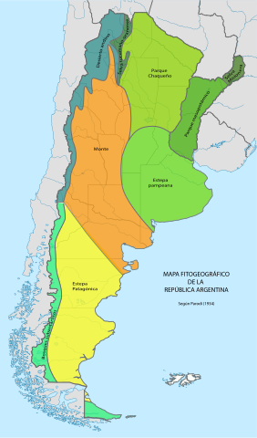
| Description | Mapa fitogeográfico de la República Argentina, según L.R. Parodi (1934). Regiones: Selva misionera, Selva tucumano-oranense, Parque chaqueño, Parque mesopotámico, Estepa pampeana, Monte, Estepa patagónica, Bosques subantárticos, Desierto andino. |
| Date | |
| Source |
L.R. Parodi (1934), Las Plantas Indígenas no Alimenticias cultivadas en la Argentina. Revista Argentina de Agronomía I(3):165-212, Buenos Aires. Tomado de Ratera y Ratera (1980) Plantas de la Flora Argentina empleadas en medicina popular, tomado a su vez de Geografía de la República Argentina, GAEA, t. VIII:13,1947-1950, Buenos Aires. This vector image includes elements that have been taken or adapted from this file: This vector image includes elements that have been taken or adapted from this file: |
| Author | Map by Gustavo Girardelli (derivative from NordNordWest), derivative work by User:RoRo. Information taken from L.R. Parodi (1934). |
| Permission (Reusing this file) |
I, the copyright holder of this work, hereby publish it under the following license: This file is licensed under the Creative Commons Attribution-Share Alike 4.0 International license.
|
.svg)
File history
Click on a date/time to view the file as it appeared at that time.
| Date/Time | Thumbnail | Dimensions | User | Comment | |
|---|---|---|---|---|---|
| current | 16:47, 21 June 2015 | | 1,418 × 2,412 (1.32 MB) | Yann (talk | contribs) | Reverted to version as of 20:01, 18 April 2015 |
| 22:07, 28 May 2015 |  | 512 × 872 (1.39 MB) | Janitoalevic (talk | contribs) | * Agregado el Límite Indefinido de los Campos de hielo Patagónico Sur, vigente desde 1998, Para Más información visitar: https://es.wikipedia.org/wiki/Campo_de_hielo_Patag%C3%B3nico_Sur#Zona_lim.C3.ADtrofe_no_demarcada * Corregido Color Verde y Am... | |
| 20:01, 18 April 2015 |  | 1,418 × 2,412 (1.32 MB) | RoRo (talk | contribs) | {{Information |Description=Mapa fitogeográfico de la República Argentina, según L.R. Parodi (1934). Regiones: Selva misionera, Selva tucumano-oranense, Parque chaqueño, Parque mesopotámico, Estepa pampeana, Monte, Estepa patagónica, Bosques suban... |
You cannot overwrite this file.
File usage on Commons
There are no pages that use this file.
File usage on other wikis
The following other wikis use this file:
- Usage on es.wikipedia.org
.svg&oldid=801216673)