File:Areas of control, 20 October 1995 - (Bosnia and Hercegovina with Croatia). LOC 2009584259.jpg
Jump to navigation
Jump to search

Size of this preview: 581 × 600 pixels. Other resolutions: 232 × 240 pixels | 465 × 480 pixels | 744 × 768 pixels | 992 × 1,024 pixels | 1,984 × 2,048 pixels | 7,523 × 7,767 pixels.
Original file (7,523 × 7,767 pixels, file size: 8.2 MB, MIME type: image/jpeg)
Captions
Captions
Add a one-line explanation of what this file represents
Summary[edit]
| Description |
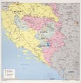
English: Shows Serbian/Croatian/Muslim areas of control and UN-declared safe/patrolled areas. Also shows control areas in Croatia including UN sectors. "737414 (R00855) 10-95." Includes note. Available also through the Library of Congress Web site as a raster image. |
||
| Title | Areas of control, 20 October 1995 : [Bosnia and Hercegovina with Croatia]. | ||
| Shelf ID | G6861.F7 1995 .U4 | ||
| Date | |||
| Source | https://www.loc.gov/item/2009584259/ | ||
| Author | United States. Central Intelligence Agency | ||
| Permission (Reusing this file) |
|
||
| Other versions |
|
||
| Location | Herzegovina · Croatia · Bosnia And Herzegovina · Bosnia | ||
| Part of | American Memory · General Maps · Catalog · Geography And Map Division | ||
| Subject | Jurisdiction, Territorial · Ethnology · Peacekeeping Forces · Partition · Maps · Croatia · Bosnia And Herzegovina · Administrative And Political Divisions · United Nations · History |

._LOC_2009584259.jpg&action=edit§ion=1)
Licensing[edit]
._LOC_2009584259.jpg&action=edit§ion=2)
| This image is a work of a Central Intelligence Agency employee, taken or made as part of that person's official duties. As a Work of the United States Government, this image or media is in the public domain in the United States.
|

|
File history
Click on a date/time to view the file as it appeared at that time.
| Date/Time | Thumbnail | Dimensions | User | Comment | |
|---|---|---|---|---|---|
| current | 07:11, 14 June 2018 | | 7,523 × 7,767 (8.2 MB) | Fæ (talk | contribs) | LOC Maps https://www.loc.gov/item/2009584259/ #15062 |
You cannot overwrite this file.
File usage on Commons
The following page uses this file:
File usage on other wikis
The following other wikis use this file:
- Usage on de.wikipedia.org
- Usage on hu.wikipedia.org
._LOC_2009584259.jpg&oldid=801158747)