File:Areas named karoo.png
Jump to navigation
Jump to search
Size of this preview: 649 × 599 pixels. Other resolutions: 260 × 240 pixels | 520 × 480 pixels | 832 × 768 pixels | 1,109 × 1,024 pixels | 1,578 × 1,457 pixels.
Original file (1,578 × 1,457 pixels, file size: 2.29 MB, MIME type: image/png)
Captions
Captions
Add a one-line explanation of what this file represents
Summary[edit]
| Description |
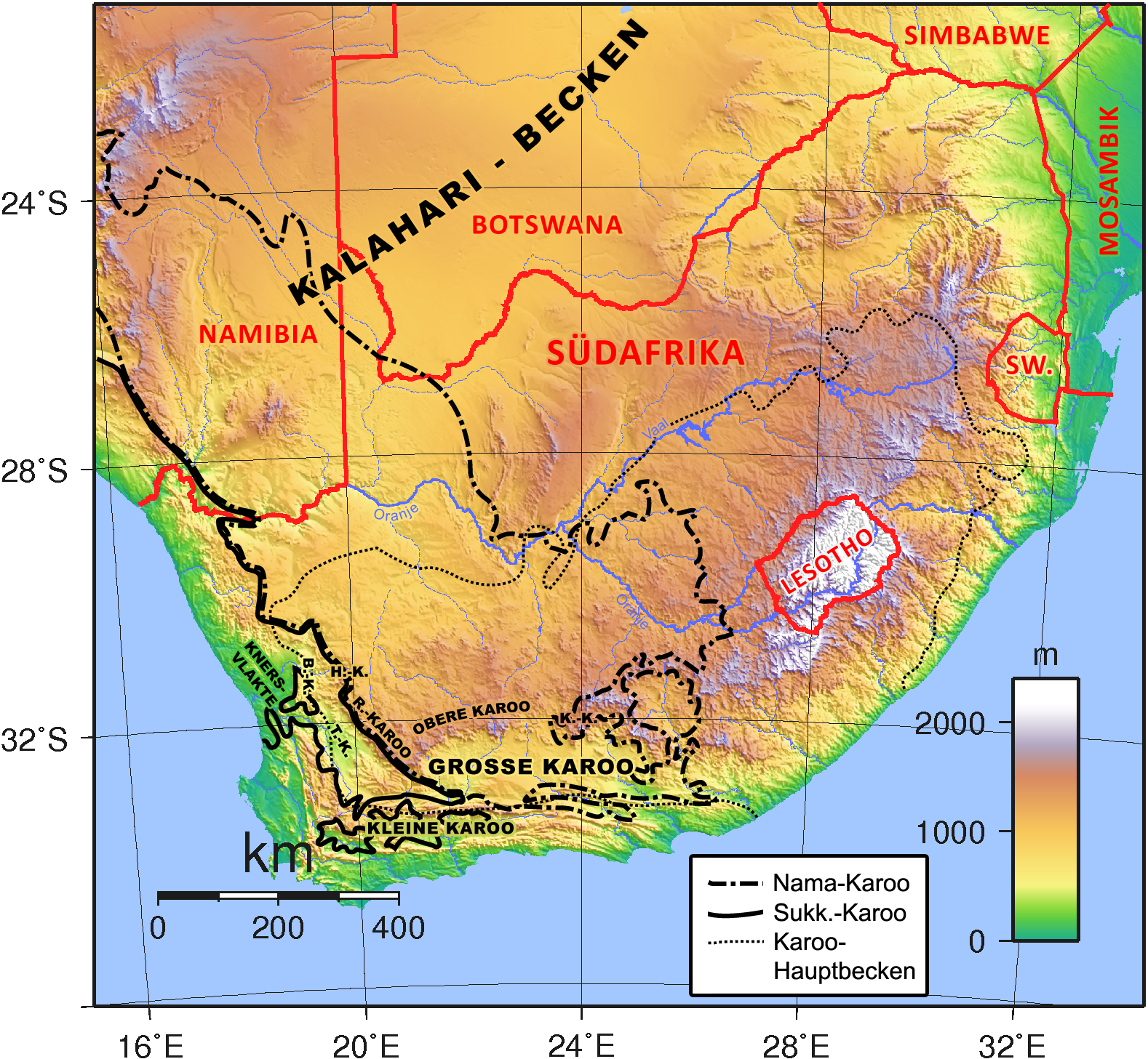
English: Map of southern Africa showing different areas to which the name "Karoo" is applied. Abbreviations: B.-K. = Bokkeveld Karoo, H.-K. = Hantam Karoo, K.-K. = Kamdeboo Karoo, R.-Karoo = Roggeveld Karoo, SW. = Eswatini, T.-K. = Tanqua Karoo.
Deutsch: Karte des südlichen Afrikas mit verschiedenen Regionen, für die der Name "Karoo" genutzt wird. Abkürzungen: B.-K. = Bokkeveld-Karoo, H.-K. = Hantam-Karoo, K.-K. = Kamdeboo-Karoo, R.-Karoo = Roggeveld-Karoo, SW. = Eswatini, T.-K. = Tanqua-Karoo. |
| Date | |
| Source | Own work; map is based on this image by Sadalmelik. Outlines of Karoo biomes are according to Rutherford & Westfall (1986)[1], outline of Main Karoo Basin is according to Catuneanu et al. (2005)[2] |
| Author | Gretarsson |
References[edit]
- ↑ M.C. Rutherford, R.H. Westfall (1986): Biomes of Southern Africa — an objective categorisation. Memoirs of the Botanical Survey of South Africa, vol. 54, pp. 1–98
- ↑ O. Catuneanu, H. Wopfner, P.G. Eriksson et al. (2005): The Karoo basins of south-central Africa. Journal of African Earth Sciences, vol. 43, pp. 211–253 (pdf, 3 MB)
Licensing[edit]
I, the copyright holder of this work, hereby publish it under the following licenses:

|
Permission is granted to copy, distribute and/or modify this document under the terms of the GNU Free Documentation License, Version 1.2 or any later version published by the Free Software Foundation; with no Invariant Sections, no Front-Cover Texts, and no Back-Cover Texts. A copy of the license is included in the section entitled GNU Free Documentation License. |
This file is licensed under the Creative Commons Attribution-Share Alike 3.0 Unported, 2.5 Generic, 2.0 Generic and 1.0 Generic license.
- You are free:
- to share – to copy, distribute and transmit the work
- to remix – to adapt the work
- Under the following conditions:
- attribution – You must give appropriate credit, provide a link to the license, and indicate if changes were made. You may do so in any reasonable manner, but not in any way that suggests the licensor endorses you or your use.
- share alike – If you remix, transform, or build upon the material, you must distribute your contributions under the same or compatible license as the original.
You may select the license of your choice.
File history
Click on a date/time to view the file as it appeared at that time.
| Date/Time | Thumbnail | Dimensions | User | Comment | |
|---|---|---|---|---|---|
| current | 02:31, 9 January 2013 | | 1,578 × 1,457 (2.29 MB) | Gretarsson (talk | contribs) | borders of biomes refined |
| 03:31, 8 January 2013 |  | 1,578 × 1,457 (2.3 MB) | Gretarsson (talk | contribs) | changed outline colours of karoo biomes to black due to better contrast | |
| 17:29, 7 January 2013 |  | 1,578 × 1,457 (2.3 MB) | Gretarsson (talk | contribs) | {{Information |Description ={{en|1=Map of southern Africa showing different areas to which the name "Karoo" is applied. Abbreviations: B.-K. = Bokkeveld Karoo, H.-K. = Hantam Karoo, R.-Karoo = Roggeveld Karoo, T.-K. = Tanqua Karoo.}} {{de|1=Karte de... |
You cannot overwrite this file.
File usage on Commons
The following page uses this file: