File:Arctic lt.svg
Jump to navigation
Jump to search

Size of this PNG preview of this SVG file: 478 × 599 pixels. Other resolutions: 191 × 240 pixels | 383 × 480 pixels | 613 × 768 pixels | 817 × 1,024 pixels | 1,634 × 2,048 pixels | 505 × 633 pixels.
Original file (SVG file, nominally 505 × 633 pixels, file size: 1.5 MB)
Captions
Captions
Add a one-line explanation of what this file represents
Summary[edit]
| Description |
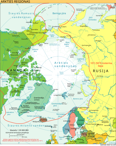
Lietuvių: Arkties žemėlapis.
Македонски: Карта на Арктикот.
English: Map of the Arctic. |
| Source | |
| Author |
|
| Other versions |
[]
|


.svg)


Licensing[edit]
This image is in the public domain because it contains materials that originally came from the United States Central Intelligence Agency's World Factbook.
|
 |
File history
Click on a date/time to view the file as it appeared at that time.
| Date/Time | Thumbnail | Dimensions | User | Comment | |
|---|---|---|---|---|---|
| current | 20:40, 5 April 2011 | | 505 × 633 (1.5 MB) | Hugo.arg (talk | contribs) | {{Information |Description= {{lt|Arkties žemėlapis.}} {{mk|Карта на Арктикот.}} {{en|Map of the Arctic.}} |Source=*Arctic.svg |Date= |Author=*Arctic.svg: [[User:Ysangkok| |
You cannot overwrite this file.
File usage on Commons
The following 16 pages use this file:
- File:Arctic-es.svg
- File:Arctic-fr.svg
- File:Arctic-hr.svg
- File:Arctic-mk.svg
- File:Arctic-sr.svg
- File:Arctic.svg
- File:Arctic Routes (RUS).svg
- File:Arctic circle.svg
- File:Arctic circle mk.svg
- File:Arctic de.svg
- File:Arctic hi.svg
- File:Arctic lt.svg
- File:Arktika-hsb.svg
- File:سرزمین شمالگان.svg
- File:مدار شمالگان.svg
- Template:Other versions/Arctic
File usage on other wikis
The following other wikis use this file:
- Usage on lt.wikipedia.org