File:Arches National Park Map.jpg
Jump to navigation
Jump to search
Size of this preview: 400 × 600 pixels. Other resolutions: 160 × 240 pixels | 320 × 480 pixels | 512 × 768 pixels | 682 × 1,024 pixels | 2,500 × 3,750 pixels.
Original file (2,500 × 3,750 pixels, file size: 3.52 MB, MIME type: image/jpeg)
Captions
Captions
Add a one-line explanation of what this file represents
|
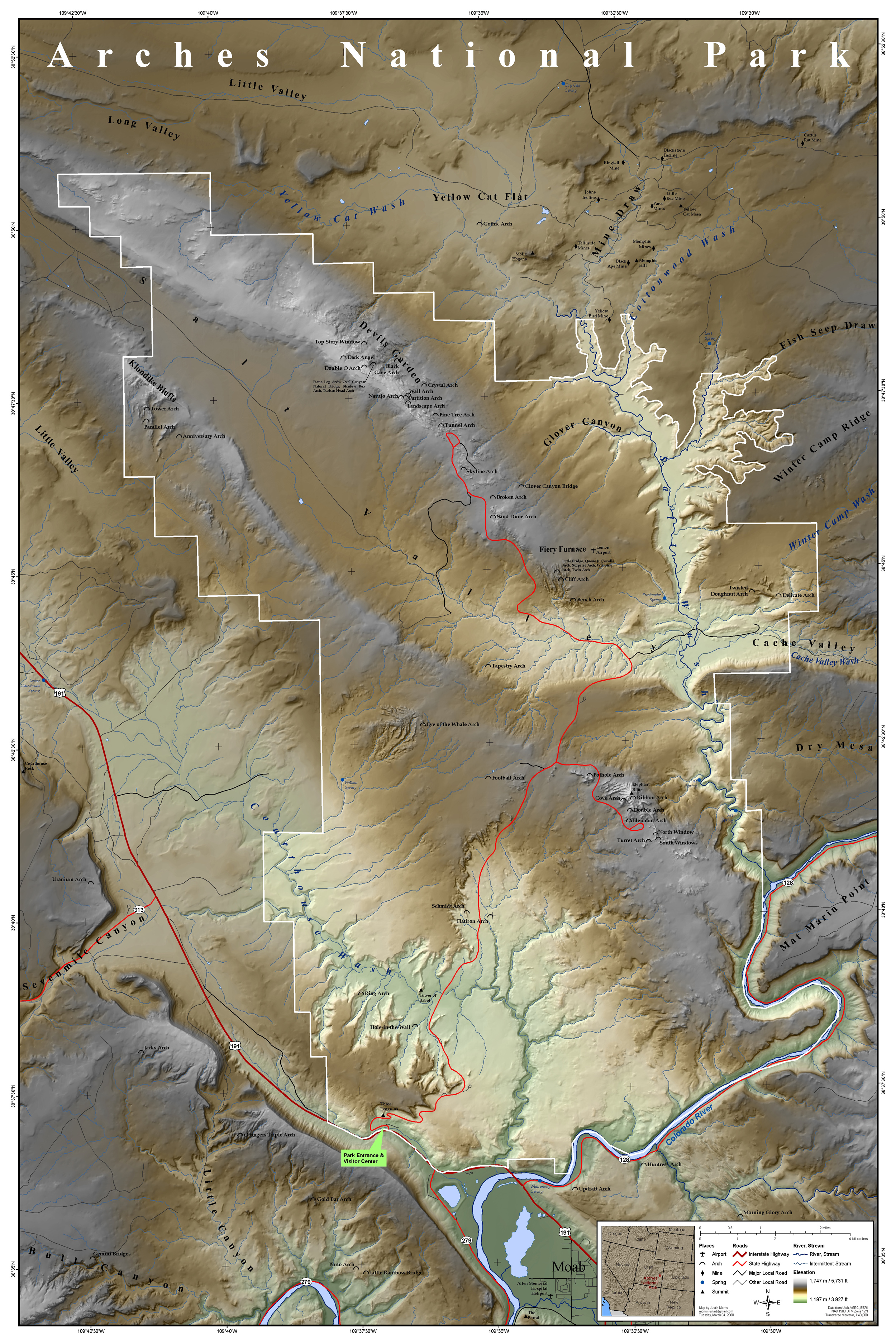
| Description | Map of Arches National Park, Utah, United States showing predominant features such as arches, peaks, rivers and streams, mines, and roads. | ||
| Date | |||
| Source | This map was entirely self made using ArcGIS. Map data is from Utah AGRC, ESRI and the USGS. | ||
| Author | Justinmorris (talk) | ||
| Permission (Reusing this file) |
I, the copyright holder of this work, hereby publish it under the following license: This file is licensed under the Creative Commons Attribution-Share Alike 3.0 Unported license.
|
File history
Click on a date/time to view the file as it appeared at that time.
| Date/Time | Thumbnail | Dimensions | User | Comment | |
|---|---|---|---|---|---|
| current | 17:15, 16 March 2008 | | 2,500 × 3,750 (3.52 MB) | Justinmorris (talk | contribs) | {{FeaturedPicture|Arches National Park Map}} == Summary == {{Information |Description=Map of Arches National Park, Utah, United States showing predominant features such as arches, peaks, rivers and streams, mines, and roads. |S |
You cannot overwrite this file.
File usage on Commons
The following page uses this file:
File usage on other wikis
The following other wikis use this file:
- Usage on en.wikipedia.org
- Portal:Utah
- Portal:North America/Selected picture
- Portal:Utah/Featured content
- Portal:Maps/Selected picture
- User talk:Justinmorris/Archive01
- Wikipedia:Picture peer review/Archives/Jan-Mar 2008
- Wikipedia:Featured pictures thumbs/11
- Wikipedia:Featured picture candidates/March-2008
- Wikipedia:Picture peer review/Arches National Park Map
- User:Justinmorris
- Wikipedia:Featured picture candidates/Arches National Park Map
- Wikipedia:Wikipedia Signpost/2008-03-17/Features and admins
- User:Justinmorris/Maps
- Wikipedia:Featured pictures/Diagrams, drawings, and maps/Maps
- User talk:Justinmorris
- Arches National Park
- Wikipedia:Wikipedia Signpost/2008-03-17/SPV
- Wikipedia:Picture of the day/October 2008
- Template:POTD/2008-10-08
- Portal:Maps/Selected picture/39
- Portal:North America/Selected picture/32
- Wikipedia:WikiProject United States/Recognized content
- Wikipedia:WikiProject United States/Quality content
- Portal:Maps
- Wikipedia:WikiProject United States/Featured pictures
- Wikipedia:Wikipedia Signpost/Single/2008-03-17
- Usage on fr.wikipedia.org
- Usage on he.wikipedia.org
- Usage on is.wikipedia.org
- Usage on kw.wikipedia.org
- Usage on ml.wikipedia.org
- Usage on tr.wikipedia.org
- Usage on zh.wikipedia.org