File:Arabia1919.jpg
Jump to navigation
Jump to search
Size of this preview: 583 × 599 pixels. Other resolutions: 233 × 240 pixels | 467 × 480 pixels | 900 × 925 pixels.
Original file (900 × 925 pixels, file size: 127 KB, MIME type: image/jpeg)
Captions
Captions
Add a one-line explanation of what this file represents
| Description |
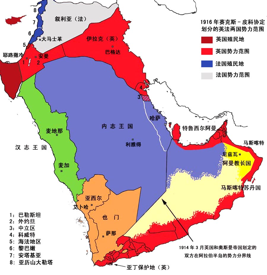
1919年的阿拉伯半島政治地圖 圖例說明 1916年,英國與法國簽訂《賽克斯-皮科協定》,秘密劃分戰後兩國在土耳其所屬的阿拉伯領土上的勢力範圍。《賽克斯-皮科協定》規定巴勒斯坦、外約旦、伊拉克為英國的勢力範圍,其中巴勒斯坦的zh:海法地區和伊拉克的美索布達米亞由英國直接統治;巴勒斯坦以北的地中海東岸為法國直接統治的區域,內陸則為法國勢力範圍。 1919年,英法按照《賽克斯-皮科協定》的精神對兩國在阿拉伯半島北部的勢力範圍進行了劃分。英國獲得對巴勒斯坦、外約旦、伊拉克的委任統治權力,法國獲得對敘利亞、黎巴嫩、安塔基亞和亞歷山大勒塔的委任統治權。 1919年至1925年間,阿拉伯半島的政治邊界進行了多處調整:法國在敘利亞南部建立了自治的zh:德魯茲國家;敘利亞東部盛產石油的zh:摩蘇爾地區歸伊拉克;zh:漢志王國被內志王國佔領後,英國獲得了亞喀巴地區,將其併入外約旦;亞西爾國和也門的北部地區被內志王國吞併;zh:1922年在伊拉克和內志的邊界、以及科威特與內志的邊界上劃定了兩處zh:中立區(科威特與內志之間的中立區在1914年之前即已存在,但沒有法律上的條文作為其存在依據)。 |
| Date | Commons upload by Shizhao 17:49, 25 May 2006 (UTC) |
| Source |
Originally from zh.wikipedia; description page is (was) here |
| Author | User Kallgan on zh.wikipedia |
| Permission (Reusing this file) |
This file is licensed under the Creative Commons Attribution-Share Alike 1.0 Generic license.
|

|
This historical map image could be re-created using vector graphics as an SVG file. This has several advantages; see Commons:Media for cleanup for more information. If an SVG form of this image is available, please upload it and afterwards replace this template with
{{vector version available|new image name}}.
It is recommended to name the SVG file “Arabia1919.svg”—then the template Vector version available (or Vva) does not need the new image name parameter. |


File history
Click on a date/time to view the file as it appeared at that time.
| Date/Time | Thumbnail | Dimensions | User | Comment | |
|---|---|---|---|---|---|
| current | 17:49, 25 May 2006 | | 900 × 925 (127 KB) | Shizhao (talk | contribs) | {{Information| |Description= 1919年的阿拉伯半島政治地圖 圖例說明 1916年,英國與法國簽訂《賽克斯-皮科協定》,秘密劃分戰後兩國在土耳其所屬的阿拉伯領土上的勢力範圍。《賽克斯-皮科協定》� |
You cannot overwrite this file.
File usage on Commons
There are no pages that use this file.
File usage on other wikis
The following other wikis use this file:
- Usage on sh.wikipedia.org
- Usage on zh.wikipedia.org