File:Aquifer en.svg
Jump to navigation
Jump to search

Size of this PNG preview of this SVG file: 606 × 600 pixels. Other resolutions: 243 × 240 pixels | 485 × 480 pixels | 776 × 768 pixels | 1,035 × 1,024 pixels | 2,070 × 2,048 pixels | 672 × 665 pixels.
Original file (SVG file, nominally 672 × 665 pixels, file size: 35 KB)
Captions
Captions
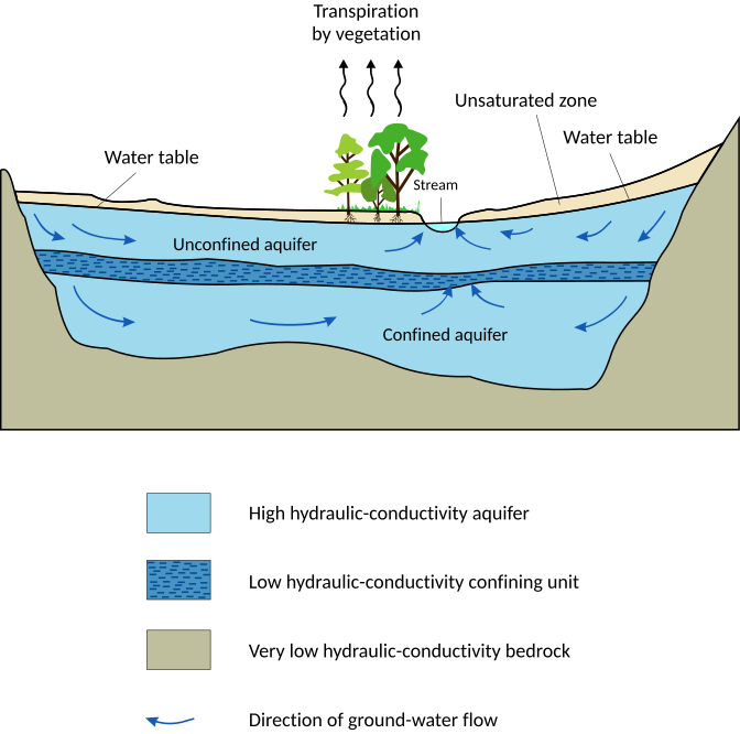
An aquifer cross-section. This diagram shows two aquifers with one aquitard (a confining or impermeable layer) between them, surrounded by the bedrock aquiclude, which is in contact with a gaining stream (typical in humid regions).
| Description |
English: Aquifer (vectorized) |
||||
| Date | |||||
| Source | en:Image:Schematic aquifer xsection usgs cir1186.png | ||||
| Author | Hans Hillewaert | ||||
| Permission (Reusing this file) |
I, the copyright holder of this work, hereby publish it under the following license: This file is licensed under the Creative Commons Attribution-Share Alike 3.0 Unported license.
|
||||
| Other versions |
[]
|
||||
| Other licenses | More (4100+) and new images on : High resolution files on request. . |
||||
| Attribution (required by the license) | © Hans Hillewaert / | ||||
| SVG development | This diagram was created with Adobe Illustrator. This diagram uses embedded text that can be easily translated using a text editor.
|


File history
Click on a date/time to view the file as it appeared at that time.
| Date/Time | Thumbnail | Dimensions | User | Comment | |
|---|---|---|---|---|---|
| current | 22:19, 27 April 2012 | | 672 × 665 (35 KB) | Fred the Oyster (talk | contribs) | Optimise code |
| 07:59, 25 May 2007 |  | 720 × 700 (83 KB) | Lycaon (talk | contribs) | == Summary == {{Information |Description={{en|Aquifer (vectorized)}} |Source=en:Image:Schematic aquifer xsection usgs cir1186.png |Date=22-06-2006 |Author=Hans Hillewaert (Lycaon) |Permission={{self|cc-by-sa-2.5}}{{PD-USGov}} |other_v |
You cannot overwrite this file.
File usage on Commons
The following 30 pages use this file:
- User:Dvdgmz/wikiArS-ref
- User:McCormack/gallery
- User talk:Lycaon/Archive3
- Commons:Featured picture candidates/Image:Aquifer en.svg
- Commons:Featured picture candidates/Log/November 2007
- Commons:Quality images/Subject/Non photographic media
- Commons:Quality images candidates/Archives May 2007
- File:Aquifer-ar.jpg
- File:Aquifer-kn.svg
- File:Aquifer-pa.svg
- File:Aquifer-ta.svg
- File:Aquifer.svg
- File:Aquifer as.svg
- File:Aquifer bn.svg
- File:Aquifer da.svg
- File:Aquifer de.svg
- File:Aquifer en.svg
- File:Aquifer es.svg
- File:Aquifer hi.svg
- File:Aquifer id.svg
- File:Aquifer it.svg
- File:Aquifer ne.svg
- File:Aquifer nv.svg
- File:Aquifer ro.svg
- File:Aquifer te.svg
- File:Aquifer tr.svg
- File:Aquifer uk.svg
- File:SchematicAquiferXsection gl.svg
- File:Schematic aquifer xsection usgs cir1186.png
- Template:Other versions/Aquifer
File usage on other wikis
The following other wikis use this file:
- Usage on an.wikipedia.org
- Usage on bg.wikipedia.org
- Usage on bn.wikipedia.org
- Usage on ca.wikipedia.org
- Usage on cdo.wikipedia.org
- Usage on da.wikipedia.org
- Usage on en.wikipedia.org
- Usage on fa.wikipedia.org
- Usage on fr.wikipedia.org
- Usage on hy.wikipedia.org
- Usage on ka.wikipedia.org
- Usage on kk.wikipedia.org
- Usage on mn.wikipedia.org
- Usage on ms.wikipedia.org
- Usage on no.wikipedia.org
- Usage on outreach.wikimedia.org
- Usage on pl.wiktionary.org
- Usage on simple.wikipedia.org
- Usage on sl.wikipedia.org
- Usage on sr.wikipedia.org
- Usage on su.wikipedia.org
- Usage on sv.wikipedia.org
- Usage on th.wikipedia.org
- Usage on tr.wikipedia.org
- Usage on war.wikipedia.org
- Usage on www.wikidata.org
- Usage on zh.wikipedia.org