File:AquaMap Submersible LBL Acoustic Positioning Equipment.jpg
Jump to navigation
Jump to search

Size of this preview: 450 × 600 pixels. Other resolutions: 180 × 240 pixels | 360 × 480 pixels | 576 × 768 pixels | 1,200 × 1,600 pixels.
Original file (1,200 × 1,600 pixels, file size: 949 KB, MIME type: image/jpeg)
Captions
Captions
Add a one-line explanation of what this file represents
Summary[edit]
| Description |
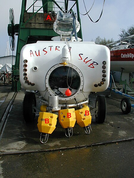
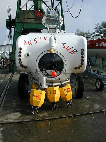
English: The three-person manned submersible 'Austria Sub' equipped with its AquaMap long-baseline (LBL) acoustic positioning system. The baseline transponders (B) which serve as the reference points for navigation will be deployed on the seafloor, and then location surveyed using a combination of acoustic self-surveying techniques and GPS before underwater operations proceed. During a diver, the submarine transponder with its associated sonar transducer (A) will emit pings that are received by the baseline stations, which then reply. Thus, the distance to each station is determined and the submarine position can be computed with sub-meter accuracy. |
| Date | |
| Source | Own work |
| Author | Desertstar |
| Permission (Reusing this file) |
Desert Star permission |
Licensing[edit]
I, the copyright holder of this work, hereby publish it under the following license:
This file is licensed under the Creative Commons Attribution 3.0 Unported license.
- You are free:
- to share – to copy, distribute and transmit the work
- to remix – to adapt the work
- Under the following conditions:
- attribution – You must give appropriate credit, provide a link to the license, and indicate if changes were made. You may do so in any reasonable manner, but not in any way that suggests the licensor endorses you or your use.
File history
Click on a date/time to view the file as it appeared at that time.
| Date/Time | Thumbnail | Dimensions | User | Comment | |
|---|---|---|---|---|---|
| current | 21:08, 17 May 2009 | | 1,200 × 1,600 (949 KB) | Desertstar (talk | contribs) | {{Information |Description={{en|1=The three-person manned submersible 'Austria Sub' equipped with its AquaMap long-baseline (LBL) acoustic positioning system. The baseline transponders (B) which serve as the reference points for navigation will be deploy |
You cannot overwrite this file.
File usage on Commons
There are no pages that use this file.
File usage on other wikis
The following other wikis use this file:
- Usage on en.wikipedia.org