File:Approximate extension of Alodia based on accounts of Ibn Hawqal.png
Jump to navigation
Jump to search

Size of this preview: 800 × 581 pixels. Other resolutions: 320 × 232 pixels | 640 × 464 pixels | 813 × 590 pixels.
Original file (813 × 590 pixels, file size: 106 KB, MIME type: image/png)
Captions
Captions
Add a one-line explanation of what this file represents
Summary
[edit]
| Description |
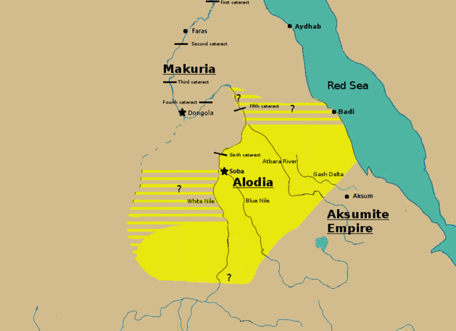
English: Initially based on map IX from the book "The Kingdom of Alwa" (see the first four versions of the map to see the faithful copy).[1] The original map had several problems, so I decided to modify it. 1) Zarroug had Alodia extend as far west as Darfur. However, there is still virtually no archaeological evidence supporting this assumption.[2] 2) The exact nothern border is still desputed; it is generally placed between Abu Hamad and the confluence of the Nile and the Atbara.[3] 3) Zarroug shows all regions west of the Nile as part of Alodia. However, the traveller Ibn Hawqal explicitly stated that parts of the region west of the White Nile were part of Makuria. The Nuba mountains were probably part of Alodia, hence I included stripes and a question mark for the area between the confluence of the two Niles and the Nuba mountains.[4] 4) There is little evidence that the Bayuda desert (between ed Debba and Omdurman) was part of either Makuria or Alodia.[5]
|
| Date | |
| Source | Own work |
| Author | LeGabrie |
Licensing
[edit]
I, the copyright holder of this work, hereby publish it under the following license:
This file is licensed under the Creative Commons Attribution-Share Alike 4.0 International license.
- You are free:
- to share – to copy, distribute and transmit the work
- to remix – to adapt the work
- Under the following conditions:
- attribution – You must give appropriate credit, provide a link to the license, and indicate if changes were made. You may do so in any reasonable manner, but not in any way that suggests the licensor endorses you or your use.
- share alike – If you remix, transform, or build upon the material, you must distribute your contributions under the same or compatible license as the original.
File history
Click on a date/time to view the file as it appeared at that time.
| Date/Time | Thumbnail | Dimensions | User | Comment | |
|---|---|---|---|---|---|
| current | 15:20, 27 November 2018 | | 813 × 590 (106 KB) | LeGabrie (talk | contribs) | Deleted stripes in Bayuda desert |
| 15:47, 28 October 2018 |  | 703 × 590 (114 KB) | LeGabrie (talk | contribs) | decreased width | |
| 12:51, 15 October 2018 |  | 813 × 590 (108 KB) | LeGabrie (talk | contribs) | Added Gash Delta | |
| 11:38, 29 September 2018 |  | 813 × 590 (108 KB) | LeGabrie (talk | contribs) | Extended the beams over the entire Bayuda | |
| 12:12, 4 September 2018 |  | 813 × 590 (111 KB) | LeGabrie (talk | contribs) | added question mark | |
| 11:59, 4 September 2018 |  | 813 × 590 (108 KB) | LeGabrie (talk | contribs) | Cut the beams in Darfur | |
| 00:55, 1 September 2018 |  | 813 × 590 (114 KB) | LeGabrie (talk | contribs) | Increased script size | |
| 00:51, 1 September 2018 |  | 813 × 590 (114 KB) | LeGabrie (talk | contribs) | small fix | |
| 00:49, 1 September 2018 |  | 813 × 590 (114 KB) | LeGabrie (talk | contribs) | Made it prettier | |
| 21:14, 1 February 2018 |  | 813 × 590 (155 KB) | LeGabrie (talk | contribs) | Added white beams and question marks to highlight the uncertainties of Zarroug's map. These uncertainties are: The extension into Darfur,the question of ownership of northern Kordofan and the beginning of Al-Abwab. The concrete amount of desert aside o... |
You cannot overwrite this file.
File usage on Commons
There are no pages that use this file.
File usage on other wikis
The following other wikis use this file:
- Usage on ar.wikipedia.org
- Usage on arz.wikipedia.org
- Usage on azb.wikipedia.org
- Usage on cs.wikipedia.org
- Usage on de.wikipedia.org
- Usage on en.wikipedia.org
- Usage on es.wikipedia.org
- Usage on fa.wikipedia.org
- Usage on fi.wikipedia.org
- Usage on fr.wikipedia.org
- Usage on id.wikipedia.org
- Usage on ms.wikipedia.org
- Usage on nl.wikipedia.org
- Usage on pt.wikipedia.org
- Usage on ru.wikipedia.org
- Usage on sl.wikipedia.org
- Usage on sr.wikipedia.org
- Usage on sv.wikipedia.org
- Usage on ta.wikipedia.org
- Usage on th.wikipedia.org
- Usage on tl.wikipedia.org
- Usage on uk.wikipedia.org
- Usage on vi.wikipedia.org
- Usage on zh.wikipedia.org