File:AppTrailMap.svg
Jump to navigation
Jump to search

Size of this PNG preview of this SVG file: 126 × 595 pixels. Other resolutions: 50 × 240 pixels | 101 × 480 pixels | 162 × 768 pixels | 216 × 1,024 pixels | 433 × 2,048 pixels | 710 × 3,355 pixels.
Original file (SVG file, nominally 710 × 3,355 pixels, file size: 5.63 MB)
Captions
Captions
Add a one-line explanation of what this file represents
Summary[edit]
| Description |
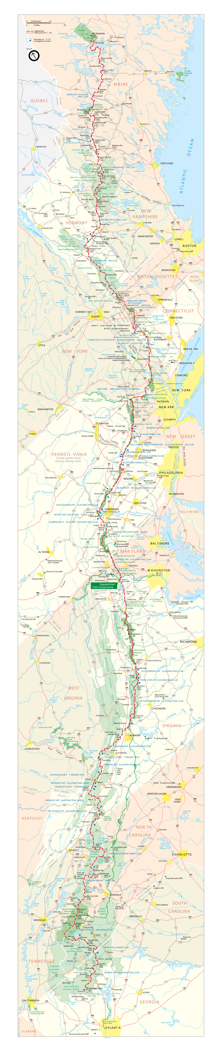
English: Vector map of the Appalachian Trail. English language. |
| Date | Unknown date |
| Source | U.S. National Park Service |
| Author | U.S. National Park Service |
| Permission (Reusing this file) |
PD-USGOV-INTERIOR-NPS; PD-USGOV-NPS. |
| Other versions | File:Appalachian_Trail_Map_copy.png |
PDF version available from NPS website: http://www.nps.gov/appa/planyourvisit/upload/APPA%20Map.pdf
Licensing[edit]
| This image or media file contains material based on a work of a National Park Service employee, created as part of that person's official duties. As a work of the U.S. federal government, such work is in the public domain in the United States. See the NPS website and NPS copyright policy for more information. |
File history
Click on a date/time to view the file as it appeared at that time.
| Date/Time | Thumbnail | Dimensions | User | Comment | |
|---|---|---|---|---|---|
| current | 20:28, 16 March 2011 | 710 × 3,355 (5.63 MB) | Chick Bowen (talk | contribs) | Reverted to version as of 17:17, 21 September 2010--didn't work | |
| 20:27, 16 March 2011 | 710 × 3,355 (7.29 MB) | Chick Bowen (talk | contribs) | larger nominal file size | ||
| 17:17, 21 September 2010 | 710 × 3,355 (5.63 MB) | Cadastral (talk | contribs) | {{Information |Description={{en|1=Vector map of the Appalachian Trail. English language.}} |Source=U.S. National Park Service |Author=U.S. National Park Service |Date=Unk |Permission=PD-USGOV-INTERIOR-NPS; PD-USGOV-NPS. |other_versions=http://commons.wik |
You cannot overwrite this file.
File usage on Commons
The following 2 pages use this file:
File usage on other wikis
The following other wikis use this file:
- Usage on de.wikipedia.org
- Usage on de.wikivoyage.org
- Usage on en.wikipedia.org
- Usage on fr.wikipedia.org
- Usage on hr.wikipedia.org
- Usage on it.wikipedia.org
- Usage on tr.wikipedia.org
- Usage on uk.wikipedia.org
- Usage on www.wikidata.org
- Usage on zh.wikipedia.org