File:AntrimShaleStratigraphicChart.JPG
Jump to navigation
Jump to search
No higher resolution available.
AntrimShaleStratigraphicChart.JPG (366 × 570 pixels, file size: 50 KB, MIME type: image/jpeg)
Captions
Captions
Add a one-line explanation of what this file represents
Summary[edit]
| Description | |
| Date | |
| Source | http://pubs.usgs.gov/of/1996/of96-023/ USGS Open-File Report 96-23 |
| Author | Robert T. Ryder |
| Permission (Reusing this file) |
US federal government |
Licensing[edit]
This image is in the public domain in the United States because it only contains materials that originally came from the United States Geological Survey, an agency of the United States Department of the Interior. For more information, see the official USGS copyright policy.
|
File history
Click on a date/time to view the file as it appeared at that time.
| Date/Time | Thumbnail | Dimensions | User | Comment | |
|---|---|---|---|---|---|
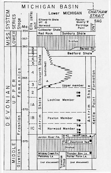
| current | 02:33, 4 November 2009 | | 366 × 570 (50 KB) | Plazak (talk | contribs) | {{Information |Description = Chart showing stratigraphic position of the Antrim Shale in the Michigan Basin, USA. |Source = USGS Open-File Report 96-23 |Date = 1996 |Author = Robert T. Ryder |Permission = US f |
You cannot overwrite this file.
File usage on Commons
There are no pages that use this file.
File usage on other wikis
The following other wikis use this file:
- Usage on en.wikipedia.org