File:Antarctica regions map.svg
Jump to navigation
Jump to search

Size of this PNG preview of this SVG file: 719 × 600 pixels. Other resolutions: 288 × 240 pixels | 575 × 480 pixels | 921 × 768 pixels | 1,228 × 1,024 pixels | 2,455 × 2,048 pixels | 1,671 × 1,394 pixels.
Original file (SVG file, nominally 1,671 × 1,394 pixels, file size: 1.9 MB)
Captions
Captions
Add a one-line explanation of what this file represents
Summary[edit]
| Description |
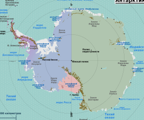
English: Antarctica regions map. Major features labeled, but smaller ones & research stations left for maps of subregions (each dot on map is a research station), Antarctica. |
| Date | |
| Source | Several PD sources, like this, this, and this |
| Author | Peter Fitzgerald |
| Other versions |
.png)
Licensing[edit]
This file is licensed under the Creative Commons Attribution 3.0 Unported license.
- You are free:
- to share – to copy, distribute and transmit the work
- to remix – to adapt the work
- Under the following conditions:
- attribution – You must give appropriate credit, provide a link to the license, and indicate if changes were made. You may do so in any reasonable manner, but not in any way that suggests the licensor endorses you or your use.
Original upload log[edit]
| This file was imported from Wikivoyage WTS. |
The original description page was here. All following user names refer to wts.wikivoyage-old.
- 2008-08-06 08:45 (WT-shared) Peterfitzgerald archive copy at the Wayback Machine 1671×1394 (1867776 bytes) {{Imagecredit|credit=Peter Fitzgerald|captureDate=6 August 2008|location=Antarctica|source=Several PD sources, like [[:commons:Image:Antarct (Import from wikitravel.org/shared)
- 2008-08-07 04:20 (WT-shared) Peterfitzgerald archive copy at the Wayback Machine 1671×1394 (1989307 bytes) corrections, +ru version (Import from wikitravel.org/shared)
- 2008-08-07 10:57 (WT-shared) Peterfitzgerald archive copy at the Wayback Machine 1671×1394 (1989349 bytes) corrections to Russian version (Import from wikitravel.org/shared)
- 2008-08-07 11:00 (WT-shared) Peterfitzgerald archive copy at the Wayback Machine 1671×1394 (1989343 bytes) missed 1 (Import from wikitravel.org/shared)
- 2008-08-09 03:57 (WT-shared) Peterfitzgerald archive copy at the Wayback Machine 1671×1394 (1989345 bytes) small change to ru version (Import from wikitravel.org/shared)
File history
Click on a date/time to view the file as it appeared at that time.
| Date/Time | Thumbnail | Dimensions | User | Comment | |
|---|---|---|---|---|---|
| current | 03:58, 21 November 2012 | | 1,671 × 1,394 (1.9 MB) | OgreBot (talk | contribs) | (BOT): Reverting to most recent version before archival |
| 03:58, 21 November 2012 |  | 1,671 × 1,394 (1.9 MB) | OgreBot (talk | contribs) | (BOT): Uploading old version of file from wts.wikivoyage; originally uploaded on 2008-08-07 11:00:53 by (WT-shared) Peterfitzgerald | |
| 03:58, 21 November 2012 |  | 1,671 × 1,394 (1.9 MB) | OgreBot (talk | contribs) | (BOT): Uploading old version of file from wts.wikivoyage; originally uploaded on 2008-08-07 10:57:17 by (WT-shared) Peterfitzgerald | |
| 03:58, 21 November 2012 |  | 1,671 × 1,394 (1.9 MB) | OgreBot (talk | contribs) | (BOT): Uploading old version of file from wts.wikivoyage; originally uploaded on 2008-08-07 04:20:52 by (WT-shared) Peterfitzgerald | |
| 03:58, 21 November 2012 |  | 1,671 × 1,394 (1.78 MB) | OgreBot (talk | contribs) | (BOT): Uploading old version of file from wts.wikivoyage; originally uploaded on 2008-08-06 08:45:39 by (WT-shared) Peterfitzgerald | |
| 21:22, 17 November 2012 |  | 1,671 × 1,394 (1.9 MB) | MGA73bot2 (talk | contribs) | {{BotMoveToCommons|wts.oldwikivoyage|year={{subst:CURRENTYEAR}}|month={{subst:CURRENTMONTHNAME}}|day={{subst:CURRENTDAY}}}} == {{int:filedesc}} == {{Information |description=Antarctica regions map. Major features labeled, but smaller ones & research st... |
You cannot overwrite this file.
File usage on Commons
The following page uses this file:
File usage on other wikis
The following other wikis use this file:
- Usage on ka.wikipedia.org