File:Antarctic (MODIS 2018-01-05).jpg

Original file (5,544 × 5,009 pixels, file size: 3.73 MB, MIME type: image/jpeg)
Captions
Captions
Summary[edit]
.jpg&action=edit§ion=1)
| Description |
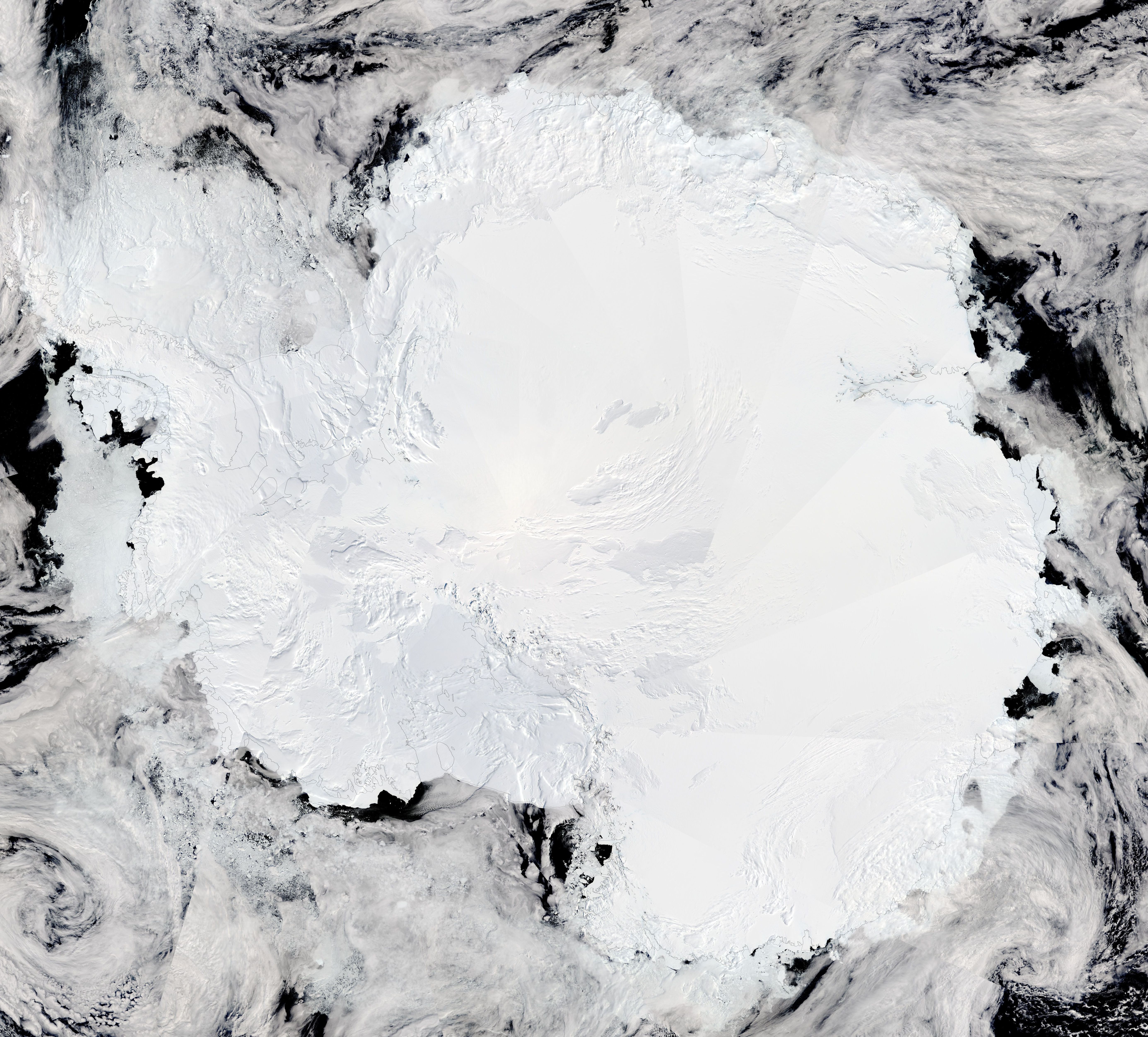
English: On December 28, 2017 the Moderate Resolution Imaging Spectroradiometer (MODIS) on board NASA’s Aqua satellite acquired a true-color image of the Antarctic. The ice-covered continent of Antarctica sits underneath an uneven layer of thick cloud and is surrounded by sea ice.
Antarctica is the highest, driest, coldest, windiest and brightest of the seven continents. It is roughly the size of the United States and Mexico combined and is almost completely covered by a layer of ice that averages more than one mile in thickness, but is nearly three miles thick in places. This ice accumulated over millions of years through snowfall. Presently, the Antarctic ice sheet contains 90% of the ice on Earth and would raise sea levels worldwide by over 200 feet were it to melt. NASA Scientists are currently working in Antarctica studying the continent through Operation IceBridge, which is the largest airborne survey of Earth’s polar ice to ever be attempted. Yearly flights over both the Arctic and Antarctic use multiple instruments to look at the behavior of the rapidly changing features of Arctic and Antarctic ice. Operation IceBridge data was designed to help bridge the gap in polar observations between ICESat missions. The first Ice, Cloud, and Land Elevation Satellite (ICESat) was launched in 2003 and stopped collecting data in 2009 while ICESat 2 is planned to launch in 2018. Meanwhile, the dedicated scientists work in frigid conditions to continue to collect data. On December 25, 2017, NASA Scientists spent their Christmas celebration at the South Pole. This year they are making a traverse of Antarctica and began this up-close and personal trip on January 2, 2018. Their blog, detailing their work and their adventures, can be found on NASA’s Earth Observatory website in the Notes from the Field section. A link to the latest entry is here: |
||
| Date | Taken on 28 December 2017 | ||
| Source |
|
||
| Author | Jeff Schmaltz, MODIS Land Rapid Response Team, NASA GSFC |
| This media is a product of the Aqua mission Credit and attribution belongs to the mission team, if not already specified in the "author" row |
Licensing[edit]
.jpg&action=edit§ion=2)
| This file is in the public domain in the United States because it was solely created by NASA. NASA copyright policy states that "NASA material is not protected by copyright unless noted". (See Template:PD-USGov, NASA copyright policy page or JPL Image Use Policy.) | ||
 |
Warnings:
|
File history
Click on a date/time to view the file as it appeared at that time.
| Date/Time | Thumbnail | Dimensions | User | Comment | |
|---|---|---|---|---|---|
| current | 01:59, 17 February 2024 | | 5,544 × 5,009 (3.73 MB) | OptimusPrimeBot (talk | contribs) | #Spacemedia - Upload of http://modis.gsfc.nasa.gov/gallery/images/image01052018_1km.jpg via Commons:Spacemedia |
You cannot overwrite this file.
File usage on Commons
There are no pages that use this file.
.jpg&oldid=852696235)