File:Ansiedlungsrayon.svg
Jump to navigation
Jump to search

Size of this PNG preview of this SVG file: 684 × 600 pixels. Other resolutions: 274 × 240 pixels | 547 × 480 pixels | 876 × 768 pixels | 1,168 × 1,024 pixels | 2,336 × 2,048 pixels | 780 × 684 pixels.
Original file (SVG file, nominally 780 × 684 pixels, file size: 474 KB)
Captions
Captions
Add a one-line explanation of what this file represents
Summary[edit]
| Description |
العربية: الإقليم الملّي المُخصص لسُكنى اليهود في روسيا القيصريَّة. تُظهر هذه الخارطة نسبة اليهود المُقيمين بِهذا الإقليم حوالي سنة 1905م.
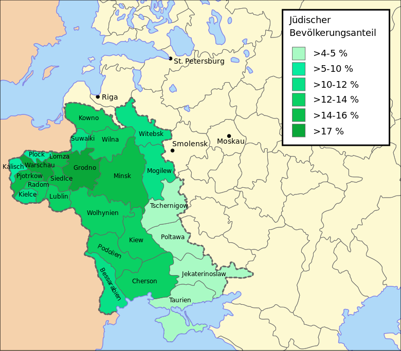
Deutsch: Der "Ansiedlungsrayon" mit "Kongresspolen" im zaristischen Russland mit dem Prozentsatz an jüdischer Bevölkerung in der einzelnen Gouvernements (1905).
English: The "Pale of Settlement" with "Congress Poland" in Tsarist Russia with percentages of Jewish population in the governorates, 1905.
עברית: עברית: חלוקה מנהלית של מערב רוסיה, כולל אחוזי האוכלוסיה היהודית בגוברניות, וסימון סניפי "עם עולם" |
| Date | |
| Source |
|
| Author | Furfur |
| Permission (Reusing this file) |
I, the copyright holder of this work, hereby publish it under the following license: This file is licensed under the Creative Commons Attribution-Share Alike 4.0 International license.
|
| Other versions |
|
| SVG development | This vector image was created with Adobe Illustrator. |


.jpg)
File history
Click on a date/time to view the file as it appeared at that time.
| Date/Time | Thumbnail | Dimensions | User | Comment | |
|---|---|---|---|---|---|
| current | 11:15, 14 June 2015 | | 780 × 684 (474 KB) | Furfur (talk | contribs) | ein letztes Detail ... |
| 08:14, 14 June 2015 |  | 778 × 683 (475 KB) | Furfur (talk | contribs) | Bildgrenzen | |
| 08:04, 14 June 2015 |  | 868 × 683 (474 KB) | Furfur (talk | contribs) | Grün angepasst | |
| 00:00, 14 June 2015 |  | 868 × 683 (469 KB) | Furfur (talk | contribs) | Bildbegrenzungen | |
| 23:54, 13 June 2015 |  | 1,013 × 684 (469 KB) | Furfur (talk | contribs) | Details | |
| 23:49, 13 June 2015 |  | 1,013 × 684 (469 KB) | Furfur (talk | contribs) | =={{int:filedesc}}== {{Information |Description={{de|1=Der "Ansiedlungsrayon" im zaristischen Russland mit dem Prozentsatz an jüdischer Bevölkerung in der einzelnen Gouvernements.}} |Source= *[[:File:Grodno_province_on_the_map_of_the_western_part_of_... |
You cannot overwrite this file.
File usage on Commons
The following 3 pages use this file:
File usage on other wikis
The following other wikis use this file:
- Usage on als.wikipedia.org
- Usage on ca.wikipedia.org
- Usage on de.wikipedia.org
- Usage on eo.wikipedia.org
- Usage on no.wikipedia.org