File:Annual Arctic Sea Ice Minimum.jpg
Jump to navigation
Jump to search

Size of this preview: 800 × 450 pixels. Other resolutions: 320 × 180 pixels | 640 × 360 pixels | 1,024 × 576 pixels | 1,280 × 720 pixels | 2,560 × 1,440 pixels | 3,840 × 2,160 pixels.
Original file (3,840 × 2,160 pixels, file size: 539 KB, MIME type: image/jpeg)
Captions
Captions
Add a one-line explanation of what this file represents
Summary[edit]
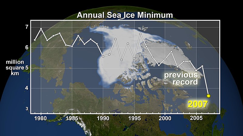
| Description | September ice extent from 1979 to 2007 shows an obvious decline. At the end of each summer, the sea ice cover reaches its minimum extent and the ice that remains is called the perennial ice cover, which consists mainly of thick multi-year ice floes. The area of the perennial ice has been steadily decreasing since the satellite record began in 1979, at a rate of about 10% per decade. But the 2007 minimum, reached around Sept. 14, is far below the previous record made in 2005 and is about 38% lower than the climatological average. This data visualization shows the annual sea ice minimum from 1979 through 2007. |
| Date | 09.25.07 |
| Source | http://www.nasa.gov/vision/earth/environment/arctic_minimum.html |
| Author | NASA |
Licensing[edit]
| This file is in the public domain in the United States because it was solely created by NASA. NASA copyright policy states that "NASA material is not protected by copyright unless noted". (See Template:PD-USGov, NASA copyright policy page or JPL Image Use Policy.) | ||
 |
Warnings:
|
File history
Click on a date/time to view the file as it appeared at that time.
| Date/Time | Thumbnail | Dimensions | User | Comment | |
|---|---|---|---|---|---|
| current | 05:42, 20 June 2008 | | 3,840 × 2,160 (539 KB) | Sagredo (talk | contribs) | {{Information |Description={{en|1=|Description=September ice extent from 1979 to 2007 shows an obvious decline. At the end of each summer, the sea ice cover reaches its minimum extent and the ice that remains is called the perennial ice cover, which consi |
You cannot overwrite this file.
File usage on Commons
There are no pages that use this file.
File usage on other wikis
The following other wikis use this file:
- Usage on en.wikipedia.org