File:Andijan districts numbered.png
Jump to navigation
Jump to search

Size of this preview: 776 × 600 pixels. Other resolutions: 311 × 240 pixels | 621 × 480 pixels | 994 × 768 pixels | 1,280 × 989 pixels | 2,112 × 1,632 pixels.
Original file (2,112 × 1,632 pixels, file size: 51 KB, MIME type: image/png)
Captions
Captions
Add a one-line explanation of what this file represents
| Description |
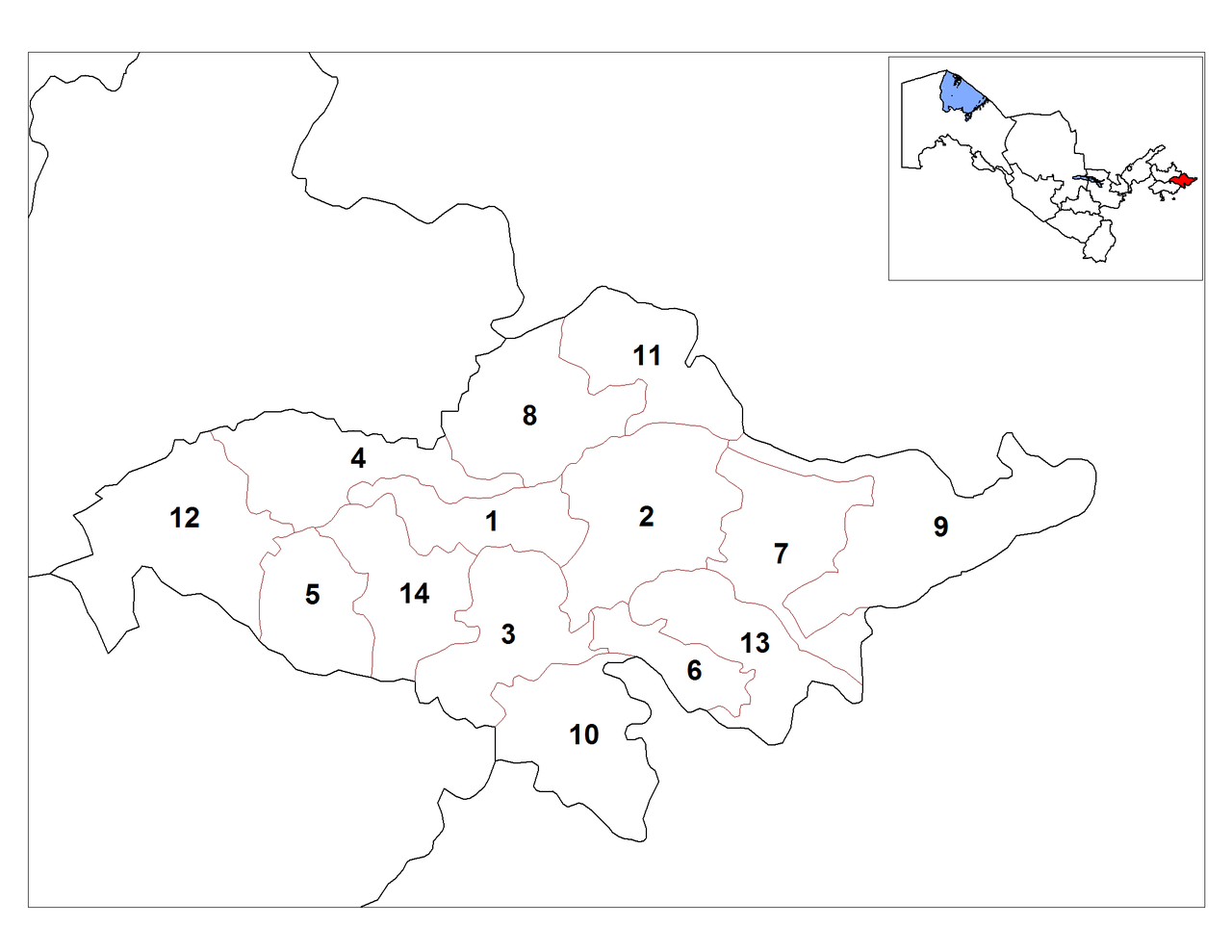
English: Map of the districts (tumans) of the province (viloyat) of Andijan in Uzbekistan. Українська: Карта районів Андижанської області Узбекистану: 1. Альтинкульський, 2. Андижанський, 3. Асакинський, 4. Баликчинський, 5. Бозький, 6. Булакбашинський, 7. Джалалкудукський, 8. Ізбасканський, 9. Кургантепинський, 10. Мархаматський, 11. Пахтаабадський, 12. Улугнорський, 13. Ходжаабадський, 14. Шахріханський |
| Date | |
| Source | Andijan_districts.png |
| Author |
|
| This is a retouched picture, which means that it has been digitally altered from its original version. Modifications: change numbers. The original can be viewed here: Andijan districts.png:
|
This file is licensed under the Creative Commons Attribution-Share Alike Attribution-Share Alike 4.0 International, 3.0 Unported, 2.5 Generic, 2.0 Generic and 1.0 Generic license.
- You are free:
- to share – to copy, distribute and transmit the work
- to remix – to adapt the work
- Under the following conditions:
- attribution – You must give appropriate credit, provide a link to the license, and indicate if changes were made. You may do so in any reasonable manner, but not in any way that suggests the licensor endorses you or your use.
- share alike – If you remix, transform, or build upon the material, you must distribute your contributions under the same or compatible license as the original.

|
This locator map image could be re-created using vector graphics as an SVG file. This has several advantages; see Commons:Media for cleanup for more information. If an SVG form of this image is available, please upload it and afterwards replace this template with
{{vector version available|new image name}}.
It is recommended to name the SVG file “Andijan districts numbered.svg”—then the template Vector version available (or Vva) does not need the new image name parameter. |
Original upload log[edit]
This image is a derivative work of the following images:
- File:Andijan_districts.png licensed with PD-self
- 2008-10-28T14:51:07Z Man77 2112x1632 (50559 Bytes) == Summary == {{Information |Description={{en|1=Map of the districts (tuman) of the province (viloyat) of Andijan in Uzbekistan.}} |Source=Own work by uploader |Author=[[User:Rarelibra|Rarelibra]] |Date=10/20/2008 |Permission
- 2008-10-20T17:53:11Z Rarelibra 2112x1632 (52645 Bytes) {{Information |Description={{en|1=Map of the districts (tuman) of the province (viloyat) of Andijan in Uzbekistan.}} |Source=Own work by uploader |Author=[[User:Rarelibra|Rarelibra]] |Date=10/20/2008 |Permission= |other_versi
File history
Click on a date/time to view the file as it appeared at that time.
| Date/Time | Thumbnail | Dimensions | User | Comment | |
|---|---|---|---|---|---|
| current | 12:00, 27 January 2009 | | 2,112 × 1,632 (51 KB) | Ahonc (talk | contribs) | {{Information |Description= |Source= |Date= |Author= |Permission= |other_versions= }} |
| 23:13, 26 January 2009 |  | 2,112 × 1,632 (102 KB) | Ahonc (talk | contribs) | {{Information |Description={{en|1=Map of the districts (tumans) of the province (viloyat) of Andijan in Uzbekistan.}} {{uk|Карта районів Андижанської області Узбекистану:<br> 1. Альтинкульський, 2. |
You cannot overwrite this file.
File usage on Commons
There are no pages that use this file.
File usage on other wikis
The following other wikis use this file:
- Usage on be-tarask.wikipedia.org
- Usage on kk.wikipedia.org
- Usage on ru.wikipedia.org
- Usage on uk.wikipedia.org
- Usage on uz.wikipedia.org