File:Ancient Egypt map-ru.svg
Jump to navigation
Jump to search

Size of this PNG preview of this SVG file: 293 × 598 pixels. Other resolutions: 117 × 240 pixels | 235 × 480 pixels | 376 × 768 pixels | 501 × 1,024 pixels | 1,003 × 2,048 pixels | 1,577 × 3,219 pixels.
Original file (SVG file, nominally 1,577 × 3,219 pixels, file size: 410 KB)
Captions
Captions
Add a one-line explanation of what this file represents
This W3C-unspecified vector image was created with Inkscape .
Summary[edit]
| Description |
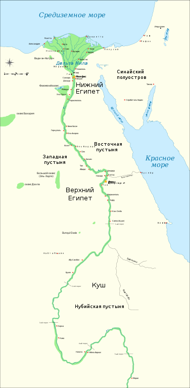
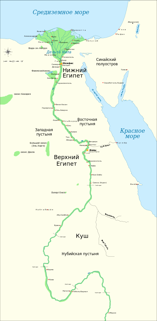
Русский: Карта Древнего Египта. Показаны крупнейшие города и места раскопок Династического периода (с 3150 г. до н.э по 30 г. до н.э.), Нил до 5-го порога. Для справки показано местоположение Каира и Иерусалима.
English: Map of Ancient Egypt, showing the Nile up to the fifth cataract, and major cities and sites of the Dynastic period (c. 3150 BC to 30 BC). Cairo and Jerusalem are shown as reference cities. |
| Date | |
| Source | Russian translation of Ancient_Egypt_map-en.svg |
| Author |
|
| Other versions |
[]
|


|
This SVG file contains embedded text that can be translated into your language, using any capable SVG editor, text editor or the SVG Translate tool. For more information see: About translating SVG files. |
| This is a retouched picture, which means that it has been digitally altered from its original version. Modifications: translation to Russian. The original can be viewed here: Ancient Egypt map-en.svg:
|
Licensing[edit]
I, the copyright holder of this work, hereby publish it under the following licenses:
This file is licensed under the Creative Commons Attribution-Share Alike 3.0 Unported, 2.5 Generic, 2.0 Generic and 1.0 Generic license.
- You are free:
- to share – to copy, distribute and transmit the work
- to remix – to adapt the work
- Under the following conditions:
- attribution – You must give appropriate credit, provide a link to the license, and indicate if changes were made. You may do so in any reasonable manner, but not in any way that suggests the licensor endorses you or your use.
- share alike – If you remix, transform, or build upon the material, you must distribute your contributions under the same or compatible license as the original.

|
Permission is granted to copy, distribute and/or modify this document under the terms of the GNU Free Documentation License, Version 1.2 or any later version published by the Free Software Foundation; with no Invariant Sections, no Front-Cover Texts, and no Back-Cover Texts. A copy of the license is included in the section entitled GNU Free Documentation License. |
You may select the license of your choice.
File history
Click on a date/time to view the file as it appeared at that time.
| Date/Time | Thumbnail | Dimensions | User | Comment | |
|---|---|---|---|---|---|
| current | 18:30, 25 June 2009 | | 1,577 × 3,219 (410 KB) | Anton Gutsunaev~commonswiki (talk | contribs) | fix |
| 18:20, 25 June 2009 |  | 1,577 × 3,219 (411 KB) | Anton Gutsunaev~commonswiki (talk | contribs) | {{Information |Description={{ru|Карта Древнего Египта. Показаны крупнейшие города и места раскопок Династического периода (с 3150 г. до н.э по 30 г. до н.э.), Ни� |
You cannot overwrite this file.
File usage on Commons
The following 27 pages use this file:
- File:Ancient Egypt map-af.svg
- File:Ancient Egypt map-ar.png
- File:Ancient Egypt map-de.svg
- File:Ancient Egypt map-el.svg
- File:Ancient Egypt map-en.svg
- File:Ancient Egypt map-es.svg
- File:Ancient Egypt map-fr.svg
- File:Ancient Egypt map-hiero.svg
- File:Ancient Egypt map-it.svg
- File:Ancient Egypt map-la.png
- File:Ancient Egypt map-la.svg
- File:Ancient Egypt map-mk.svg
- File:Ancient Egypt map-nl.svg
- File:Ancient Egypt map-no.svg
- File:Ancient Egypt map-pl.svg
- File:Ancient Egypt map-pt.svg
- File:Ancient Egypt map-ru.svg
- File:Ancient Egypt map-sk.svg
- File:Ancient Egypt map-sr.svg
- File:Ancient Egypt map-vi.svg
- File:Ancient Egypt map-zh-hans.svg
- File:Antik Mısır haritası.png
- File:Antzinako Egipto.svg
- File:Mapo de antikva Egiptio.jpg
- File:Mapo de antikva Egiptio - centro.jpg
- File:Muistne Egiptus.png
- Template:Other versions/Ancient Egypt map
File usage on other wikis
The following other wikis use this file:
- Usage on be.wikipedia.org
- Usage on ru.wikipedia.org