File:Ancient Egypt map-fr.svg
Jump to navigation
Jump to search

Size of this PNG preview of this SVG file: 293 × 598 pixels. Other resolutions: 117 × 240 pixels | 235 × 480 pixels | 376 × 768 pixels | 501 × 1,024 pixels | 1,003 × 2,048 pixels | 1,577 × 3,219 pixels.
Original file (SVG file, nominally 1,577 × 3,219 pixels, file size: 417 KB)
Captions
Captions
Add a one-line explanation of what this file represents
Summary[edit]
This W3C-unspecified vector image was created with Inkscape .
| Description |
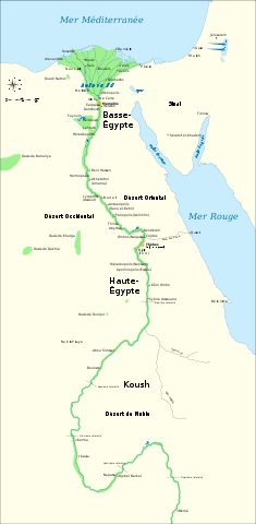
Français : Carte de l'Egypte antique, montrant le Nil jusqu'à la cinquième cataracte et les principaux sites de la période dynastique (v. 3150-30 av. J.-C.). Le Caire et Jérusalem sont représentées comme villes de référence. |
| Date | (original en anglais); 2009-02-20 (traduction française) |
| Source | Traduction de File:Ancient Egypt map-en.svg |
| Author | Jeff Dahl (original en anglais); Bibi Saint-Pol (traduction française) |
| Other versions |
[]
|


|
This SVG file contains embedded text that can be translated into your language, using any capable SVG editor, text editor or the SVG Translate tool. For more information see: About translating SVG files. |
Licensing[edit]
I, the copyright holder of this work, hereby publish it under the following licenses:

|
Permission is granted to copy, distribute and/or modify this document under the terms of the GNU Free Documentation License, Version 1.2 or any later version published by the Free Software Foundation; with no Invariant Sections, no Front-Cover Texts, and no Back-Cover Texts. A copy of the license is included in the section entitled GNU Free Documentation License. |
This file is licensed under the Creative Commons Attribution-Share Alike 4.0 International, 3.0 Unported, 2.5 Generic, 2.0 Generic and 1.0 Generic license.
- You are free:
- to share – to copy, distribute and transmit the work
- to remix – to adapt the work
- Under the following conditions:
- attribution – You must give appropriate credit, provide a link to the license, and indicate if changes were made. You may do so in any reasonable manner, but not in any way that suggests the licensor endorses you or your use.
- share alike – If you remix, transform, or build upon the material, you must distribute your contributions under the same or compatible license as the original.
You may select the license of your choice.
File history
Click on a date/time to view the file as it appeared at that time.
| Date/Time | Thumbnail | Dimensions | User | Comment | |
|---|---|---|---|---|---|
| current | 11:44, 15 May 2011 | | 1,577 × 3,219 (417 KB) | Bibi Saint-Pol (talk | contribs) | fix typo |
| 13:36, 20 February 2009 |  | 1,577 × 3,219 (414 KB) | Bibi Saint-Pol (talk | contribs) | == {{int:filedesc}} == {{inkscape}} {{Information |Description= {{fr|Carte de l'Egypte antique, montrant le Nil jusqu'à la cinquième cataracte et les principaux sites de la période dynastique (v. 3150-30 av. J.-C.). Le Caire et Jérusalem sont représe |
You cannot overwrite this file.
File usage on Commons
The following 27 pages use this file:
- File:Ancient Egypt map-af.svg
- File:Ancient Egypt map-ar.png
- File:Ancient Egypt map-de.svg
- File:Ancient Egypt map-el.svg
- File:Ancient Egypt map-en.svg
- File:Ancient Egypt map-es.svg
- File:Ancient Egypt map-fr.svg
- File:Ancient Egypt map-hiero.svg
- File:Ancient Egypt map-it.svg
- File:Ancient Egypt map-la.png
- File:Ancient Egypt map-la.svg
- File:Ancient Egypt map-mk.svg
- File:Ancient Egypt map-nl.svg
- File:Ancient Egypt map-no.svg
- File:Ancient Egypt map-pl.svg
- File:Ancient Egypt map-pt.svg
- File:Ancient Egypt map-ru.svg
- File:Ancient Egypt map-sk.svg
- File:Ancient Egypt map-sr.svg
- File:Ancient Egypt map-vi.svg
- File:Ancient Egypt map-zh-hans.svg
- File:Antik Mısır haritası.png
- File:Antzinako Egipto.svg
- File:Mapo de antikva Egiptio.jpg
- File:Mapo de antikva Egiptio - centro.jpg
- File:Muistne Egiptus.png
- Template:Other versions/Ancient Egypt map
File usage on other wikis
The following other wikis use this file:
- Usage on fr.wikipedia.org
- Antiquité
- Memphis (Égypte)
- Symbolique des couleurs dans l'Égypte antique
- Basse-Égypte
- Haute-Égypte
- Géographie de l'Égypte antique
- Première Période intermédiaire
- Culture de Nagada
- Égypte antique
- Campagnes d'Auguste en Afrique et en Arabie
- Legio II Traiana Fortis
- Mythes royaux de légitimation dans l'Égypte antique
- Usage on fr.wikiversity.org
- Usage on fr.wiktionary.org
- Usage on ht.wikipedia.org
- Usage on mg.wikipedia.org
- Usage on oc.wikipedia.org