File:Ancient Egypt map-el.png
Jump to navigation
Jump to search

Size of this preview: 293 × 598 pixels. Other resolutions: 117 × 240 pixels | 235 × 480 pixels | 376 × 768 pixels | 1,100 × 2,245 pixels.
Original file (1,100 × 2,245 pixels, file size: 374 KB, MIME type: image/png)
Captions
Captions
Add a one-line explanation of what this file represents
| Description |
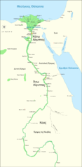
Ελληνικά: Χάρτης της Αρχαίας, Αιγύπτου, που απεικονίζει τον Νείλο έως και τον πέμπτο καταρράκτη, και κύριες πόλεις και τοποθεσίες της Δυναστική περιόδου (περ. 3150 π.Χ. έως 30 π.Χ.). Το Κάιρο και η Ιερουσαλήμ εμφανίζονται ως πόλεις αναφοράς.
English: Map of Ancient Egypt, showing the Nile up to the fifth cataract, and major cities and sites of the Dynastic period (c. 3150 BC to 30 BC). Cairo and Jerusalem are shown as reference cities. |
| Date | (UTC) |
| Source | |
| Author | |
| Other versions |
| This is a retouched picture, which means that it has been digitally altered from its original version. Modifications: Translated to Greek. The original can be viewed here: Ancient Egypt map-en.svg:
|
I, the copyright holder of this work, hereby publish it under the following licenses:
This file is licensed under the Creative Commons Attribution-Share Alike 3.0 Unported, 2.5 Generic, 2.0 Generic and 1.0 Generic license.
- You are free:
- to share – to copy, distribute and transmit the work
- to remix – to adapt the work
- Under the following conditions:
- attribution – You must give appropriate credit, provide a link to the license, and indicate if changes were made. You may do so in any reasonable manner, but not in any way that suggests the licensor endorses you or your use.
- share alike – If you remix, transform, or build upon the material, you must distribute your contributions under the same or compatible license as the original.

|
Permission is granted to copy, distribute and/or modify this document under the terms of the GNU Free Documentation License, Version 1.2 or any later version published by the Free Software Foundation; with no Invariant Sections, no Front-Cover Texts, and no Back-Cover Texts. A copy of the license is included in the section entitled GNU Free Documentation License. |
You may select the license of your choice.
File history
Click on a date/time to view the file as it appeared at that time.
| Date/Time | Thumbnail | Dimensions | User | Comment | |
|---|---|---|---|---|---|
| current | 20:33, 19 April 2009 | | 1,100 × 2,245 (374 KB) | Geraki (talk | contribs) | correction of size |
| 20:30, 19 April 2009 |  | 1,000 × 2,286 (289 KB) | Geraki (talk | contribs) | {{Information |Description={{el|Χάρτης της Αρχαίας, Αιγύπτου, που απεικονίζει τον Νείλο έως και τον πέμπτο καταρράκτη, και κύριες πόλεις και τοποθεσίες τη |
You cannot overwrite this file.
File usage on Commons
There are no pages that use this file.
File usage on other wikis
The following other wikis use this file:
- Usage on el.wikipedia.org
- Usage on uk.wikipedia.org