File:Ancient Egypt map-ar.png
Jump to navigation
Jump to search

Size of this preview: 293 × 598 pixels. Other resolutions: 117 × 240 pixels | 235 × 480 pixels | 376 × 768 pixels | 501 × 1,024 pixels | 1,577 × 3,219 pixels.
Original file (1,577 × 3,219 pixels, file size: 281 KB, MIME type: image/png)
Captions
Captions
Add a one-line explanation of what this file represents
Summary[edit]
| Description |
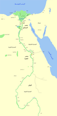
العربية: خريطة لمصر القديمة، حيث يظهر نهر النيل، والمدن الرئيسية ومواقع الفترة (من حوالي 3150 ق.م إلى 30 ق.م). كما تظهر بالخريطة أيضا القاهرة والقدس كمدن مرجعية |
| Date | |
| Source | Ancient Egypt map-en.svg |
| Author |
Ancient Egypt map-en.svg : Jeff Dahl
|
| Permission (Reusing this file) |
Released under the GNU Free Documentation License. |
| Other versions |
[]
|


Licensing[edit]
I, the copyright holder of this work, hereby publish it under the following license:

|
Permission is granted to copy, distribute and/or modify this document under the terms of the GNU Free Documentation License, Version 1.2 or any later version published by the Free Software Foundation; with no Invariant Sections, no Front-Cover Texts, and no Back-Cover Texts. A copy of the license is included in the section entitled GNU Free Documentation License. |
| This file is licensed under the Creative Commons Attribution-Share Alike 3.0 Unported license. | ||
| ||
| This licensing tag was added to this file as part of the GFDL licensing update. |
File history
Click on a date/time to view the file as it appeared at that time.
| Date/Time | Thumbnail | Dimensions | User | Comment | |
|---|---|---|---|---|---|
| current | 22:52, 16 January 2014 | | 1,577 × 3,219 (281 KB) | Freedom's Falcon (talk | contribs) | Correcting in 2 other sites. |
| 22:05, 16 January 2014 |  | 1,577 × 3,219 (280 KB) | Freedom's Falcon (talk | contribs) | Correcting in 4 sites. | |
| 21:53, 16 January 2014 |  | 1,577 × 3,219 (279 KB) | Freedom's Falcon (talk | contribs) | User created page with UploadWizard |
You cannot overwrite this file.
File usage on Commons
The following 28 pages use this file:
- File:Ancient Egypt map-af.svg
- File:Ancient Egypt map-ar.png
- File:Ancient Egypt map-de.svg
- File:Ancient Egypt map-el.svg
- File:Ancient Egypt map-en.svg
- File:Ancient Egypt map-es.svg
- File:Ancient Egypt map-fr.svg
- File:Ancient Egypt map-hiero.svg
- File:Ancient Egypt map-it.svg
- File:Ancient Egypt map-la.png
- File:Ancient Egypt map-la.svg
- File:Ancient Egypt map-mk.svg
- File:Ancient Egypt map-nl.svg
- File:Ancient Egypt map-no.svg
- File:Ancient Egypt map-pl.svg
- File:Ancient Egypt map-pt.svg
- File:Ancient Egypt map-ru.svg
- File:Ancient Egypt map-sk.svg
- File:Ancient Egypt map-sr.svg
- File:Ancient Egypt map-vi.svg
- File:Ancient Egypt map-zh-hans.svg
- File:Ancient Egypt map ar.png (file redirect)
- File:Antik Mısır haritası.png
- File:Antzinako Egipto.svg
- File:Mapo de antikva Egiptio.jpg
- File:Mapo de antikva Egiptio - centro.jpg
- File:Muistne Egiptus.png
- Template:Other versions/Ancient Egypt map
File usage on other wikis
The following other wikis use this file:
- Usage on ar.wikipedia.org
- Usage on ar.wikibooks.org
- Usage on arz.wikipedia.org