File:American Bottom in far southern Monroe County.jpg
Jump to navigation
Jump to search

Size of this preview: 800 × 450 pixels. Other resolutions: 320 × 180 pixels | 640 × 360 pixels | 1,024 × 576 pixels | 1,280 × 720 pixels | 2,816 × 1,584 pixels.
Original file (2,816 × 1,584 pixels, file size: 1.78 MB, MIME type: image/jpeg)
Captions
Captions
Add a one-line explanation of what this file represents
|
This is an image of a place or building that is listed on the National Register of Historic Places in the United States of America. Its reference number is 74000772. |
| Camera location | | View this and other nearby images on: OpenStreetMap |
|---|
| Description |
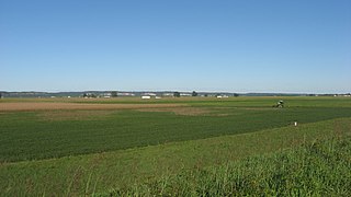
English: Overview of the western end of the French Colonial Historic District, located in the American Bottom west of Fort de Chartres in the southern extreme of Precinct 13, Monroe County, Illinois, United States. The district comprises roads, archaeological sites, and other features associated with Fort de Chartres and related early French settlement in the region; it is listed on the National Register of Historic Places. Picture is taken from the road atop the Mississippi River levee, just east of Ragtown Road. |
||
| Date | Taken on 8 September 2012 | ||
| Source | Own work | ||
| Author | Nyttend | ||
| Permission (Reusing this file) |
|
File history
Click on a date/time to view the file as it appeared at that time.
| Date/Time | Thumbnail | Dimensions | User | Comment | |
|---|---|---|---|---|---|
| current | 03:17, 6 October 2012 | | 2,816 × 1,584 (1.78 MB) | Nyttend (talk | contribs) | {{NRHP|74000772}} {{Location|38|5|38|N|90|11|35|W}} {{Information |Description={{en|Overview of the western end of the {{w|French Colonial Historic District}}, located in the {{w|American Bottom}} west of {{w|Fort de Chartres}} in the southern extreme ... |
You cannot overwrite this file.
File usage on Commons
There are no pages that use this file.
File usage on other wikis
The following other wikis use this file:
- Usage on ceb.wikipedia.org
- Usage on en.wikipedia.org
- Usage on www.wikidata.org