File:Amazon River Rising in Peru.jpg
Jump to navigation
Jump to search
Size of this preview: 800 × 450 pixels. Other resolutions: 320 × 180 pixels | 640 × 360 pixels | 1,024 × 576 pixels | 1,280 × 720 pixels | 3,496 × 1,966 pixels.
Original file (3,496 × 1,966 pixels, file size: 3.15 MB, MIME type: image/jpeg)
Captions
Captions
Add a one-line explanation of what this file represents
Summary[edit]
| Description |
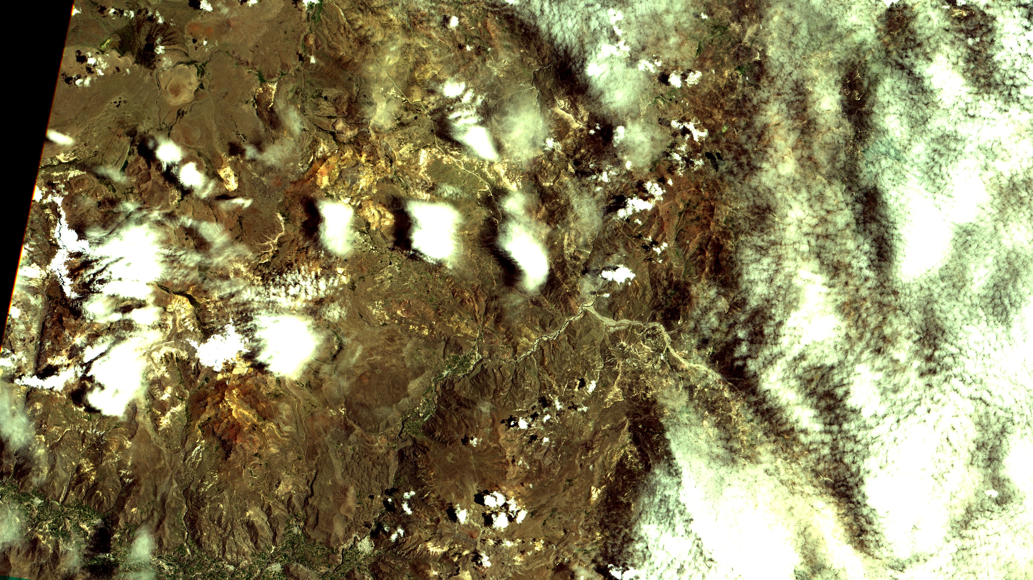
English: Nevado Mismi, 5.600m, Sul do Perú, ao pé do qual nasce o Rio Amazonas. O Nevado é a mancha branca entre duas nuvens também brancas, mas com sombra preta, no alto à esq. da imagem. Ao seu Norte a Quebrada Carhuasanta (vale em forma de U) que vai ao Rio Apurímac, afluente do Rio Ucayali que ao se unir ao Rio Marañón forma o Amazonas. Em marrom e amarelo solo exposto. Na parte de baixo da imagem, agricultura em verde no Vale do Rio Colca, que deságua no Oceano Pacífico. É um cânion profundo onde fica Chivay, 3.500m, com área urbana em salpicado branco, embaixo à dir. na imagem / Nevado Mismi, 18.300 ft, Southern Peru, under wich Amazon River is born. Mismi is at image top left, white spot between two clouds also white, but with black shadows. To its North runs Carhuasanta brook, down it U shaped valley, to Apurímac River, an Ucayali tributary who when joins Marañon River forms the Amazon. Exposed soils in brown and yellow. Crops in green at image bottom on Colca River valley, running West to the Pacific Ocean. It is a deep canyon where sits Chivay, 11,500 ft, with urban area in saltpepper, at image right bottom.
Imagem / Image CBERS4 MUX Nascente do Rio Amazonas no Perú / Amazon River Rising in Peru Coordenadas do centro da imagem / Image center: 15°33'35.2"S 71°39'11.7"W Data / Date: 26-01-2019 / 2019-26-01 RGB 765 (cor verdadeira / true color) Cena / Scene: 182 / 117 Autor / Author: Oton Barros (DSR/OBT/INPE) Imagem em HD / HD Image Visite-nos / Visit us: www.dsr.inpe.br |
| Date | |
| Source | https://www.flickr.com/photos/153282474@N02/40129376403/ |
| Author | Coordenação-Geral de Observação da Terra/INPE |
Licensing[edit]
This file is licensed under the Creative Commons Attribution-Share Alike 2.0 Generic license.
- You are free:
- to share – to copy, distribute and transmit the work
- to remix – to adapt the work
- Under the following conditions:
- attribution – You must give appropriate credit, provide a link to the license, and indicate if changes were made. You may do so in any reasonable manner, but not in any way that suggests the licensor endorses you or your use.
- share alike – If you remix, transform, or build upon the material, you must distribute your contributions under the same or compatible license as the original.
| This image was originally posted to Flickr by Coordenação-Geral de Observação da Terra/INPE at https://flickr.com/photos/153282474@N02/40129376403. It was reviewed on 9 April 2020 by FlickreviewR 2 and was confirmed to be licensed under the terms of the cc-by-sa-2.0. |
File history
Click on a date/time to view the file as it appeared at that time.
| Date/Time | Thumbnail | Dimensions | User | Comment | |
|---|---|---|---|---|---|
| current | 10:13, 9 April 2020 | | 3,496 × 1,966 (3.15 MB) | Jo-Jo Eumerus (talk | contribs) | Uploaded a work by Coordenação-Geral de Observação da Terra/INPE from https://www.flickr.com/photos/153282474@N02/40129376403/ with UploadWizard |
You cannot overwrite this file.
File usage on Commons
The following page uses this file:
.jpg&redirect=no)